


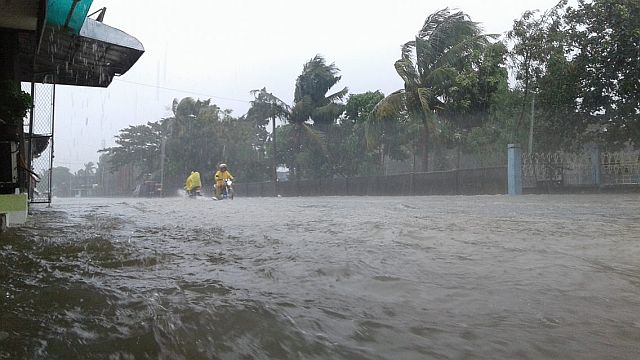
Continuous rains brought about by typhoon Karen since Friday have flooded the roads in Virac, Catanduanes.
(CONTRIBUTED PHOTO/Marlon San Esteban)
The stormy weather is unlikely to let up soon, with Typhoon “Karen” (international name: Sarika) expected to make landfall early on Sunday, and another storm expected to enter the Philippine area of responsibility on Monday.
In a press briefing late Saturday afternoon, Philippine Atmospheric, Geophysical and Astronomical Services Administration (Pagasa) weather forecaster Benison Estareja said “Karen” was expected to make landfall over Aurora sometime between 12 a.m. to 2 a.m., and then cross Central Luzon until noon.
As of press time, “Karen” is located 205 kilometers east of Infanta, Quezon. The typhoon is expected to move west-northwest at a faster pace of 22 kilometers per hour.
The typhoon is expected to exit the Luzon landmass via Pangasinan by Sunday afternoon, and exit the Philippine area of responsibility on Monday, Estareja said.
Estareja warned that even those areas that wouldn’t experience the typhoon’s landfall, but were within the 500-kilometer diameter of the typhoon, would be affected by strong rains and winds. Pagasa said on Saturday the concentration of rains were in the Bicol region.
Storm signals raised
“Karen” is packing maximum sustained winds of up to 130 kph near the center and gustiness of up to 180 kph.
As of Saturday evening, storm signal No. 3 is hoisted over Pangasinan, Tarlac, Nueva Ecija, Aurora, northern Quezon including Polilio Island, La Union, Benguet, Nueva Vizcaya, and Quirino.
Storm signal No. 2 has been declared over Ilocos Sur, southern Isabela, Mountain Province, Ifugao, the rest of Zambales, Pampanga, Bulacan, Bataan, Rizal, Metro Manila, the rest of Quezon, Camarines Norte and Catanduanes.
As of Saturday evening, storm signal No. 1 is up over Ilocos Norte, Abra, Kalinga, the rest of Isabela, southern Apayao, southern Cagayan, Oriental Mindoro, Cavite, Batangas, Laguna, Marinduque, Camarines Sur, and Albay including Burias Island.
Pagasa warnings
The state weather bureau warns areas with storm signals of the likelihood of flash floods and landslides, and those with storm signal No. 2 and 3 of storm surges of up to 2.6 meters high —“over the height of a person,” Estareja described.
Estareja also warned of landslides especially in the Aurora and northern Quezon areas, in the eastern portion of Sierra Madre.
Meanwhile, Tropical Storm “Haima” is still outside Philippine Area of Responsibility, and is expected to enter by Monday, the same time as “Karen” exits.
Estareja said that while “Haima” currently had an intensity of only 65 kph, as it remained at sea, it would likely intensify before entering the PAR as “Lawin” on Monday.
Disclaimer: The comments uploaded on this site do not necessarily represent or reflect the views of management and owner of Cebudailynews. We reserve the right to exclude comments that we deem to be inconsistent with our editorial standards.