


State of calamity in 6 barangays
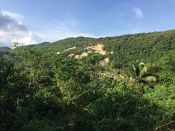
Aerial view of the areas affected by the series of landslides in Boljoon, Cebu. / CND PHOTO – Tonee Depojo
Due to the incessant landslides in a mountain village of the southeastern Cebu town of Boljoon, the Mines and Geosciences Bureau (MGB) of the Department of Environment and Natural Resources in Central Visayas (DENR–7) recommended declaring the affected area as a “permanent danger zone” and “no habitation zone.”
MGB-7, in a statement signed by Regional Director Loreta Alburo released Friday, proposed that only Sitio Camp Franco, also referred to as Calfranco by barangay and municipal officials, in Barangay Lower Becerril should be identified as a danger zone; but local government officials of Boljoon, a fifth-class municipality located more than 105 kilometers from Cebu City, decided to place under a state of calamity six of the 11 barangays that composed the town.
Ruben Niere, the public information officer (PIO) of the municipal government of Boljoon, told reporters yesterday afternoon that Barangays Lower Becerril, Upper Becerril, Nangka, San Antonio, Lunop, and Poblacion were placed under the state of calamity by the town council following the findings from MGB-7.
“Barangay Lower Becerril was the directly affected area, but the municipal council decided to include Barangays Nangka, Upper Becerril, Lunop and San Antonio since they cannot be accessed anymore. The road was damaged and needs extensive repair before it can be passable for all vehicles. (Therefore) supplies going to and from these places will be transported with difficulty,” explained Niere.
The continued landslide has damaged the 15-km Becerril–Nug-as Road that connects Barangay Poblacion, the town proper, to the mountain barangays of Lower and Upper Becerril, Nangka, Lunop and San Antonio.
As of Thursday, the road was no longer passable even to motorcycles since the incessant landslides created several cracks, which MGB-7 measured to have a width ranging from 20 to 60 centimeters.
Niere added that as of yesterday afternoon, they identified 18 families or about 100 individuals — 17 families from Sitio Camp Franco (or Calfranco) and one from Sitio Sangi — of Barangay Lower Becerril who will be the first batch of evacuees to be relocated to an area that they were still identifying.
“So far, 18 families will be relocated to a safer area. … We are still determining the feasible relocation site. We prioritized these families because they abandoned their houses, and are no longer fit for occupancy,” he said.
But according to the 2016 population count of the Philippine Statistics Authority, a total of around 9,000 individuals residing in the six affected barangays of Boljoon are affected by the declaration of a state of calamity.
Aside from the 18 families earlier identified by the local government of Boljoon, 17 more families or around 200 persons from Sitios Sangi and Upper Cansiloy (10 families from Sangi and seven from Upper Cansiloy) of Barangay Lower Becerril have left their houses on Monday to relocate to safer grounds.
Possible mudslides
Barangay Poblacion, which is located downstream of Lusopan River (MGB-7 spelled as Losopan), is placed at risk because of the two artificial dams made out of eroded earth, uprooted trees and fallen boulders.
MGB-7 warned of a possible mudslide in case the dams break due to pressure brought by impounded water. They added that the possible mudslide can reach Barangay Poblacion, which is located approximately four kilometers away from the blocked portions of Lusopan River.
“A debris from the landslide has blocked a section of the Losopan River causing the artificial damming of the river. This debris may also cause a mudslide towards barangay Poblacion if it is not immediately cleared prior to a heavy downpour,” MGB-7 explained in its statement.
Niere said the municipal council also placed Barangay Poblacion, with a population of over 4,000, under a state of calamity. He added that their decision was based on MGB-7’s findings and suggestions.
“The local government unit was also advised to cordon the area especially in the river ponding (sic) caused by the landslide debris as it is still considered a danger zone. The local disaster risk reduction management is also advised to monitor the water level in the upstream of Losopan River and progress of the ground cracks in the vicinity. Should there be rapid change in water level, the DRRM is advised to alert the residents in Sitio Campo Franco and Barangay Poblacion to avoid any untoward incidents,” MGB-7 said.
Rain, not fault line
MGB-7, meanwhile, attributed the series of landslides to the nonstop rain that Boljoon has experienced over the past several days.
State geologists revealed that the landslides were caused by the incessant downpour, wherein rains that lasted for five days have seeped through the cracks found on the surface of the mountainous terrain of the village.
“Five days of incessant downpour in Barangay Lower Becerril has caused the massive landslide in Sitio Camp Franco. The area has a ‘very high’ landslide susceptibility rating by the Geohazards Mapping and Assessment Team (GMAT) of MGB-7,” the findings stated.
“The rainwater that seeped through the numerous cracks, which range from 20 to 60 centimeters wide, in Barangay Lower Becerril has caused the over saturation of the ground prior to the breaking off of the debris from the face of the mountain,” they added.
Disaster officials from the municipal and provincial government initially reported that the landslide, which first struck a week ago on October 29, was brought by a movement in the fault line present in Boljoon, which cuts across Barangay Lower Becerril.\
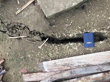
BIG cracks like this one are found on the soil and roads in Sitio Camp Franco (also known as Calfranco), Barangay Lower Becerril, Boljoon following the series of landslides since October 29, 2017 that has also destroyed houses.
Help from Phivolcs
“We were told by MGB-7 that they have no authority to declare whether or not this continued landslide was triggered by a movement in the fault line in Boljoon. They told us to consult Phivolcs (Philippine Institute of Volcanology and Seismology),” said Niere.
The PIO of Boljoon said they are planning to request the assistance of Phivolcs to give them “a more comprehensive” picture on the series of landslide happening in their town.
Data from Phivolcs revealed that Boljoon is one of the 17 areas that sit atop three major fault lines in Cebu.
“But in the meantime, the findings from MGB-7 will suffice to declare a state of calamity,” Niere said.
For their part, the Provincial Disaster Risk Reduction and Management Office (PDRRMO) said they are coordinating with the municipal’s Social Welfare Department to provide assistance to the affected families.
“We are now planning to provide safety kit and rice, tin roof and wooden materials, to the affected families, especially those in Barangay Lower Becerril,” said PDRRMO Chief Baltazar Tribunalo.
Rising water
Even as heavy equipment from both the province and the municipality continue to clear the river of impounded debris, the volume of the water impounded in the first artificial dam has reached 430,000 cubic-meter as of yesterday morning, revealed Tribunalo.
The first was formed on October 29 while the second, located 500 meters south of the first dam, was discovered by patrolling officials from Boljoon’s Municipal Disaster Risk Reduction and Management Office (MDRRMO) at dawn on November 1.
Boljoon MDRRMO Acting Chief Eutemio Ternate told Cebu Daily News in a phone interview that due to the rains their town has experienced since Thursday, the water level in the first dam has increased.
“On Tuesday, we managed to discharge a lot of water, but it has now returned to a depth of 40 feet. When we discharged water before the rains happened, its water level has decreased to 20 feet,” Ternate said.
However, he stated that the water level in the second dam remained steady at six to eight meters since they managed to drill a hole enough to discharge water at a much faster rate compared to the first dam.
“But still, the water from there (second dam) will gather at the first dam. And the volume, of course, will increase. Nevertheless, our heavy equipment deployed there is working to widen the riverbanks to ease pressure as well as to clear fallen debris that formed it. Good thing water is still being discharged from the first dam even at a very slow rate,” added Ternate.
Disclaimer: The comments uploaded on this site do not necessarily represent or reflect the views of management and owner of Cebudailynews. We reserve the right to exclude comments that we deem to be inconsistent with our editorial standards.