


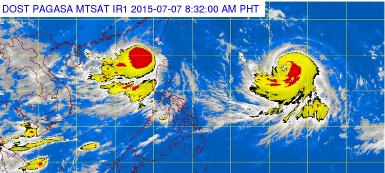
This satellite image from Pagasa shows the location of Tropical Storm Egay (international name: Linfa) and Typoon “Chan-hom.” Egay has left the Philippine Area of Responsibility Tuesday morning, while Chan-hom is expected to enter late Tuesday or early Wednesday. It will be named “Falcon.”(INQUIRER)
All storm signals were lifted as Tropical Storm “Egay” (international name: Linfa) moved out the Philippine area of responsibility (PAR) on Tuesday morning, the state weather bureau said.
As of 8 a.m. Egay was spotted 320 kilometers West Southwest of Basco, Batanes.
Northern Luzon was most affected by the weather disturbance.
But the Philippine Atmospheric, Geophysical and Astronomical Services Administration still warned of possible flashfloods and landslides due to “hanging habagat” or the southwest monsoon.
BACKSTORY: ‘Egay’ lashes Luzon, shuts down Metro Manila
Habagat is affecting Zambales, Bataan, Pangasinan, Benguet and the Ilocos region.
A yellow rainfall warning level has been raised in Zambales and Tarlac. Pagasa said that there could be possible flooding in low-lying areas as these provinces are expected to experience rainfall of about 7.5 to 15 millimeters per hour in the next three hours.
Fishermen and operators of small sea vessels were also warned to avoid the seaboards of Northern Luzon and western seaboard of Central Luzon.
Typhoon Chan-hom (international name), meanwhile, is expected to enter PAR by Tuesday evening or early Wednesday.
Once it enters PAR, it will be called “Falcon.”
The typhoon was last seen 1,700 kilometers east of Luzon and moved west northwest at 20 kilometers per hour.
It packed maximum sustained winds of 120 kph and gusts of up to 150 kph.
Pagasa’s Samuel Duran said that Chan-hom could still intensify into a supertyphoon.
Forecasters said that it won’t make landfall but it will enhance the southwest monsoon.
Disclaimer: The comments uploaded on this site do not necessarily represent or reflect the views of management and owner of Cebudailynews. We reserve the right to exclude comments that we deem to be inconsistent with our editorial standards.