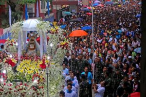
VIVA MOTHER MARY. Devotees join the procession of the Virgin of the Rule in Lapu-Lapu City in the afternoon of Tuesday, Nov. 20, 2018, despite the gloomy weather spawned by Tropical Depression ’Samuel,’ which threatens the Visayas.
As Tropical Depression Samuel approaches the islands of Cebu and Mactan, government officials have put in place measures to
reduce the potential impact of the weather disturbance.
All local government units (LGUs) in Cebu are now aiming for zero casualty as Samuel will make another landfall in the province this morning, November 21.
Hence, classes from pre-school to senior high school all over Cebu province and in the independent cities of Cebu, Mandaue and Lapu-Lapu were suspended since Monday afternoon.
Most universities and colleges in Metro Cebu also followed suit.
Boat trips remained grounded since the Philippine Coast Guard in Central Visayas (PCG – 7) canceled all sea trips on Monday when the state weather bureau hoisted Storm Signal No. 1 in the region.
As of noon yesterday, PCG-7 recorded a total of 1,579 passengers who were stranded in the different ports in Cebu.
On the other hand, a total of 13 flights from Cebu bound to Siargao Island and Manila were cancelled yesterday due to bad weather, the Mactan Cebu International Airport Authority (MCIAA) said in a statement yesterday.
In addition, all tourism activities were suspended yesterday morning, leaving several tourists stranded in the islands of Malapascua, Camotes, and Bantayan.
The entire Cebu was placed under red alert status as of 5 p.m. yesterday, or an hour before the Philippine Atmospheric Geophysical and Astronomical Services Administration (Pagasa) issued a general flood advisory in some of its river systems.
Under red alert, all disaster teams from LGUs down to the barangay level are mandated to monitor their respective surroundings 24/7, and start evacuating individuals residing in disaster-prone areas, especially in low-lying ones.
Pagasa likewise placed several river systems in Cebu under orange alert in its general flood advisory as of 6 p.m. yesterday.
This meant that heavy rainfall was expected within one hour since its issuance, and would result to a steady rise in the river’s water level.
However, it would not reach to its critical level.
The rivers and tributaries under the general flood advisory are Cotcot River in Liloan, Mananga River in Talisay City, Guinabasan River in Asturias, Balamban River in Balamban town, and Sapangdaku River in Toledo City.
State geologists from the Mines and Geosciences Bureau in Central Visayas (MGB-7) also issued a threat advisory to areas in Cebu, which they identified as highly susceptible to landslides.
Samuel’s Path
An unfavorable weather condition was already felt in Cebu since yesterday evening, when Samuel made its first landfall between the Dinagat-Leyte-Samar region.
Pagasa-Mactan Bureau Chief Al Quiblat told Cebu Daily News in a phone interview that it was expected to worsen today as Samuel barrels through the Central Visayas region.
“It is expected to make another landfall between Metro Cebu and Northern Cebu (on Wednesday) around 5 a.m. to 8 a.m.,” said Quiblat.
He added that Cebu would experience moderate to heavy rains starting today since Samuel was characterized to bring torrential rains, with an average of 50 millimeters per hour.
Rainfall rate beyond 35 millimeters per hour was considered torrential, and residents in low-lying areas were urged to evacuate.
Earlier forecasts showed that Samuel may bring rainfall at a rate of 90 millimeters per hour in Cebu.
But Quiblat said that this was not absolute since they described the weather disturbance’s cloud formation as irregular.
He added that Pagasa’s radar in Eastern Samar has already recorded rainfall rate at 130 millimeters per hour while other parts in Eastern Visayas experienced below 35 millimeters per hour.
“It’s an asymmetric type of tropical depression. Meaning, the rainwater is not evenly distributed throughout. It’s not balanced, and the clouds carrying the largest volume of rain are only concentrated in one area,” said Quiblat.
Nevertheless, he advised all government agencies to take the necessary precautionary measures to prevent flash floods and landslides.
“We are also calling on the residents themselves to comply with the mandates of their respectivelocal governments,” Quibaly added.
Based on the severe weather bulletin issued by Pagasa at 5 p.m. yesterday, the eye of Samuel was located 250 kilometers east of Maasin City, Southern Leyte or 165 km southeast of Guiuan, Eastern Samar.
It has also maintained its strength, packing winds up to 55 kilometers per hour (kph), with gustiness at up to 65 kph and moving in a northwest direction at 25 kph.
All provinces in the Visayas were placed under Storm Signal No. 1.
Storm Signal No. 1 was also hoisted over the provinces of Dinagat Islands, Surigao del Norte, Surigao del Sur, Agusan del Norte, Agusan del Sur, Misamis Oriental, and Camiguin in Mindanao; and Masbate including Ticao Island, Romblon, southern Oriental Mindoro, southern Occidental Mindoro, and Palawan including Cuyo Island and the Calamian Group of Islands in Luzon.
Preemptive evacuation
Even if Samuel was yet to hit Cebu, the Police Regional Office in Central Visayas (PRO-7) has recorded 77 individuals from different parts in Cebu who were evacuated to safer areas as of yesterday morning.
The Cebu City Government also conducted a preemptive evacuation yesterday evening for 150 individuals living in Sitio Sandayong in Barangay Buhisan, which is considered as a landslide-prone area by MGB-7.
They were all housed inside Buhisan’s Sports Complex.
Meanwhile, in Naga City, where a landslide recently hit Barangay Tinaan and claimed the lives of 78 individuals, its City Disaster Risk Reduction and Management Office (CDRRMO) continue to monitor flood and landslide prone areas outside the 1-kilometer radius from ground zero of the landslide.
City Councilor Junjie Cruz, who heads the Naga CDRRMO, assured that the residents from the immediate danger zone are safe as most of them are still housed in evacuation centers.