
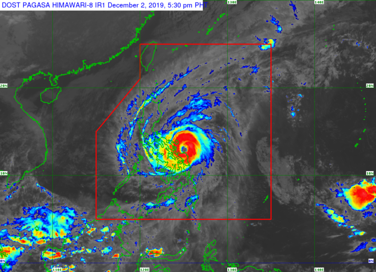
Satellite image from Pagasa
MANILA, Philippines — Typhoon Tisoy slightly intensified as its “eyewall” reaches Northern Samar, the Philippine Atmospheric, Geophysical and Astronomical Services Administration (Pagasa) reported Monday afternoon.
According to the state weather bureau’s 5 p.m. weather bulletin, Tisoy was spotted 155 kilometers east of Juban, Sorsogon, packing maximum sustained winds of 155 kilometers per hour (kph) and gustiness of up to 190 kph as of 4 p.m.
Pagasa said Tisoy somewhat decelerated at 15 kph as it travels westward.
Pagasa said the southern eyewall of Tisoy is bringing intense rainfall and violent winds over Northern Samar. Tisoy’s eyewall is also expected to hit Sorsogon, Albay, Catanduanes, and Camarines Sur in the next 3 hours, Pagasa added.
Pagasa said Tisoy is forecast to make landfall over Albay–Sorsogon area between Monday night and early Tuesday morning.
Meanwhile, the state weather bureau has raised Tropical Cyclone Wind Signal warnings over the following areas:
Signal No. 3
- Catanduanes
- Camarines Sur
- Albay
- Sorsogon
- Camarines Norte
- Masbate including Ticao and Burias Islands
- Romblon
- Southern portion of Quezon (Perez, Alabama, Quezon, Atimonan, Padre Burgos, Agdangan, Plaridel, Unisan, Pitogo, Gumaca, Lopez, Macalelon, General Luna, Calauag, Guinayangan, Tagkawayan, Buenavista, Mulanay, San Narciso, San Francisco, San Andres)
- Marinduque
- Northern Samar
- Northern portion of Eastern Samar (Can-avid, Dolores, Maslog, Oras, Article, Jipapad, San Policarpio)
Northern portion of Samar (Catbalogan, Jiabong, Motiong, Paranas, San Jose de Juan, San Jorge, Pagsanghan, Tarangnan, Sta. Margarita, Gandara, Matuguinao, Calbayog, Tagapul-an, Almagro, Sto. Nino)
Signal No. 2
- Metro Manila
- Bulacan
- Bataan
- Tarlac
- Pampanga
- Nueva Ecija
- Southern Aurora (Dipaculao, Maria Aurora, Baler, San Luis, Dingalan)
- Cavite
- Batangas
- Laguna
- Rizal
- Rest of Quezon (including Polilio Islands)
- Oriental Mindoro
- Occidental Mindoro
- Calamian Islands
- Zambales
- Rest of Eastern Samar
- Rest of Samar
- Biliran
- Aklan
- Capiz
- Antique
- Iloilo
- Northern portion of Negros Occidental (Talisay, Calatrava, Silay, Enrique B. Magalona, Victorias, Manapla, Cadiz, Sagay, Escalante, Toboso)
- Northern Cebu (Daanbantayan, Bantayan, Madridejos, Sante Fe, Medellin, Bogo City, San Remigio, Tabogon, Tabuelan, Tuburan, Carmen Borbon, Sogod, Catmon, Asturias, Camotes Islands)
- Northern portion of Leyte (Baybay, Mahaplag, Abuyog, Javier, Macarthur, Mayorga, La Paz, Dulag, Albuera, Barauen, Julita, Tolosa, Tanauan, Tabontabon, Dagami, Pastrana, Palo, Sta. Fe, Tacloban, Alangalang, Jaro, Babatngon, San Miguel, Barugo, Tunga, Carigara, Capoocan, Leyte, Calubian, San Isidro, Tabango, Villaba, Kananga, Matag-ob, Palompon, Isabel, Merida, Ormoc)
- Guimaras
Signal No. 1
- Southern Isabela (Palanan, Dinapique, San Mariano, San Guillermo, Benito Soliven, Naguilian, Reina Mercedes, Luna, Aurora, Cabatuan, San Mateo, Cauayan City, Alicia, Angadanan, Ramon, San Isidro, Echague, Cordon, Santiago City, Jones, San Agustin)
- Mountain Province
- Ifugao
- Benguet
- Nueva Vizcaya
- Ilocos Sur
- La Union
- Pangasinan
- Quirino
- Rest of Aurora
- Rest of Negros Occidental
- Metro Cebu (Balamban, Toledo City, Pinamungahan, Aloguinsan, Naga City, Talisay City, Cordova, Minglanilla, Lapu-Lapu City, Mandaue City, Cebu City, Consolacion, Liloan, Compostela, Danao City)
- Rest of Leyte
- Southern Leyte
- Dinagat Islands
- Siargao Island
According to Pagasa, frequent to continuous heavy to intense rains are expected over the Bicol region, Northern Samar, Southern Quezon, Marinduque, and Romblon between Monday night and Tuesday morning.
Frequent to continuous heavy rains, meanwhile, may likely be experienced in Samar, Eastern Samar, Rizal, the rest of Quezon, Laguna, and Oriental Mindoro while moderate to intermittent heavy rains is predicted to occur over Metro Manila, Occidental Mindoro, the rest of CALABARZON, Cagayan, Isabela, Aurora, and the rest of Eastern Visayas. | KGA