

MANILA, Philippines — A new tropical depression may enter the Philippine Area of Responsibility (PAR) by Monday, the state weather bureau said.
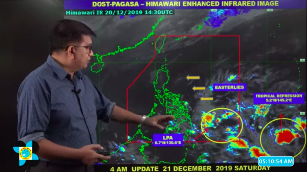
In its 4 a.m. live weather update on Saturday, Philippine Atmospheric, Geophysical and Astronomical Services Administration (Pagasa) Meno Mendoza said that the new weather disturbance was last spotted at 2,115 kilometers east of Mindanao.
The tropical depression packed maximum sustained winds of 45 kilometers per hour (kph) near the center, and gustiness of up to 60 kph.
The weather disturbance was also monitored moving west at 20 kph.
A low-pressure area (LPA), meanwhile, was also being monitored by the state weather bureau, and was spotted 505 kilometers east-southeast of Hinatuan, Surigao del Sur.
This LPA, however, is less likely to intensify, Mendoza said.
The trough of the LPA will bring cloudy skies with scattered rain showers and thunderstorms in Caraga, Davao Region and eastern Visayas.
Cloudy skies with isolated rain showers and thunderstorms are expected over Cagayan, Isabela, Aurora and Quezon due to the easterlies, the weather specialist said.
Mendoza added that the easterlies will also bring partly cloudy to cloudy skies with isolated rain showers or thunderstorms over Metro Manila and the rest of the country.