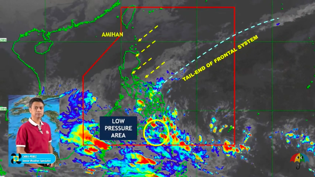

MANILA, Philippines — A low-pressure area (LPA) and the intertropical convergence zone (ITCZ) will bring cloudy skies with scattered rain showers and thunderstorms to Palawan, Visayas and Mindanao on Monday, according to the Philippine Atmospheric, Geophysical and Astronomical Services Administration (Pagasa).
Based on the weather forecast issued by Pagasa at 4 a.m., the LPA was last spotted 100 kilometers southwest of Cotabato City.
“Sa buong Visayas at Mindanao maulap at kalat-kalat na pag-ulan at pagkulog ang dala ng ITCZ. ‘Yung binabanggit nating LPA sa may Mindanao, bagamat maliit ang tsansa na maging bagyo, posibleng makaapekto pa rin sa Mindanao at maging sa Palawan area sa susunod na 24 to 48 hours,” Pagasa weather specialist Chris Perez said.
(In the entire Visayas and Mindanao, there will be cloudy skies and scattered rain showers and thunderstorms due to the ITCZ. The LPA, even though it is not likely to develop into a storm, may affect Mindanao and Palawan in the next 24 to 48 hours.)
Meanwhile, Pagasa’s forecast also showed that the Bicol region, Quezon, and the rest of the Mimaropa (Mindoro, Marinduque, Romblon, Palawan) region will have cloudy skies with scattered rain showers and thunderstorms due to the tail-end of a frontal system.
Metro Manila, Cagayan Valley, Apayao, Kalinga, Mountain Province, Ifugao, Aurora, and the rest of Calabarzon (Cavite, Laguna, Batangas, Rizal, Quezon) will experience cloudy skies with rains due to the northeast monsoon.
The rest of Luzon will have partly cloudy to cloudy skies with isolated light rains also because of the northeast monsoon, according to Pagasa.
Forecast temperature range in key cities/areas:
Metro Manila: 23 to 30 degrees Celsius
Baguio City: 14 to 23 degrees Celsius
Laoag City: 21 to 28 degrees Celsius
Tuguegarao: 19 to 26 degrees Celsius
Legazpi City: 24 to 28 degrees Celsius
Puerto Princesa City: 24 to 31 degrees Celsius