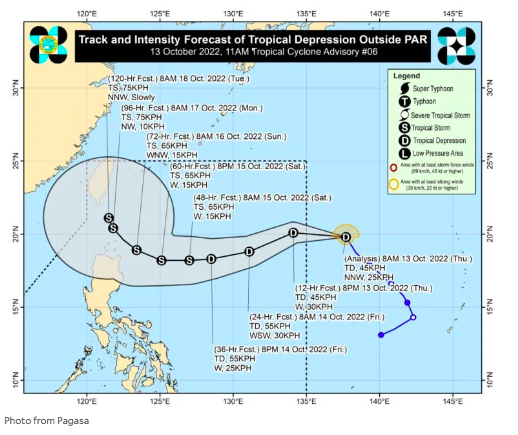

MANILA, Philippines — A new tropical depression is moving closer to the Philippine area of responsibility (PAR), according to the state weather bureau. It will be locally named Neneng.
Based on the 11 a.m. advisory of the Philippine Atmospheric, Geophysical and Astronomical Services Administration (Pagasa), the tropical depression was last located 1,400 kilometers east of extreme northern Luzon and may enter PAR within Thursday. It was packing maximum sustained winds of up to 45 kilometers per hour (kph) and gustiness of 55 kph as it moved northwestward.
READ: Tropical depression may enter PAR on Thursday
Pagasa also said the tropical depression may possibly strengthen into a tropical storm as it traverses the Philippine Sea. Further intensification has not been ruled out and wind alarm of up to Signal No. 2 may be raised over Batanes and parts of northern Luzon by then, it added.
READ: Understanding ‘explosive intensification’: The case of Super Typhoon Karding
Once it enters the PAR, Tropical Depression Neneng is anticipated to bring heavy rain over extreme northern Luzon beginning Saturday, October 15, the state weather service said.
The weather event is likewise seen to cause rough waves on Friday which may pose hazard to seacrafts, Pagasa also said.
RELATED STORY
Pagasa: Maymay weakens into an LPA, 2 new weather disturbances looming
Click here for more weather related news.