
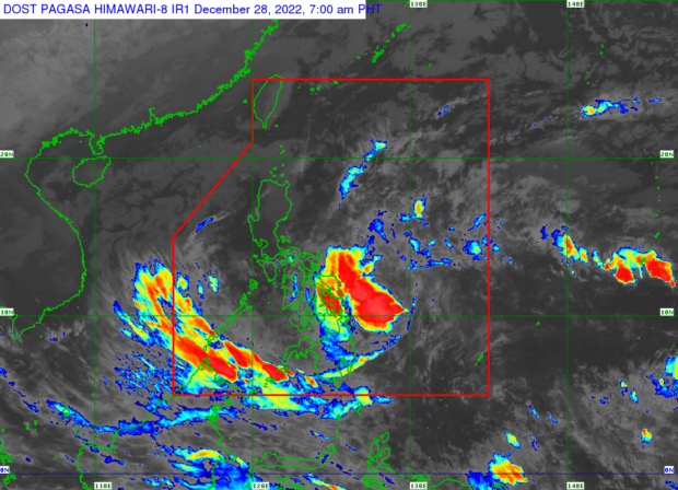
MANILA, Philippines — The low-pressure area (LPA) inside the Philippine area of responsibility (PAR) may intensify into a tropical cyclone and will bring overcast skies and rains to parts of the country on Wednesday, December 28, 2022, according to the state weather bureau.
The Philippine Atmospheric, Geophysical, and Astronomical Services Administration (Pagasa) said that the LPA was last spotted 475 kilometers east of Hinatuan, Surigao del Sur.
“Maging bagyo man o hindi itong low pressure area na ito, nakikita natin na magdadala ito ng pag-ulan, lalo na sa Kabisayaan, kasama rin itong bahagi ng Zamboanga, Northern Mindanao kasama rin yung Caraga. At inaasahan natin na naari itong kumilos pa northwest, posible rin po maapekto yung bahagi ng Bicol region, bandang araw naman ng Biyernes” said Pagasa weather specialist Obet Badrina.
(Whether or not the low-pressure area intensifies into a storm, it is forecast to trigger rains, especially in Visayas, parts of Zamboanga, Northern Mindanao, including the Caraga region. And we expect it to move northwest and possibly affect the Bicol region by Friday).
Pagasa warned of possible flash floods and landslides in rain-affected areas, including Palawan and the Davao region.
Meanwhile, the cold winds of the northeast monsoon or “amihan” are expected to bring cloudy skies with rain to Cagayan Valley, Cordillera Administrative Region, Aurora, Quezon, and the Bicol region.
Gale warnings are up over the following areas due to the northeast monsoon winds:
- Batanes
- Cagayan including Babuyan Islands
- Isabela
- Aurora
- Ilocos Norte
- Ilocos Sur
- La Union
- Pangasinan
- Zambales
- Quezon (General Nakar, Mauban, Sariaya, Lucena City, Pagbilao, Atimonan, Padre Burgos, Agdangan, Unisan, Pitogo, Macalelon, General Luna, Catanauan, Mulanay, San Francisco, San Andres, Buenavista, San Narciso, Guinayangan, Tagkawayan, Gumaca, Plaridel, Lopez, Calauag, Quezon, Alabat, And Perez) including Polillo Islands (the Northern Coast Of Panukulan, Burdeos, eastern Coast Of Polilio, Patnanungan, and Jomalig)
- Camarines Norte
- Camarines Sur
- Catanduanes
- Masbate including Burias and Ticao Islands, Albay, Sorsogon, Romblon, and Marinduque
- Batangas
- Oriental Mindoro
- Occidental Mindoro including Lubang Island
- Palawan including Calamian, Cuyo, and Kalayaan Islands
Fishermen and crewmen of small vessels have been advised against setting sail in affected areas.
Forecast temperature range on Wednesday in key cities / areas:
- Metro Manila: 21 to 27 degrees Celsius
- Baguio City: 12 to 19 degrees Celsius
- Laoag City: 19 to 30 degrees Celsius
- Tuguegarao: 18 to 25 degrees Celsius
- Legazpi City: 24 to 28 degrees Celsius
- Puerto Princesa City: 24 to 29 degrees Celsius
- Tagaytay: 20 to 25 degrees Celsius
- Kalayaan Islands: 24 to 29 degrees Celsius
- Iloilo City: 24 to 28 degrees Celsius
- Cebu: 24 to 28 degrees Celsius
- Tacloban City: 23 to 27 degrees Celsius
- Cagayan De Oro City: 23 to 26 degrees Celsius
- Zamboanga City: 24 to 28 degrees Celsius
- Davao City: 21 to 31 degrees Celsius
RELATED STORIES:
LPA hovers east of Mindanao; becoming a cyclone a possibility says Pagasa