
Track of Typhoon Goring from Pagasa’s website
MANILA, Philippines — Typhoon Goring (international name: Saola) “rapidly intensified over the sea east of Babuyan Islands,” the Philippine Atmospheric, Geophysical and Astronomical Services Administration (Pagasa) said Saturday.
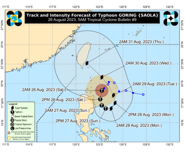
In its 5 a.m. tropical cyclone bulletin, Pagasa said Goring was moving southwestward at 10 kilometers per hour (kph) and packing maximum sustained winds of 140 kph near the center and gustiness of up to 170 kph.
Goring’s eye was located 185 km east-northeast of Aparri, Cagayan.
Pagasa also said that five towns in the northeastern portions of mainland Cagayan and Isabela were placed under Tropical Cyclone Wind Signal No. 2, where winds between 62 kph and 88 kph may be expected in at least 24 hours.
These five areas were Santa Ana and Gonzaga in Cagayan; and Divilacan, Palanan, and Maconacon in Isabela.
READ: LIVE UPDATES: Typhoon Goring
- Batanes
- Babuyan Island
- The eastern portion of mainland Cagayan (Lal-Lo, Gattaran, Baggao, Peñablanca, Santa Teresita, Buguey, Camalaniugan, Aparri, Ballesteros, Allacapan)
- The eastern portion of Isabela (Dinapigue, San Mariano, San Pablo, Cabagan, Tumauini, Ilagan City)
- The northern portion of Aurora (Dilasag, Casiguran)
The state weather bureau’s 5 a.m. weather forecast likewise showed that Saturday’s accumulated rainfall in the eastern portion of mainland Cagayan may be 100 to 200 millimeters (mm). In Babuyan Islands, the rest of mainland Cagayan, the northeastern portion of Isabela, Abra, the northern portion of Apayao, Ilocos Norte, and Ilocos Sur, the accumulated rainfall may be 50 to 100 mm, it added.
Goring is predicted to leave the Philippine area of responsibility by Sunday (August 27) as it is estimated to strengthen into a super typhoon by Monday.
RELATED STORIES
Goring now a typhoon; Signal No. 2 up over northeastern Cagayan
Tropical Storm Goring slightly intensifies as Signal No. 1 stays in 4 Luzon areas