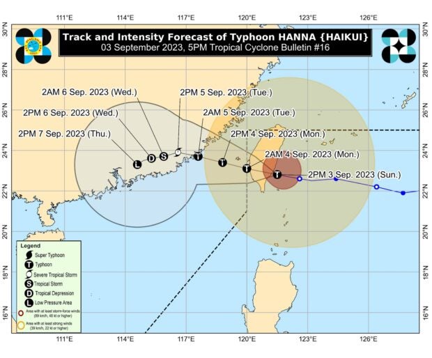
Track of Typhoon Hanna, with international name is Haikui, as it exits the Philippine area of responsibility. Image from Pagasa
MANILA, Philippines — Typhoon Hanna (international name: Haikui) made landfall in Taitung County, Taiwan, around 2 p.m. on Sunday, according to the Philippine Atmospheric, Geophysical and Astronomical Services Administration (Pagasa).
In its 5 p.m. cyclone update, the state weather bureau reported that Hanna slightly accelerated from 10 kilometers per hour (kph) to 20 kph as it moved west-northwestward. It carries maximum sustained winds of 155 kph with gusts of up to 255 kph.
Although the typhoon is forecast to exit the Philippine area of responsibility (PAR) by tonight or Monday morning, wind signals remained hoisted in Batanes and Babuyan Islands, which will likely experience heavy rainfall for the rest of the day.
Hanna would also continue to enhance the southwest monsoon, locally known as “habagat,” which will bring rains over the western portions of Luzon and Antique for the next three days.
It is also expected to bring gusty conditions in Batanes, Babuyan Islands, Ilocos Region, Abra, Benguet, Apayao, Nueva Vizcaya, Zambales, Pampanga, Bataan, Aurora, Bulacan, Metro Manila, Calabarzon (Cavite, Laguna, Batangas, Rizal, and Quezon), and most of Bicol Region, Mimaropa (Mindoro Oriental and Occidental, Marinduque, Romblon, and Palawan), and Western Visayas on Monday.
Due to the combined effects of Hanna and habagat, the state weather bureau also cautioned that a gale warning is still raised over the northern and western seaboards of Luzon, the eastern seaboards of Central and Southern Luzon, portions of seaboards of Northern Quezon, the southern seaboard of Southern Luzon, and the western seaboard of Visayas.
After leaving PAR, Hanna is expected to weaken into a severe tropical storm and make its final landfall along the coast of Guangdong or Fujian, China, on Tuesday (September 5).
RELATED STORIES:
Hanna slows down while southwest monsoon continues to dump rain over Luzon
Typhoon Hanna slightly intensifies; Signal No. 1 stays in Batanes, parts of Babuyan Islands