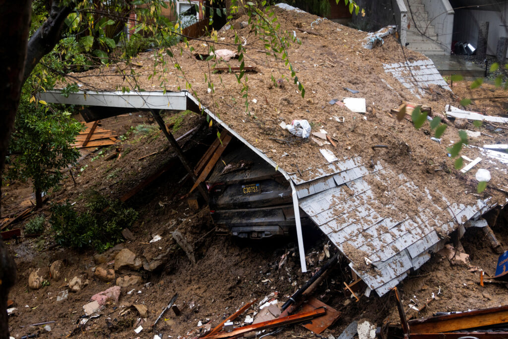
The remains of a home destroyed by a mudslide caused by the ongoing rain storm in Los Angeles, California, U.S., February 5, 2024 due to the second Pineapple Express that hit the West Coast. |REUTERS
LOS ANGELES — A deadly Pacific storm, the second “Pineapple Express” to sweep the West Coast in less than a week, stalled over Southern California on Monday, unleashing torrential downpours that triggered street flooding and mudslides throughout the region.
Extreme-weather advisories for floods, high wind and winter storm conditions were posted on Monday across parts of California and southwestern Arizona where some 35 million people live.
The National Weather Service documented staggering rainfall amounts from the storm, which lashed Northern California on Sunday with hurricane-force gusts of wind, along with heavy precipitation that intensified as the system moved south on Sunday night and Monday.
READ: US airlines cancel over 2,000 flights due to massive winter storm
The National Weather Service (NWS) said more than 10 inches (25.4 cm) of rain had fallen since Sunday across the Los Angeles area, the nation’s second-largest city, with much more expected before showers were due to taper off on Tuesday.
“Significant flooding is ongoing and expected to expand,” the NWS said in a notice posted online.
The intense rainfall, with heavy snow in high-elevation mountain areas, was carried to California by a storm system meteorologists call an atmospheric river, a vast airborne current of dense moisture funneled inland from the Pacific.
Rain falls over cars stuck by a mudslide, caused by an ongoing rain storm in Studio City, California, U.S., February 5, 2024.| REUTERS
The latest tempest, and a less powerful storm that hit California on Wednesday and Thursday, also qualified as a “Pineapple Express,” a type of atmospheric river originating from the subtropical waters around Hawaii.
Winds gusting to 75 miles per hour (121 kph) on Sunday downed trees and utility lines across the San Francisco Bay Area and California’s Central Coast, knocking out power to roughly 875,000 homes at the storm’s peak in that region.
At least two people were killed by wind-toppled trees on Sunday – an 82-year-old man in the former gold rush town of Yuba City and a 45-year-old man at Boulder Creek in the coastal Santa Cruz Mountains
The greatest flash-flooding threat on Monday centered on Southern California, the NWS said, as the system slowly pivoted and pushed farther into the interior of California, but forecasters said “catastrophic” impacts were unlikely.
“There is widespread moderate flooding, but right now things seem to be somewhat manageable,” said Daniel Swain, a meteorologist and climate scientist at the University of California, Los Angeles, during a briefing on YouTube on Monday.
READ:
Still, rescue teams have pulled dozens of people to safety statewide, mostly motorists stranded in cars by rising waters when they tried to drive through flooded roadways, according to Brian Ferguson, spokesperson for the Governor’s Office of Emergency Services (OES).
He said evacuation orders also were in effect for several Southern California neighborhoods considered to be at particularly high risk of flash floods and mudslides.
“We’re not out of the woods yet,” Ferguson told Reuters by telephone. “There could continue be very dangerous impacts all through Southern California today and tomorrow.”
Overnight, at least five homes sustained damage from a landslide in the Beverly Crest, a neighborhood in the Santa Monica Mountains west of downtown Los Angeles. Three more homes were damaged by a landslide in Encino, a neighborhood in the San Fernando Valley region, the city fire department said.
No injuries were reported in either neighborhood.
In Santa Barbara, about 95 miles (153 km) north of Los Angeles, the normally placid Mission Creek running through the city was close to spilling over its banks after 3 to 6 inches (8 to 15 cm) of rain fell in Central California during the weekend.
Earlier, authorities urged residents to be prepared for extremely dangerous conditions, especially in the Hollywood Hills of Los Angeles and in the Santa Monica Mountains.
California Governor Gavin Newsom on Sunday declared a state of emergency in eight counties with a combined population of more than 20 million people.