


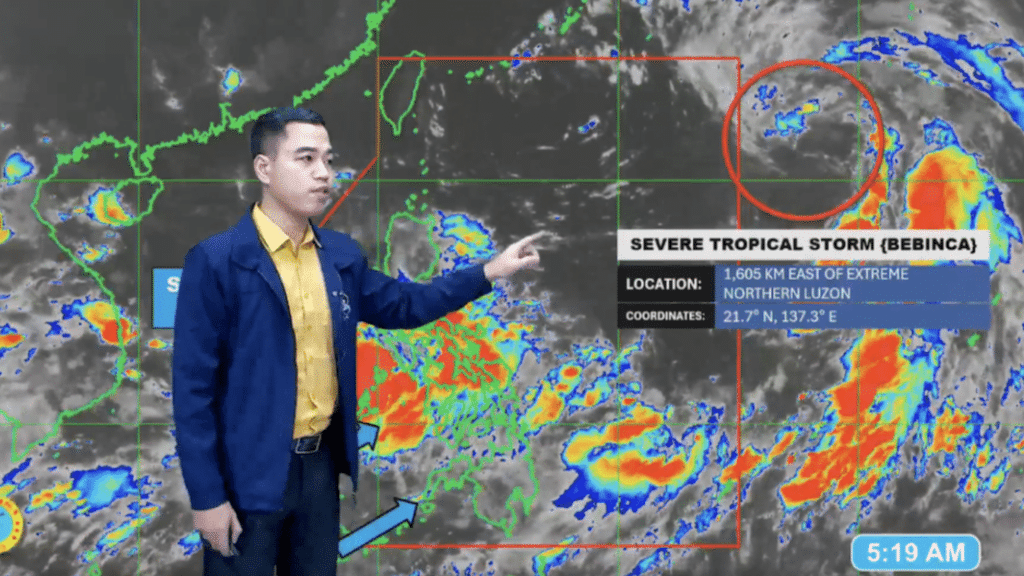

Benison Estareja, weather specialist of the Philippine Atmospheric, Geophysical and Astronomical Services Administration (Pagasa) gives updates of the weather at 4 a.m. | screengrab from Pagasa 5 a.m. advisory video
CEBU CITY, Philippines — The severe tropical storm with the international name Bebinca is expected to enter the Philippine Area of Responsibility (PAR) this afternoon or evening, September 13, and it will then be called Tropical Storm Ferdie. That is according to the state weather bureau this morning.
According to Benison Estareja, weather specialist of the Philippine Atmospheric, Geophysical and Astronomical Services Administration (Pagasa), Bebinca may possibly enter PAR east of extreme northern Luzon and will exit the country in a few hours.
READ MORE:
‘Bebinca’ may enter PAR on Friday, chances of landfall slim
Bebinca’s trough, habagat to bring rain in most of PH on Sept. 12
EXPLAINER: What do color-coded rainfall warnings mean?
And once it will enter the PAR, Bebinca will be locally called Tropical Storm Ferdie, the sixth storm to enter the country this year, Estareja said.
“Pero after a few hours, lalabas ito sa ating PAR, patungo sa southern islands of Japan, kung saan posibleng lumakas pa as a typhoon,” he said.
(After a few hours, it will exit our PAR, it will head to the southern islands of Japan, where it may possibly intensify as a typhoon.)
READ MORE: ‘Bebinca’ to enhance habagat, rains in Cebu expected in next 4 days
In the 5 a.m. weather advisory of Pagasa, Estareja said that Bebinca as of that 3 a.m. was spotted east of Batanes.
“Si Bebinca higit namataan mga 1,605 kilometers sa silangan ng Batanes at nasa labas pa rin ito ng ating Philippine Area of Responsibility at (Ito) ay may taglay na hangin na 95 kilometers per hour,” Estareja said.
(Bebinca is spotted 1,605 kilometers east of Batanes and it is still outside the Philippine Area of Responsibility and it has winds of 95 kilometers per hour.)
He also said that most parts of the country would continue to experience rains due to the southwest monsoon or the habagat, which had been enhanced by the trough of Bebinca.
Pagasa also said in its 24-hour weather forecast issued at 4 a.m. today, the southwest monsoon or habagat will affect southern Luzon, Visayas and Mindanao while the trough of Bebinca would affect the rest of Luzon.