
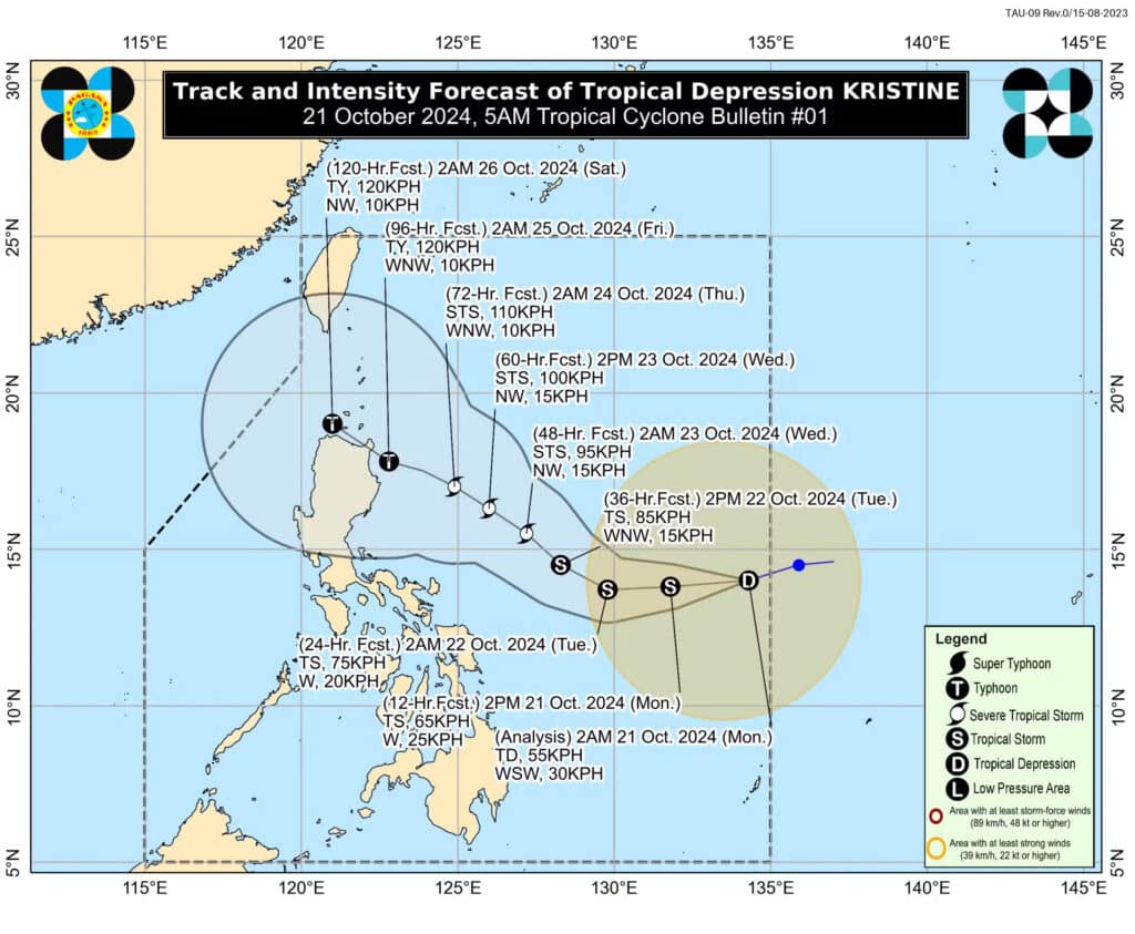
Forecast track and intensification of Tropical Depression Kristine, which entered the Philippine area of responsibility (PAR) early Monday morning, October 21, 2024. Kristine is forecast to develop into a typhoon before landfall over Northern Luzon towards the weekend. Photo from Pagasa
MANILA, Philippines — The state weather bureau said that Tropical Depression Kristine had entered the Philippine area of responsibility (PAR) early Monday morning.
The Philippine Atmospheric, Geophysical and Astronomical Services Administration (Pagasa) has also forecast that Kristine would develop into a typhoon before landfall over Northern Luzon towards the weekend.
READ MORE:
EXPLAINER: What do color-coded rainfall warnings mean?
LPA to enter PAR and become a storm in next 24 hrs – Pagasa
Pagasa: Rains on Monday over most parts of PH due to LPA’s trough
Kristine was 1,050 kilometers east of southeastern Luzon as of 5 a.m., October 21, carrying maximum wind speeds of 55 kilometers per hour (kph) near the center with gustiness of up to 70 kph, said Pagasa.
“Kristine is forecast to intensify into a tropical storm in the next 12 hours,” Pagasa said. “It may reach severe tropical storm category by tomorrow (Tuesday) afternoon or evening and typhoon category by Thursday (24 October) afternoon or evening, prior to landfall over the northeastern portion of Cagayan.”
Pagasa also raised the possibility of Tropical Depression Kristine further strengthening as it hovers over the Philippine Sea.
“Since this tropical cyclone is still over the Philippine Sea, further intensification is likely, given the favorable environmental conditions for development over the area,” the state weather service explained.
For now, Pagasa placed Catanduanes under Tropical Cyclone Wind Signal No. 2 where 62 kph to 88 kph wind speeds may be expected in at least 24 hours due to the tropical depression. Affected areas were advised to take caution as minor to moderate impacts to life and property are likely in this weather condition.
Northern Samar and Eastern Samar, meanwhile, were under Tropical Cyclone Wind Signal No. 1 where wind speeds between 39 kph and 61 kph are anticipated. Pagasa said minimal to minor threats to life and property are possible in places under this weather signal.