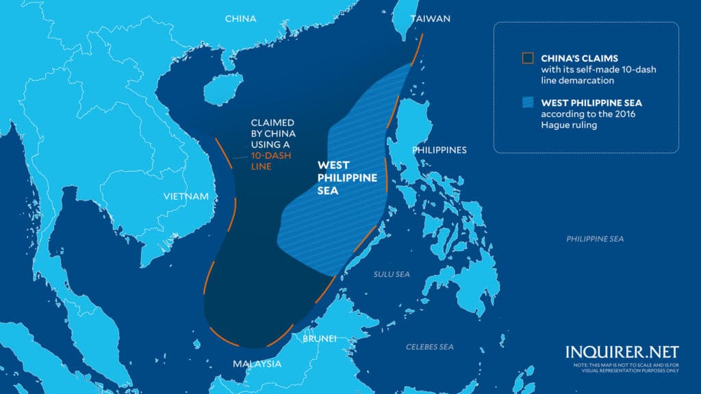
This map is not to scale and is for visual representation purposes only. – A new Philippine map that includes the West Philippine Sea (WPS) as part of its jurisdiction will be released soon, the National Mapping and Resource Information Authority (Namria) said Friday, November 8, 2024. Graphics by: Samuel Yap / INQUIRER.net
MANILA, Philippines — The National Mapping and Resource Information Authority (Namria) said a new Philippine map that would include the West Philippine Sea (WPS) as part of its jurisdiction would be released soon.
“[we] already have the maps prepared” and that they were just awaiting the issuance of the implementing rules and regulations (IRR) of the Philippine Maritime Zones Act “in order for us to modify or revise the maps that we have prepared accordingly until its final publication,” said Namria Administrator Peter Tiangco on Friday.
President Ferdinand Marcos Jr. signed earlier on Friday the Philippine Maritime Zones Act, which will also be known as Republic Act (RA) No. 12064, that aims to declare the country’s maritime zones in accordance with the standards set by the United Nations Convention on the Law of the Sea (UNCLOS).
READ MORE:
Marcos signs laws charting PH maritime zones, sea lanes
Marcos: West Philippine Sea not an imagination, ‘it is ours’
The Philippine Maritime Zones Act will likewise clarify the geographical extent of the Philippine maritime domain and specify the legal powers that the Philippines may exercise over these areas.
In an ambush interview after a Palace briefing, Tiangco was also asked about the revised map of China – from nine-dash line to 10-dash line, which incorporates Taiwan and most of the West Philippine Sea – in August 2023.
Tiangco pointed out the “big difference” between the new Philippine map and the modified China map.
“The big difference here is that our map has legal basis supported by existing laws,” he stressed in mixed Filipino and English.
“Regarding what China did, I’m not sure about that. But rest assured that what we’ll be doing with ours will all be in accordance with existing laws,” he also said, referring to line segments asserting China’s claims over parts of the South China Sea.
Apart from signing the Philippine Maritime Zones Act, Marcos likewise affirmed on Friday the Philippine Archipelagic Sea Lanes Act (Republic Act No. 12065), which ensures the protection of the country’s sovereignty and maritime domain.
It will design routes and areas that shall be utilized and accessed by foreign military vessels and foreign-registered aircraft for passage – which follows the UNCLOS and the Convention on International Civil Aviation, or the “Chicago Convention.”
For comprehensive coverage, in-depth analysis, visit our special page for West Philippine Sea updates. Stay informed with articles, videos, and expert opinions.

