
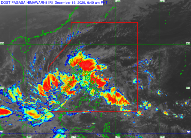
MANILA, Philippines – Moderate to intense rainfall and strong winds are expected in many parts of the country on Saturday due to the combined effect of Tropical Depression Vicky and the tail-end of a frontal system, the Philippine Atmospheric, Geophysical and Astronomical Services Administration (Pagasa) said.
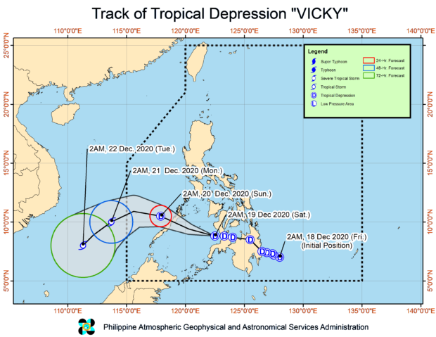
Tropical Cyclone Wind Signal Number 1 remains in effect over parts pf Luzon, Visayas and Mindanao as Vicky is forecast to cross the central or northern part of Palawan this afternoon.
Vicky was spotted at 7 a.m. some 240 kilometers west of Dipolog City, Zamboanga del Norte or 285 kilometers east southeast of Puerto Princesa City, Palawan and over the Sulu Sea with maximum sustained winds of 45 kilometers per hour (kph) near the center and gustiness of up to 55 kph, while moving west at 25 kph.
Rainfall alert
Pagasa, in its 8 a.m. severe weather bulletin, said moderate to heavy with at times intense rains over Calabarzon, Bicol region, Visayas, Aurora, Dinagat Islands, Surigao del Norte, Surigao del Sur, Agusan del Norte, Camiguin, Misamis Oriental, Oriental Mindoro, Marinduque, and the northern and central portions of Palawan including Calamian, Cuyo, and Cagayancillo Islands.
Light to moderate with at times heavy rains are expected over Cagayan Valley, Apayao, Kalinga, Mountain Province, Ifugao, Metro Manila, and the rest of Central Luzon, Mimaropa region and the Cordillera Administrative Region, Pagasa added.

‘Watch out for flash floods, landslides’
Flash floods and landslides are possible in rain-affected areas, Pagasa warned.
“Flooding (including flash floods) and rain-induced landslides may occur during heavy or prolonged periods of rainfall, especially in areas identified to be highly or very highly susceptible to these hazards and in localities that received significant antecedent rainfall over the past couple of days or weeks. Adjacent or nearby areas may also experience flooding in the absence of such rainfall occurrence due to surface runoff or swelling of river channels,” said Pagasa.
Rough sea conditions
Perilous sea conditions are likewise expected in Luzon, Visayas and Mindanao.
“In the next 24 hours, the combined effects of the surge of the Northeast Monsoon and the tropical depression will bring rough to very rough seas (2.5 to 4.5 m) over the entire seaboards of Northern Luzon, the seaboard of Aurora, the eastern seaboard of Quezon including Polillo Islands, the seaboard of Camarines Norte, the northern seaboard of Camarines Sur, the northern and eastern seaboards of Catanduanes, the eastern seaboard of Albay including Rapu-Rapu Islands, the eastern seaboard of Sorsogon, the northern and eastern seaboards of Northern Samar, the eastern seaboard of Eastern Samar including Homonhon Island, the eastern seaboard of Dinagat Islands, the eastern seaboard of Surigao del Norte, the seaboard of Surigao del Sur, and the eastern seaboard of Davao Oriental. Sea travel is risky over these waters especially for small sea vessels,” Pagasa said.
Areas under Tropical Cyclone Wind Signal Number 1:
- Luzon
- The northern and central portions of Palawan (Araceli, Dumaran, Taytay, El Nido, San Vicente, Roxas, Puerto Princesa City, Aborlan, Narra, Quezon, Sofronio Espanola) including Calamian, Cuyo, Cagayancillo, and Kalayaan Islands
- Visayas
- Negros Oriental, the central and southern portions of Negros Occidental (Bacolod City, La Castellana, Murcia, La Carlota City, Bago City, Pulupandan, Valladolid, Pontevedra, San Enrique, Moises Padilla, Hinigaran, Isabela, Binalbagan, Himamaylan City, Kabankalan City, Ilog, Candoni, Sipalay City, Hinoba-An, Cauayan), Guimaras, the southern portion of Iloilo (Dumangas, Zarraga, New Lucena, Cabatuan, Maasin, Leganes, Santa Barbara, Pavia, Iloilo City, Oton, San Miguel, Alimodian, Leon, Tigbauan, Tubungan, Guimbal, Igbaras, Miagao, San Joaquin), and the southern portion of Antique (Anini-Y, Tobias Fornier, Hamtic, Sibalom, San Jose, San Remigio, Patnongon, Belison, Valderrama)
- Mindanao
- The central portion of Zamboanga del Norte (Siayan, Manukan, Jose Dalman, Sindangan, Bacungan, Godod, Liloy, Salug, Tampilisan, Kalawit, Labason, Gutalac, Baliguian, Siocon, Pres. Manuel A. Roxas) and the western portion of Zamboanga Sibugay (Tungawan, Roseller Lim, Titay, Ipil, Naga, Kabasalan) / gsg