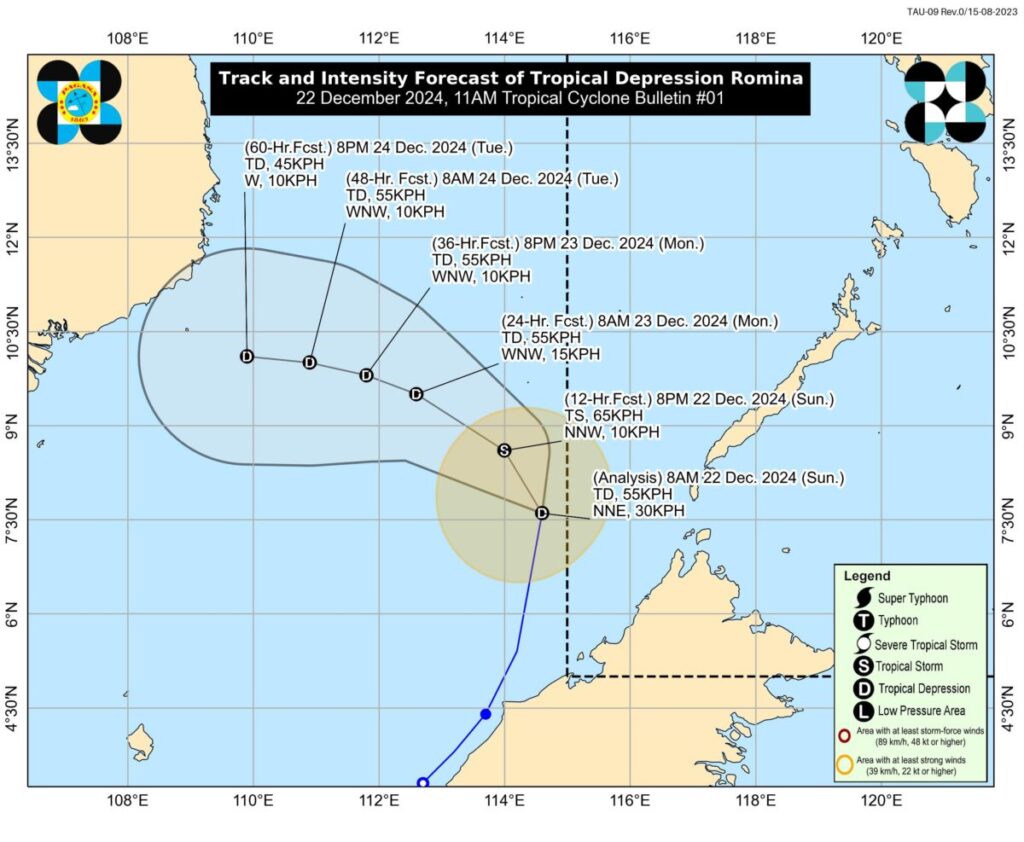
Image from Pagasa
MANILA, Philippines — Tropical Cyclone Wind Signal (TCWS) No. 1 was raised over Kalayaan Islands in Palawan on Sunday, December 22, as Tropical Depression Romina advanced toward the southern part of the region, the state weather bureau said.
Areas under TCWS No. 1 will see intermittent rains and winds of 39 to 61 kilometers per hour (kph) within 36 hours, according to the Philippine Atmospheric, Geophysical, and Astronomical Services Administration (Pagasa).
In an 11 a.m. weather forecast, Romina was last spotted some 365 kilometers south of Pag-asa Island, Kalayaan, Palawan outside the Philippine Area of Responsibility (PAR). It was packing maximum sustained winds of 55 kph near its center, with gusts of up to 70 kph, according to Pagasa weather specialist Loriedin de la Cruz – Galicia.
READ: LPA outside PAR develops into tropical depression – Pagasa
“And its current movement is towards the north-northeast, moving at a relatively fast speed of 30 kilometers per hour,” she added.
Romina
Galicia explained that although the tropical depression remains outside PAR, it was named Romina as it is expected to affect parts of the country, particularly the Kalayaan Islands in Palawan.
READ: New LPA off Mindanao may become tropical cyclone in 24-48 hrs
“Currently, aside from its effects on the Kalayaan Islands, we are also seeing rainfall that may affect the rest of Palawan province due to the track of Romina,” she said.
“Based on our forecast track, we can see that it will slightly shift toward the north-northwest in the coming hours. It is expected to approach the southern or western part of the Kalayaan Islands and may intensify further before it eventually moves away from our landmass and exits our area of responsibility,” she added.
The state weather bureau is also not ruling out Romina’s brief entry in the PAR.
It may briefly reach tropical storm category within the next 12 hours before weakening into a tropical depression for the rest of the forecast period, Pagasa added.
Apart from Romina, the southeast monsoon or amihan will continue to influence weather conditions in Northern and Central Luzon, Galicia said.
The shear line, or the convergence of warm winds and cold amihan, will also bring rains in many parts of Southern Luzon, particularly its eastern section, as well as the eastern section of Visayas, she added.
