
Here are live updates for Tropical Storm Chedeng based on Pagasa advisories.
Chedeng now a typhoon–Pagasa

Chedeng maintains strength
At 11 a.m., TS Chedeng maintains its strength and moves northward over the Philippine Sea.
TROPICAL CYCLONE BULLETIN NO. 5
Tropical Storm #ChedengPH (GUCHOL)
Issued at 11:00 AM, 07 June 2023
Valid for broadcast until the next bulletin at 5:00 PM today.“CHEDENG” MAINTAINS ITS STRENGTH AS IT MOVES NORTHWARD OVER THE PHILIPPINE SEA
Fore more details, visit… pic.twitter.com/EDmcqvdWwY
— PAGASA-DOST (@dost_pagasa) June 7, 2023
TS Chedeng is estimated, based on all available data, at 1,190 km east of southeastern Luzon moving northward at 10 km/h.
It still has maximum sustained winds of 75 km/h near the center and gustiness of up to 90 km/h
Tropical Storm Chedeng is unlikely to directly bring heavy rainfall over any portion of the country in the next 3 to 5 days, a Pagasa advisory said.
Although the current forecast scenario for this tropical cyclone may result in the enhancement of the Southwest Monsoon, the timing and intensity of monsoon rains over the country (especially in the western portion) may still change due to the dependence of monsoon enhancement on the forecast movement and intensity of Chedeng and its interaction with the other weather systems surrounding it.
Chedeng slightly intensifies
TROPICAL CYCLONE BULLETIN NO. 6
Tropical Storm #ChedengPH (GUCHOL)
Issued at 5:00 PM, 07 June 2023
Valid for broadcast until the next bulletin at 11:00 PM today.“CHEDENG” SLIGHTLY INTENSIFIES WHILE MOVING WEST NORTHWESTWARD OVER THE PHILIPPINE SEA pic.twitter.com/ZgkosXosfx
— PAGASA-DOST (@dost_pagasa) June 7, 2023
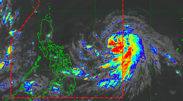
At 3:00 p.m. Wednesday, the center of Tropical Storm “CHEDENG” {GUCHOL} was estimated based on all available data at 1,160 km East of Southern Luzon (15.0°N, 133.7°E) with maximum sustained winds of 85 km/h near the center and gustiness of up to 105 km/h. It is moving west northwestward slowly.

AS of 4:40 p.m. Wednesday. | Pagasa
Chedeng intensifies into severe tropical storm
Chedeng has become a severe tropical storm, bringing maximum sustained winds of 95 kilometer per hour (km/h) near the center, gustiness of up to 115 km/h, and central pressure of 992 hPa.
Pagasa said in its advisory that the storm “still does not directly affect the country as it intensifies into a severe tropical storm.”
The location of the center of the storm is at 1,220 kilometers east of southeastern Luzon.
Severe tropical storm #ChedengPH maintains strength over PH sea
Severe Tropical Storm #ChedengPH maintained its strength while over the Philippine Sea, according to the 5 a.m. bulletin of Pagasa on Thursday, June 8.
The center of the severe tropical storm is estimated, based on all available data, to be 1,090 kilometers east of Central Luzon.
It brings maximum sustained winds of 95 kilometers per hour (km/h) near the center, gustiness of up to 115 km/h, and central pressure of 992 hPa
It is moving west northwestward at 10 km/h.
Pagasa: Severe tropical storm Chedeng intensifies
Severe Tropical Storm #ChedengPH has intensified while moving west northwestward over the Philippine sea on Thursday morning.
The location of the center of Chedeng was estimated at 1,070 kilometers east of Central Luzon.
It has maximum sustained winds of 100 kilometers per hour (km/h) near the center, gustiness of up to 125 km/h, and central pressure of 985 hPa. It is moving west northwestward at 15 km/h.
READ MORE:
Most of typhoon signals lifted as ‘Betty’ heads out of PAR