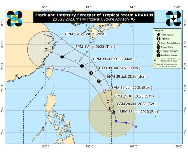
MANILA, Philippines — The tropical storm with the international name Khanun has entered the Philippine area of responsibility (PAR) and was given the local name Falcon, said the state weather bureau.
Philippine Atmospheric, Geophysical and Astronomical Services Administration (Pagasa) weather specialist Benison Estareja said Falcon entered the country’s area of responsibility at 11 p.m. on July 28.
Falcon was last seen 1,360 kilometers east of Central Luzon. It has maximum sustained winds of 65 kilometers per hour and gustiness of up to 80 kph.
It is moving west-northwestward at 15 kilometers per hour.
“This tropical cyclone will remain over the Philippine Sea and far from the landmass throughout the forecast period. Falcon may exit the PAR region between Monday afternoon and Monday evening,” said Pagasa in its 5 a.m. bulletin.
The state weather bureau added that Falcon might continuously intensify over the next three days. It may also strengthen into a typhoon on Sunday, July 30.
“The hoisting of wind signal due to Falcon over any locality in the country remains unlikely based on the current forecast scenario,” said Pagasa.
Despite this, state meteorologists still warned of occasional rain in the western sections of Luzon and Visayas which may be caused by the southwest monsoon being enhanced by tropical storm Doksuri, formerly Egay, and tropical storm Falcon.
Meanwhile, gusty conditions may prevail over the following areas due to the cyclone-enhanced southwest monsoon beginning Saturday, July 29:
- Zambales
- Bataan
- Palawan
- Occidental Mindoro
- Romblon
- most of CALABARZON
- Bicol Region
- Western Visayas
Metro Manila and nearby provinces may also be affected by gusty conditions beginning Sunday, July 30.
RELATED STORIES
Pagasa: Tropical Storm Khanun to enter PAR as Falcon early Saturday
Tropical storm Khanun maintains strength, still outside PAR