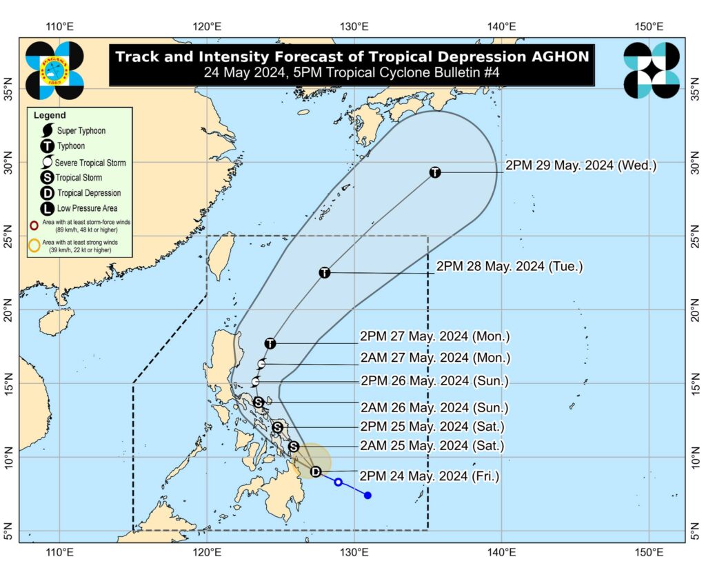
The path of TD Aghon. | Photo from Pagasa’s Facebook
MANILA, Philippines — Twenty areas nationwide are now under Tropical Cyclone Wind Signal No. 1 due to Tropical Depression (TD) Aghon, the state weather bureau said on Friday afternoon.
According to the Philippine Atmospheric, Geophysical and Astronomical Services Administration (Pagasa) in its 5:00 p.m. update, the areas below may experience wind speeds of up to 39-61 kilometers per hour (kph):
READ:
LIVE UPDATES: Tropical Depression Aghon
TD ‘Aghon,’ year’s first cyclone, intensifies
Luzon
- Sorsogon
- Albay
- Catanduanes
- Camarines Sur
- Camarines Norte
- Masbate including Ticao Island, Burias Island
- Quezon (Calauag, Guinayangan, Lopez, Buenavista, Catanauan, Mulanay, San Narciso, San Francisco, San Andres, Tagkawayan)
Visayas
- Eastern Samar
- Samar
- Northern Samar
- Leyte
- Southern Leyte
- Biliran
- Cebu (San Remigio, Tabogon, City of Bogo, Medellin, Daanbantayan, Borbon) including Camotes Islands and Bantayan Islands
- Bohol (Pres. Carlos P. Garcia, Bien Unido, Trinidad, Anda, Candijay, Ubay, Mabini, Alicia, San Miguel, Talibon)
Mindanao
- Dinagat Islands
- Surigao del Norte including Siargao and Bucas Grande Islands
- Surigao del Sur
- Agusan del Sur (Sibagat, City of Bayugan, Prosperidad, San Francisco, Rosario, Bunawan, Trento)
- Agusan del Norte
Pagasa said that the center of TD Aghon was last located at 135 kilometers (km) northeast of Hinatuan, Surigao del Sur, and it was moving west-northwestward at 30 kph.
It had maximum wind speeds of 55 kph near the center and gusts of 40 kph.
READ: Tropical Depression Aghon slightly intensifies; 18 areas under Signal no. 1
“On the track forecast, Aghon is forecast to make landfall over the southern portion of Eastern Samar or Dinagat Islands by tomorrow morning as a tropical storm,” Pagasa said.
TD Aghon is the first typhoon to enter the Philippines this year and the rains and cooler temperature it brings are a welcome respite to a country that has been ravaged by extreme heat in the past months due to the prolonged El Niño.