
Image from DOST / Pagasa
MANILA, Philippines — Tropical Storm Kristine (international name: Trami) slightly intensified as it moved over the Bicol region.
The Philippine Atmospheric, Geophysical and Astronomical Services Administration (Pagasa) reported on Tuesday afternoon, October 22, 2024, that Tropical Cyclone Wind Signal (TCWS) No. 1 and 2 had been issued in various areas across the country.
READ MORE:
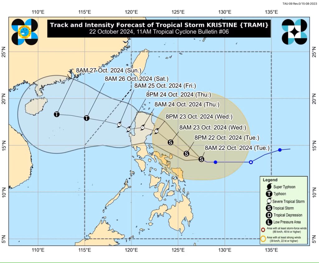
Pagasa, in its Tuesday afternoon update, said Kristine was last spotted some 390 kilometers east of Daet, Camarines Norte and moving west-northwest at 15 kilometer per hour (kph).
Its maximum wind speed increased from 65 kilometers per hour (kph) near the center to 75 kph, while gustiness likewise increased from 80 kph to 90 kph.
Kristine: Areas under signal no. 2
Catanduanes, Eastern portion of Camarines Norte (Basud, Daet, Talisay, Vinzons, Paracale, Mercedes)
Eastern portion of Camarines Sur (Caramoan, Presentacion, Garchitorena, Tinambac, Siruma, Lagonoy, Goa, San Jose, Saglay, Tigaon)
Eastern portion of Albay (Rapu-Rapu, Bacacay, City of Tabaco, Malilipot, Malinao, Tiwi)
Eastern portion of Sorsogon (Barcelona, Gubat, Prieto Diaz)
Kristine: Areas under signal no. 1
Luzon
Ilocos Norte
Ilocos Sur
La Union
Pangasinan
Apayao
Kalinga
Abra
Mountain Province
Ifugao
Benguet
Cagayan including Babuya Islands
Isabela
Quirino
Nueva Vizcaya
Aurora
Nueva Ecija
Tarlac
Zambales
Bataan
Pampanga
Bulacan
Metro Manila
Cavite
Laguna
Batangas
Rizal
Quezon including Polillo Islands
Occidental Mindoro including Lubang island
Oriental Mindoro
Masbate including Ticao and Burias Islands
Marinduque
Romblon
Rest of Camarines Norte
Rest of Camarines Sur
Rest of Albay
Rest of Sorsgon
Visayas
Rest of Eastern Samar
Rest of Northern Samar
Samar
Leyte
Biliran
Southern Leyte
Mindanao
Dinagat Islands
Surigao del Norte including Siargao – Bucas Grande Group
Kristine: Landfall forecast
Kristine is forecast to make a landfall over Isabela or northern Aurora on Wednesday evening, October 23, or early Thursday morning (October 24).
It is also expected to develop into a severe tropical storm before it makes a landfall.
It is expected to exit the Philippine area of responsibility by Friday, October 25.
Rough seas alert!
A gale warning is raised over the northern and eastern seaboards of Luzon, southern seaboard of Southern Luzon, and the eastern seaboard of the Visayas.
Pagasa warned that “[s]ea travel is risky for all types or tonnage of vessels.”