
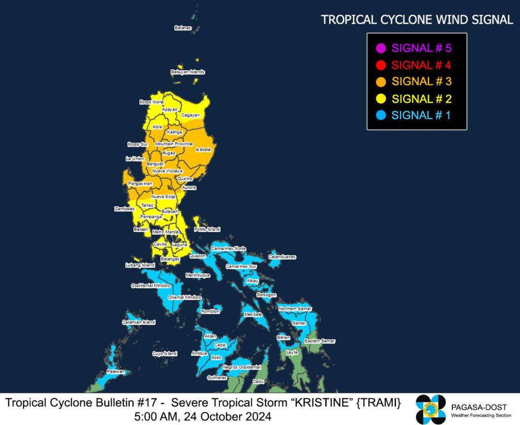
A look at the areas with storm signals hoiisted due to severe tropical storm Kristine. | Pagasa image
Due to the effects brought by severe tropical storm Kristine (International name:TRAMI), northern parts of Cebu remain under signal no. 1 as of 5 a.m. on Thursday, October 24, 2024.
Based on the 5 a.m. bulletin of Pagasa, tropical cyclone wind signal no.. 1 remains hoisted in Medellin, Daanbantayan, San Remigio, City of Bogo, Tabuelan, Tabogon, and Bantayan Islands.
READ MORE:
The center of Kristine, as of 4 a.m. on Thursday, was estimated in the vicinity of Tumauini, Isabela, packing maximum sustained winds of 95 km/h near the center, gustiness of up to 160 km/h, and central pressure of 985 hPa
Kristine is moving west northwestward at 15 km/h.
Kristine: Signal no. 3
Signal no. 3 is declared under these areas: (Wind threat: Storm-force winds)
Luzon:
The southern portion of Cagayan (Peñablanca, Tuguegarao City, Enrile, Solana, Iguig, Tuao), Isabela, Quirino, Nueva Vizcaya, Kalinga, Mountain Province, Ifugao, the southern portion of Abra (Malibcong, Licuan-Baay, Sallapadan, Daguioman, Bucloc, Boliney, Tubo, Luba, Manabo, Bucay, Villaviciosa, Pilar, San Isidro, Peñarrubia), Benguet, the northern and central portions of Aurora (Dilasag, Casiguran, Dinalungan, Dipaculao, Maria Aurora, Baler), the northern portion of Nueva Ecija (Carranglan, Lupao, San Jose City, Pantabangan, Guimba, Santo Domingo, Talavera, Llanera, Rizal, Bongabon, Talugtug, Science City of Muñoz, Cuyapo, Nampicuan), the northern portion of Tarlac (Mayantoc, San Clemente, Camiling, Santa Ignacia, Gerona, Paniqui, Moncada, San Manuel, Anao, Ramos, Pura, Victoria), the northern portion of Zambales (Candelaria, Santa Cruz, Masinloc), Pangasinan, La Union, and the central and southern portions of Ilocos Sur (Cervantes, Quirino, Sigay, Suyo, Alilem, Sugpon, Tagudin, Santa Cruz, Salcedo, Gregorio del Pilar, San Emilio, Lidlidda, Burgos, San Esteban, Santiago, Banayoyo, Galimuyod, City of Candon, Santa Lucia, Nagbukel, Santa Maria, Narvacan)
Kristine: Signal no. 2
(Wind threat: Gale-force winds)
Luzon:
Ilocos Norte, the rest of Ilocos Sur, Apayao, the rest of Abra, the rest of Cagayan including Babuyan Islands, the rest of Aurora, the rest of Nueva Ecija, Bulacan, the rest of Tarlac, Pampanga, the rest of Zambales, Bataan, Metro Manila, Cavite, Laguna, Rizal, Batangas, the northern and central portions of Quezon (Lucena City, Pagbilao, Infanta, Tiaong, San Antonio, Candelaria, Lucban, Sampaloc, Sariaya, City of Tayabas, Mauban, Dolores, General Nakar, Real) including Polillo Islands, and Lubang Island
Kristine: Signal No. 1
(Wind threat: Strong winds)
Luzon:
Batanes, the rest of Quezon, the rest of Occidental Mindoro, Oriental Mindoro, Marinduque, Romblon, the northern portion of mainland Palawan (El Nido, Taytay, Araceli, San Vicente, Dumaran, Roxas) including Calamian Islands and Cuyo Islands, Camarines Norte, Camarines Sur, Catanduanes, Albay, Sorsogon, and Masbate including Ticao and Burias Islands
Visayas:
Aklan, Capiz, Antique including Caluya Islands, Iloilo, Guimaras, the northern portion of Negros Occidental (Pulupandan, Bacolod City, Silay City, City of Talisay, Enrique B. Magalona, Manapla, City of Victorias, Cadiz City, Sagay City, City of Escalante, Toboso, Valladolid, Bago City, Murcia, Salvador Benedicto, Calatrava), the northern portion of Cebu (Medellin, Daanbantayan, San Remigio, City of Bogo, Tabuelan, Tabogon) including Bantayan Islands, Northern Samar, Samar, Biliran, the northern portion of Eastern Samar (Oras, Can-Avid, Maslog, San Policarpo, Taft, Dolores, Jipapad, Arteche, Sulat), and the northern portion of Leyte (San Isidro, Calubian, San Miguel, Babatngon, Barugo, Tunga, Carigara, Capoocan, Leyte, Villaba, Tabango)
Kristine is forecast to cross northern Luzon over the next 12 hours and may emerge over the waters west of Ilocos Region Thursday afternoon or evening.
It will then move west northwestward over the West Philippine Sea and exit the Philippine Area of Responsibility (PAR) region on Friday afternoon, October 25.
The next tropical cyclone bulletin of Pagasa will be issued at 8 a.m.