
Track and intensity outlook of Kristine. | Pagasa
As severe tropical storm Kristine moves further away from the Philippine landmass on Friday, October 25, 2024, Pagasa said in its latest bulletin that re-entry to the Philippine Area of Responsibility (PAR) is not being ruled out.
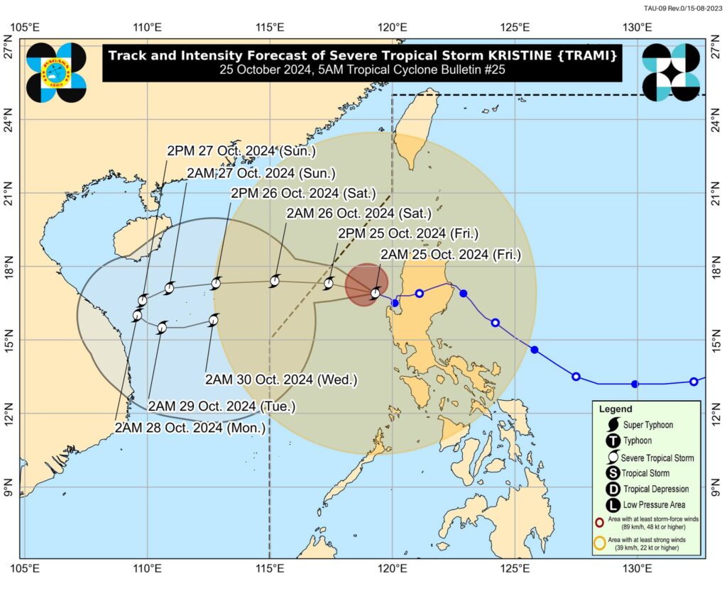
In Pagasa’s 5 a.m. bulletin on Friday, its track and intensity outlook said that Kristine is forecast to move west northwestward to westward over the next 48 hours and exit the PAR region in the afternoon.
READ MORE:
Fujiwhara effect? Kristine to return? Pagasa addresses claims
In the extended outlook, Pagasa also said there is a developing forecast situation wherein Kristine will be looping over the West Philippine Sea on Sunday, October 27, and Monday, October 28, and move generally eastward towards the general direction of the PAR region. Re-entry to the PAR is not being ruled out.

However, Pagasa said this scenario heavily depends on the behavior of a tropical cyclone east of the PAR region.
Additionally, Kristine, Pagasa said, is forecast to undergo a short period of intensification as it moves over the West Philippine Sea.
“While it is likely that the tropical cyclone will remain a severe tropical storm in the next five days, the chance for it to be upgraded into a typhoon is not ruled out,” part of the bulletin said.
Where is Kristine?
As of 4 a.m. on Friday, Kristine maintained its strength as it accelerated west northwestward over the sea west of northern Luzon.
The center of Kristine was estimated at 125 km West Northwest of Bacnotan, La Union, packing maximum sustained winds of 95 km/h near the center, gustiness of up to 115 km/h, and central pressure of 985 hPa
It was moving West northwestward at 25 km/h
KRISTINE: TROPICAL CYCLONE WIND SIGNALS
Signal No. 2:
(Wind threat: Gale-force winds)
Luzon
Cagayan including Babuyan Islands, Isabela, Quirino, Nueva Vizcaya, Apayao, Kalinga, Abra, Ifugao, Mountain Province, Benguet, Ilocos Norte, Ilocos Sur, La Union, Pangasinan, Aurora, Nueva Ecija, Tarlac, Zambales, Bataan, Pampanga, Bulacan, Metro Manila, the northern portion of Cavite (Ternate, Maragondon, Naic, Tanza, City of General Trias, Rosario, Cavite City, Noveleta, Kawit, Imus City, Bacoor City), the northern portion of Rizal (Cainta, Taytay, Angono, San Mateo, Rodriguez, Tanay, City of Antipolo, Baras, Teresa, Morong), and the northern portion of mainland Quezon (General Nakar)
Signal No. 1
(Wind threat: Strong winds)
Luzon
Batanes, the rest of Rizal, the rest of Cavite, Batangas, Laguna, the rest of Quezon including Polillo Islands, Occidental Mindoro including Lubang Islands, Oriental Mindoro, Marinduque, Romblon, the northern portion of mainland Palawan (El Nido, Taytay, Araceli, Dumaran, San Vicente) including Calamian, Cuyo, and, Kalayaan Islands, Camarines Norte, Camarines Sur, Catanduanes, Albay, the northern and central portions of Sorsogon (Castilla, Magallanes, Pilar, Casiguran, Donsol, Juban, Gubat, City of Sorsogon, Prieto Diaz, Bulan), and the northern and central portions of Masbate (City of Masbate, Uson, Dimasalang, Mobo, Cawayan, Aroroy, Balud, Mandaon, Milagros, Baleno) including Ticao and Burias Islands
Visayas
Aklan, Capiz, Antique including Caluya Islands, and the northwestern portion of Iloilo ((Lambunao, Calinog, Bingawan, Janiuay, City of Passi)