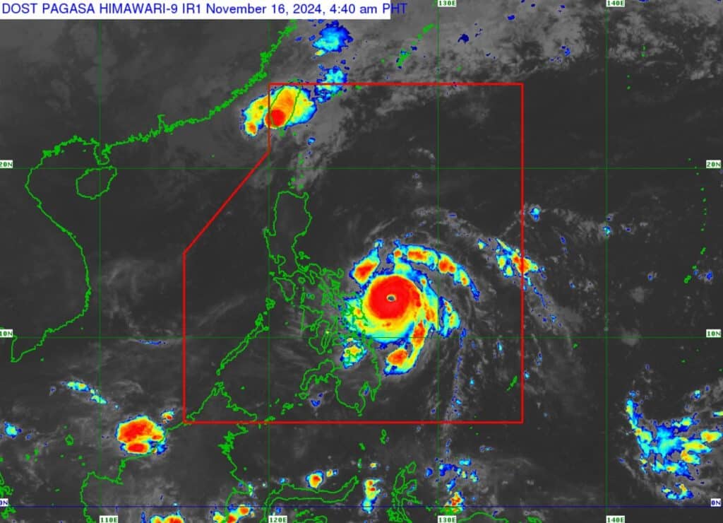
A satellite image of the location of typhoon Pepito at 4:40 a.m. Saturday, November 16, 2024, from Pagasa.
Typhoon Pepito has intensified and nears super typhoon category early Saturday, November 16, 2024, as it threatens Eastern Visayas sand Southern Luzon.
As of 4 a.m., Pagasa, in its early morning bulletin on Saturday, said Pepito now packs maximum sustained winds of 175 kilometers per hour (km/h) near the center, gustiness of up to 215 km/h, and central pressure of 940 hPa.
The location of the eye of Pepito as of 4 a.m. was 220 km east northeast of Borongan City, Eastern Samar or 305 km east of Catarman, Northern Samar.
READ MORE:
Pepito a very dangerous cyclone, warns Pagasa
Pepito is moving west northwestward at 25 km/h.
Extent of Tropical Cyclone Winds: Strong to typhoon-force winds extend outwards up to 440 km from the center of Pepito.
Tropical Cyclone Wind Signals in effect due to Pepito. | Pagasa
PEPITO UPDATE: TROPICAL CYCLONE WIND SIGNALS (TCWS) IN EFFECT
Signal no. 3
Luzon:
Catanduanes, the eastern portion of Albay (Rapu-Rapu, Bacacay, City of Tabaco, Malilipot, Tiwi, Malinao), the eastern portion of Camarines Sur (Caramoan, Presentacion, San Jose, Garchitorena, Lagonoy, Sagñay, Tigaon, Goa), and the easternmost portion of Sorsogon (Prieto Diaz)
Visayas:
The eastern portion of Northern Samar (Palapag, Laoang, Mapanas, Gamay, Lapinig, Catubig, Pambujan) and the northernmost portion of Eastern Samar (San Policarpo, Arteche, Oras, Jipapad)
Signal No.2
Luzon:
The rest of Camarines Sur, the rest of Albay, the rest of Sorsogon, Ticao Island, Camarines Norte, the easternmost portion of mainland Quezon (Tagkawayan), and Pollilo Islands
Visayas:
The northern portion of Eastern Samar (Dolores, Maslog, Can-Avid, Taft, Sulat, San Julian, City of Borongan), the northern portion of Samar (Matuguinao, Calbayog City, Santa Margarita, San Jorge, San Jose de Buan, Tarangnan, Motiong, Gandara, Jiabong, City of Catbalogan, Paranas, Hinabangan, San Sebastian, Pagsanghan), and the rest of Northern Samar
Signal No.1
Luzon:
The rest of Masbate including Burias Island, Marinduque, Romblon, the rest of Quezon, Laguna, Rizal, Cavite, Batangas, Metro Manila, Zambales, Bataan, Bulacan, Pampanga, Tarlac, Nueva Ecija, Aurora, Quirino, Nueva Vizcaya, Isabela, the central and southern portions of Cagayan (Peñablanca, Tuguegarao City, Enrile, Solana, Iguig, Tuao, Rizal, Santo Niño, Lasam, Gattaran, Baggao, Amulung, Alcala, Piat, Lal-Lo, Allacapan), Pangasinan, La Union, Ilocos Sur, Abra, the southern portion of Apayao (Conner, Kabugao, Pudtol, Flora), Kalinga, Mountain Province, Ifugao, and Benguet
Visayas:
The rest of Eastern Samar, the rest of Samar, Biliran, the northern and central portions of Leyte (Tunga, Pastrana, San Miguel, Matag-Ob, Tolosa, Palo, Calubian, Leyte, Mayorga, Julita, Carigara, Babatngon, Dagami, Jaro, San Isidro, Santa Fe, Albuera, Villaba, La Paz, Palompon, Macarthur, Tabontabon, Tanauan, Merida, Ormoc City, Isabel, Dulag, Capoocan, Alangalang, Burauen, Tabango, Tacloban City, Kananga, Barugo, Abuyog, Javier, City of Baybay, Mahaplag), the northeastern portion of Southern Leyte (Silago), the northernmost portion of Cebu (Daanbantayan, Medellin) including Bantayan Islands, and the northernmost portion of Iloilo (Carles)
Mindanao:
The northern portion of Dinagat Islands (Loreto, Tubajon)
Pepito landfall
Pepito is more likely to make landfall in the vicinity of Catanduanes Saturday night or Sunday early morning.
“However, considering the limits of the forecast confidence cone, a landfall scenario over the eastern coast of Camarines Sur, Albay, or Sorsogon during the same time frame, or along the eastern coast of Quezon or Aurora tomorrow (Sunday) afternoon or evening remains not ruled out,” Pagasa said in its bulletin.
Pagasa said Pepito will continue to intensify today and may reach super typhoon category within the next hours prior to its landfall Saturday night or early Sunday morning.
Although a slight weakening may occur after its initial passage over land, much of the weakening will occur Sunday as it passes over the landmass of Central Luzon.