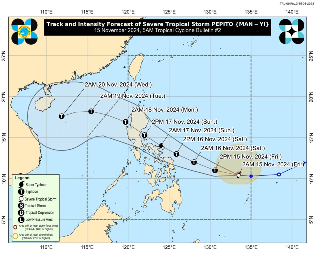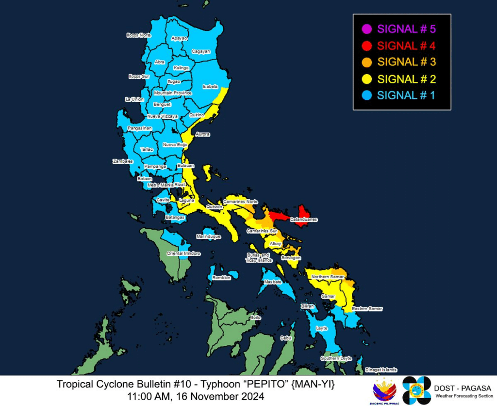
Track and intensity forecast of Pepito. | Pagasa
(UPDATED, NOV. 16, 8:17 p.m.) Pepito, which has an international name, Man-Yi, is the sixth storm in the Philippines in less than a month.
It entered the Philippine Area of Responsibility (PAR) on Thursday, November 14, 2024.
Here are the latest updates on the storm.
Bookmark this page to stay updated on Pepito’s forecast.
READ MORE:
LIST: Philippine Typhoon Names for 2024
Pepito reaching peak intensity, possible catastrophic level – Pagasa
Super Typhoon Pepito (international name: Man-yi) is approaching peak intensity and is possible to bring “catastrophic and life-threatening situation” over the northeastern Bicol region on Saturday afternoon, the Philippine Atmospheric, Geophysical and Astronomical Services Administration (Pagasa) said.
In its 2 p.m. weather update, Pagasa said that while the super typhoon is forecast to make a landfall in the vicinity of Catanduanes on Saturday night or early Sunday morning, “a landfall scenario over the eastern coast of Camarines Sur or Albay during the same time frame (if it moves slightly south of forecast track), or along the eastern coast of Quezon or Aurora tomorrow afternoon or evening remains (if it moves slightly north of forecast track) [is] not ruled out.”
Further, Pagasa added that Pepito will traverse or move near localities of Bicol Region, Central Luzon, Quezon and the southern portions of Ilocos Region and Cordillera Administrative Region.
Catanduanes under Signal No. 5 as Pepito set to make landfall
With Super Typhoon Pepito (international name: Man-yi) expected to make landfall on the island province on Saturday, Catanduanes was placed under Tropical Cyclone Wind Signal (TCWS) No. 5, the warning system’s highest alert level.
In its 2 p.m. advisory, the Philippine Atmospheric, Geophysical and Astronomical Services Administration (Pagasa) placed Pepito at 180 kilometers (kms) east-southeast of Virac, Catanduanes – with winds of up to 195 kms per hour (kph) and gusts of up to 240 kph.
State meteorologists said the super typhoon was maintaining its west-northwestward path at 20 kph, with a landfall on Catanduanes imminent on either Saturday evening (Nov. 16) or Sunday early morning (Nov. 17).
Super Typhoon Pepito: Signal No. 4 up in parts of Bicol Region
Super Typhoon Pepito (international name: Man-yi) prompted the national weather agency to raise Tropical Cyclone Wind Signal (TCWS) No. 4 over parts of the Bicol Region on Saturday morning.
The Philippine Atmospheric, Geophysical and Astronomical Services Administration (Pagasa) said in its 11 a.m. tropical cyclone update that Pepito carries maximum sustained winds of up to 185 kilometers per hour (kph) and gustiness of up to 230 kph.
Super Typhoon Pepito was last spotted 185 kilometers (km) east of Catarman, Northern Samar, or 250 km east of Juban, Sorsogon. It was heading west-northwestward at 25 kph.
Storm surge in Catanduanes
PEPITO NOW A SUPER TYPHOON
Pepito: Storm surge floods coastal areas in Bicol Region
A storm surge triggered by strong winds from the approaching Typhoon Pepito (international name: Man-yi) flooded some coastal areas of provinces in the Bicol Region.
Reports of storm surge and flooding in some towns of Albay and Catanduanes surfaced on Saturday morning, November 16, with several videos of the event circulating on social media.
In Tiwi, Albay, raging flash floods swept through the coastal villages of Mayong, Maynonong, Lourdes, Bariis, and Baybay at around 6:10 a.m.
PEPITO 8 a.m. update Saturday
Pepito now packs maximum sustained winds of 175 km/h near the center and gustiness of up to 215 km/h.
It is moving northwestward at 25 km/h.
The center of the eye of Typhoon Pepito is estimated at 235 kilometers east of Catarman, Northern Samar.
Pagasa update on Pepito
Pepito update: Signal no. 1 in northernmost Cebu
Pepito nears super typhoon category
Typhoon Pepito has intensified and nears super typhoon category early Saturday, November 16, 2024, as it threatens Eastern Visayas sand Southern Luzon.
As of 4 a.m., Pagasa, in its early morning bulletin on Saturday, said Pepito now packs maximum sustained winds of 175 kilometers per hour (km/h) near the center, gustiness of up to 215 km/h, and central pressure of 940 hPa.
The location of the eye of Pepito as of 4 a.m. was 220 km east northeast of Borongan City, Eastern Samar or 305 km east of Catarman, Northern Samar.
TYPHOON “PEPITO” FURTHER INTENSIFIES
If Pepito shifts, north Cebu may see Signal No. 1 — Pagasa Mactan
Northern Cebu could experience Tropical Cyclone Wind Signal No. 1 if Typhoon Pepito’s track deviates southward from its current forecast path, the chief of the local weather bureau based in Mactan said on Friday.
However, the likelihood of such a shift remains low to moderate.
Pepito a very dangerous cyclone, warns Pagasa
The state weather bureau on Friday warned the public that Pepito (international name Man-yi), which has strengthened into a typhoon, poses a significant threat as a highly dangerous tropical cyclone.
“The next 24 hours are critical. Pepito moves really fast at 30 kph (kilometers per hour) Lubhang mapanganib ito (It’s very dangerous),” Philippine Atmospheric, Geophysical and Astronomical Services Administration (Pagasa) Administrator Nathaniel Servando said in a briefing before noon.
The typhoon packs maximum sustained winds of 130 kph near the center and gustiness of up to 160 kph. It could reach the super typhoon category prior to making a landfall on Saturday night or early Sunday.
Pepito: Signal No. 2 up in Northern and Eastern Samar
MANILA, Philippines — Tropical Cyclone Wind Signal No. 2 is raised in Northern and Eastern Samar due to Typhoon Pepito (international name: Man-yi).
Pepito gathered more strength and reached the typhoon category at 650 kilometers east of Guiuan, Eastern Samar, on Friday morning, the Philippine Atmospheric, Geophysical and Astronomical Services Administration (Pagasa) said in its 11 a.m., November 15, bulletin.
Pepito, which entered the Philippine area of responsibility (PAR) on Thursday night as a severe tropical storm, currently packs maximum sustained wind speeds of 130 kilometers per hour (kph) and a gustiness of up to 160 kph, based on the latest advisory.
READ full story here.
Pepito: Sixth storm in less than a month in PH
Pepito to hit land at peak intensity, to become typhoon in 12 hours
MANILA, Philippines — The state weather bureau said that Severe Tropical Storm Pepito (international name: Man-yi) had further intensified and was nearing typhoon status early Friday morning.
Pepito “is forecast to intensify into a typhoon within the next 12 hours” and gain more strength to become a super typhoon by Saturday evening, November 16, said the Philippine Atmospheric, Geophysical and Astronomical Services Administration (Pagasa) in its 5 a.m. weather bulletin.
Pagasa also said Pepito may make landfall at peak intensity.
READ full story here.
Storm surge warning due to Pepito
A MODERATE to HIGH risk of storm surge may occur within the next 48 hours. There is a possibility inundation due to rising sea water along with high waves in the low-lying coastal communities in some municipalities in the provinces of:
Estimated storm surge heights: 1-2 meters
ALBAY (BACACAY, CITY OF TABACO, LEGAZPI CITY, MALILIPOT, MALINAO, MANITO, RAPU-RAPU, SANTO DOMINGO (LIBOG), TIWI),
CAMARINES SUR (SAGÑAY, TIGAON),
EASTERN SAMAR (ARTECHE, BALANGKAYAN, CAN-AVID, CITY OF BORONGAN, DOLORES, HERNANI, LLORENTE, MAYDOLONG, ORAS, SALCEDO, SAN JULIAN, SAN POLICARPO, SULAT, TAFT),
NORTHERN SAMAR (ALLEN, BIRI BOBON, CAPUL, CATARMAN, GAMAY, LAOANG, LAPINIG, LAVEZARES, MAPANAS, MONDRAGON, PALAPAG, PAMBUJAN, ROSARIO, SAN ANTONIO, SAN ISIDRO, SAN JOSE, SAN ROQUE, SAN VICENTE, VICTORIA),
SAMAR (WESTERN SAMAR; CALBAYOG CITY, CITY OF CATBALOGAN, JIABONG, MOTIONG, PAGSANGHAN, PARANAS (WRIGHT), SAN SEBASTIAN, SANTA MARGARITA, TARANGNAN)
SORSOGON (BARCELONA, BULAN, BULUSAN, CASTILLA, CITY OF SORSOGON, DONSOL, GUBAT, MAGALLANES, MATNOG, PILAR, PRIETO DIAZ, SANTA MAGDALENA)
Estimated storm surge heights: 2.1-3 meters
CAMARINES SUR (CARAMOAN, GARCHITORENA, LAGONOY, PRESENTACION (PARUBCAN), SAN JOSE, SIRUMA, TINAMBAC),
CATANDUANES (BAGAMANOC, BARAS, BATO, CARAMORAN, GIGMOTO, PANDAN, PANGANIBAN (PAYO), SAN ANDRES (CALOLBON), VIGA, VIRAC)
Pepito update from Pagasa
Pepito nears typhoon category
Severe tropical storm Pepito has further intensified and is nearing typhoon category, the weather bureau said in its 5 a.m. bulletin on Friday, November 15, 2024.
Severe Tropical Storm #PepitoPH, whose international name is MAN-YI, was located 795 kilometers east of Guiuan, Eastern Samar as of 4 a.m. Friday.
Pepito carries maximum sustained winds of 110 km/h near the center, gustiness of up to 135 km/h, and central pressure of 980 hPa. It is moving westward at 25 km/h.
Man-yi (Pepito) may affect Visayas this weekend
Residents in the Visayas region are advised to regularly monitor weather updates as Tropical Storm Man-yi makes its way towards the Philippines.
Man-yi is expected to enter the Philippine Area of Responsibility on Thursday evening, November 14, the state weather bureau said.
It will then be assigned the local name Pepito.
However, latest forecast models from the Philippine Atmospheric Geophysical and Astronomical Services Administration (Pagasa) showed that the storm may likely bring damp weather in the Visayas, particularly in the Eastern and Samar side.
As a result, Cebu may also experience light to moderate rains beginning this weekend, said Romeo Aguirre, weather specialist at Pagasa-Mactan.
‘Man-yi’ may enter PAR as ‘Pepito’ Thursday night
As super typhoon Ofel makes its way to northern Luzon, Tropical Storm ‘MAN-YI’ is expected to enter the Philippine Area of Responsibility (PAR) on Thursday night, Pagasa said.
In its 11 a.m. bulletin on Thursday, Pagasa said Man-yi, which will be named Pepito when in enters PAR, is estimated at 1,375 kilometers east of northeastern Mindanao.
Pagasa said Man-yi may enter the PAR region Thursday evening.
Subscribe to our regional newsletter
Disclaimer: The comments uploaded on this site do not necessarily represent or reflect the views of management and owner of Cebudailynews. We reserve the right to exclude comments that we deem to be inconsistent with our editorial standards.


