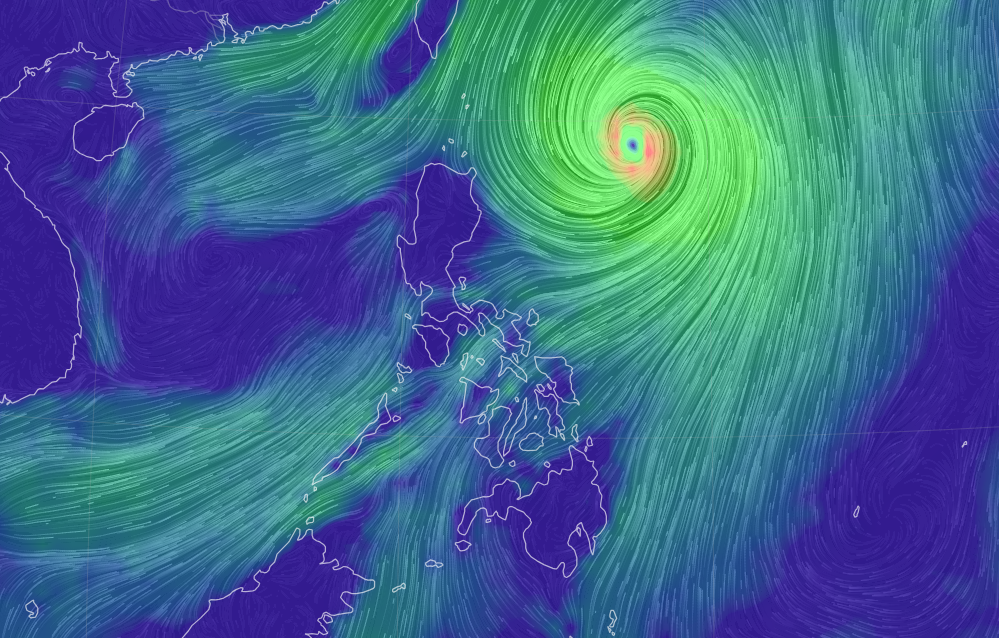
(UPDATED 12 noon., Wednesday, October 4, 2023) Live updates of Typhoon Jenny (International name: Koinu). (please refresh for latest update)
Typhoon Jenny accelerates towards Taiwan
Typhoon Jenny, which has an international name Koinu, maintained its strength and is accelerating west northwestward towards Taiwan.
This is based on the latest bulletin of Pagasa at 11 a.m. on Wednesday, October 4, 2023.
The location of the center of the eye of Typhoon Jenny was estimated at 210 kilometers northeast of Itbayat, Batanes.
Typhoon Jenny maintains strength
Typhoon Jenny (International name Koinu) maintained its strength over the Philippine Sea based on the 5 a.m. bulletin of Pagasa on Tuesday, October 3, 2023.
Jenny packs maximum sustained winds of 165 kilometers per hour (km/h) near the center, gustiness of up to 205 km/h, and central pressure of 945 hPa.
Typhoon Jenny intensifies
Typhoon Jenny, which has an international name of Koinu, has intensified, the Philippine Atmospheric, Geophysical and Astronomical Services Administration (Pagasa) said in its 11 a.m bulletin on Monday, October 2, 2023.
Typhoon Jenny now packs maximum sustained winds of 140 kilometers per hour (km/h) near its center, which is located 600 kilometers sast of Calayan, Cagayan as of 10 a.m. on Monday.
Typhoon Jenny
Jenny is now a typhoon, according to the latest bulletin of the Philippine Atmospheric, Geophysical, and Astronomical Services Administration (Pagasa).
Typhoon Jenny, which has an international name Koinu, was located 675 kilometers (km) east of Aparri, Cagayan as of 3 a.m. on Monday, October 2, 2023.
Severe Tropical Storm Jenny intensifies
Severe Tropical Storm Jenny has intensified Sunday afternoon while swirling towards Northern Luzon, which prompted the Philippine Atmospheric, Geophysical and Astronomical Services Administration (Pagasa) to raise Tropical cyclone Wind Signal No. 1 over Batanes.
In its 5 p.m. update, Pagasa reported that Jenny was spotted some 760 kilometers east of Aparri, Cagayan as it increased its maximum wind speed from 95 kilometers per hour (kph) to 100 kph near the center and gustiness from 115 kph to 125 kph while moving northwest at 15 kph.
Tropical Storm Jenny may turn into a typhoon
The state weather bureau is expecting raise wind signals over portions of the country by Sunday night or early Monday.
This is because Tropical Storm Jenny (International name: Koinu) is expected to intensify into a severe tropical storm on Sunday evening and to likely develop into a typhoon by Monday, according to the Philippine Atmospheric, Geophysical and Astronomical Services Administration (Pagasa).
Tropical Storm Jenny’s current path likely to spare PH from direct impact
If Tropical Storm (TS) Jenny maintains its current trajectory, it will not make direct landfall in the country, the Philippine Atmospheric, Geophysical and Astronomical Services Administration (Pagasa) said on Saturday.
The weather agency projected that Jenny will move northwestward through Monday.
Tropical Depression Jenny to strengthen habagat
Tropical Depression (TD) Jenny will strengthen the southwest monsoon or habagat but it will not directly affect the country.
This is according to the Philippine Atmospheric, Geophysical and Astronomical Services Administration (Pagasa) on Friday, September 29.
