Severe Tropical Storm Jenny intensifies; Signal No. 1 in Batanes
pagasa.dost
MANILA, Philippines – Severe Tropical Storm Jenny has intensified Sunday afternoon while swirling towards Northern Luzon, which prompted the Philippine Atmospheric, Geophysical and Astronomical Services Administration (Pagasa) to raise Tropical cyclone Wind Signal No. 1 over Batanes.
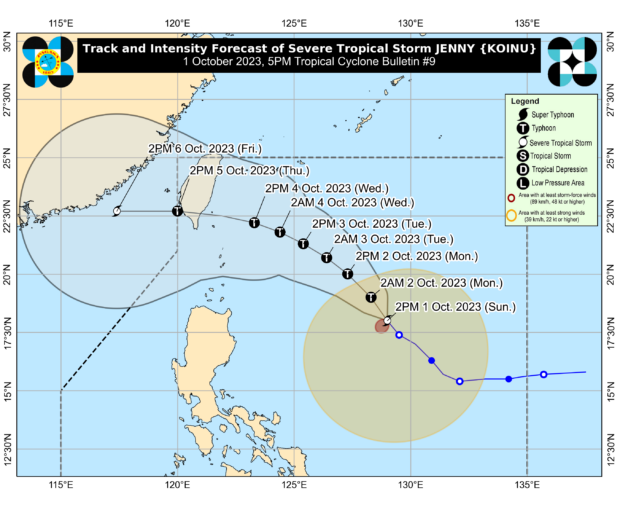
In its 5 p.m. update, Pagasa reported that Jenny was spotted some 760 kilometers east of Aparri, Cagayan as it increased its maximum wind speed from 95 kilometers per hour (kph) to 100 kph near the center and gustiness from 115 kph to 125 kph while moving northwest at 15 kph.
Cloudy skies and rain
Cloudy skies, scattered rain showers and thunderstorms due to the trough or extension of the weather disturbance will prevail in Cagayan, Isabela, Aurora, Quezon and the Bicol region.
The same conditions are expected in the Visayas, Mimaropa (Mindoro, Marinduque, Romblon, Palawan), BARMM and Zamboanga Peninsula due to the southwest monsoon or “habagat.”
Partly cloudy skies to cloudy skies with isolated rain showers and thunderstorms are likewise expected in Metro Manila and the rest of the country due to Jenny’s trough, as well as localized thunderstorms.
Flood, landslide alert
Pagasa warned residents of rain-affected ares to watch out for possible flash floods and landslides and take the needed precautions.
“Forecast rainfall are generally higher in elevated or mountainous areas. Under these conditions, flooding and rain-induced landslides are possible especially in areas that are highly or very highly susceptible to these hazards as identified in hazard maps and in localities that experienced considerable amounts of rainfall for the past several days,” Pagasa said in its sunday afternoon update.
Jenny’s track
“On the track forecast, Jenny will traverse over the southern portion of Taiwan on Wednesday evening or Tuesday morning before emerging the eastern waters of Taiwan and exiting the PAR (Philippine area of responsibility) on Thursday afternoon or evening,” the state weather bureau said.
“However, a landfall or close approach scenario over Extreme Northern Luzon is still not ruled out […] and may reach typhoon category tonight,” it added.
RELATED STORIES
Pagasa may raise wind signals on Monday as Tropical Storm Jenny may turn into a typhoon
Tropical Storm Jenny’s current path likely to spare PH from direct impact
Tropical Depression Jenny: No direct effect on PH, but it will strengthen habagat
Disclaimer: The comments uploaded on this site do not necessarily represent or reflect the views of management and owner of Cebudailynews. We reserve the right to exclude comments that we deem to be inconsistent with our editorial standards.