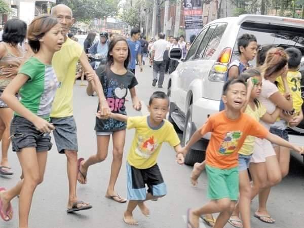
[FILE PHOTO] QUAKE PANIC Residents in Cebu City run scared as reports of a tsunami swept the city after a 6.9-magnitude earthquake shook the Central Visayas metropolis on Monday, February 6, 2012. The 2012 earthquake’s epicenter was placed near Tayasan town in Negros Oriental. The Philippines lies in the Pacific “Ring of Fire” and is prone to earthquakes and volcanic eruptions. [FILE PHOTO AFP]
CEBU CITY, Philippines — It has been over a decade since Cebu City was gripped by a tsunami scare that eventually made its way to history books.
And the real story behind the ‘Chona Mae’ hoax, including as to who the real ‘Chona Mae’ is, has remained a mystery.
But what is certain in the ‘Chona Mae’ fiasco was how scaremongering can lead to disastrous results.
It was ‘fake and alarmist news’ at its peak, some Cebuanos recalled as images of the crowd rushing to uptown Cebu City, and congested roads circulated online again to commemorate, mostly in jest, about ‘Chona Mae’.
While ‘Chona Mae’ may be a sham, the events leading to it are not. Here are some facts behind Cebu’s infamous tsunami scare.
The 6.9-magnitude earthquake
On February 6, 2012, at 11:49 a.m., a 6.9-magnitude earthquake struck the islands of Negros and Cebu.
Its epicenter was located approximately 72 kilometers north of Dumaguete City in Negros Oriental.
The thrust-fault quake was also the strongest that hit Cebu that year, according to the Philippine Institute of Volcanology and Seismology (Phivolcs).
Several provinces in Western Visayas also felt the tremors.
Meanwhile, destructive intensities, which measured Intensity VIII, were also recorded in the towns of Tayasan, Vallehermoso, Jimalalud, La Libertad, and Guihulngan, Negros Oriental.
Tsunami-alert
There was indeed a tsunami alert issued right after the earthquake.
Phivolcs, in an entry dated 2017, stated that they released a level two tsunami alert for areas facing Tañon Strait, the body of water that separates Cebu and Negros islands.
These covered the eastern seaboard of Negros and the western seaboard of Cebu.
While panic spread throughout Cebu City, tsunami waves as high as five meters reportedly hit Barangays Martilo, Pisong, and Magtalisay in La Libertad, Negros Oriental, said Phivolcs.
The coasts of Negros Oriental from San Jose to Vallehermoso and Cebu from Badian to Barili were also affected by the tsunami waves.
Fortunately, there were no widespread damages brought by the tsunami.
Fatalities, damages
Cebu was spared from the disastrous impact of the 6.9-magnitude earthquake. Negros, on the other hand, suffered significant damages, including the loss of lives.
The quake triggered multiple landslides in Negros. Majority of the fatalities, around 100, were due to these landslides that affected Solongon, La Libertad, and Planas, Guihulngan.
Vital infrastructure such as bridges, communication, and power lines, were either destroyed or rendered unusable for days, paralyzing transportation, communication, and electrical supply.
Lessons
Earthquakes may happen at any time, and their occurrence still cannot be predicted.
Moreover, Phivolcs said that both Cebu and Negros islands are located in a ‘seismically active area’ due to the presence of earthquake generators that included the Negros and Sulu Trench, segments of the Philippine Fault in Masbate and Leyte Islands and active faults.
In turn, state seismologists constantly remind the public to practice earthquake preparedness and awareness.
References
- REMINISCENCE OF THE 2012 Ms6.9 NEGROS ORIENTAL QUAKE (archive.org)
- Asean ready to rush aid to quake victims in Visayas | Global News (inquirer.net)
- Earthquake preparedness saves lives: What to do | Inquirer News
RELATED STORIES
Japan earthquake: Death toll exceeds 100, hundreds still missing
Phivolcs: Mindoro’s 5.9 magnitude earthquake not a prelude to the ‘Big One’