
FILE PHOTOS | Courtesy of The Watchmen’s Earth and Space connection/Facebook
CEBU CITY, Philippines — The chief of the state weather bureau in Mactan said on Thursday that they had seen no scenarios yet that Severe Tropical Storm (STS) Kristine would return to the country.
Engineer Alfredo Quiblat, chief of Philippine Atmospheric, Geophysical and Astronomical Services Administration (Pagasa-Mactan), said in a phone interview that there is a scenario when STS Kristine would attempt to return to the country after it exits the Philippine Area of Responsibility (PAR).
“Naa tay scenario nga inig gawas ani niya (Kristine) sa PAR, ighuman duol-duol na didtong dapita sa Vietnam, sa Lunes (Oct. 28), naay mo emerge nga high-pressure area, mo action siya’g balik (Kristine) sa nasud or sa PAR,” Quiblat said.
(There is a scenario that after Kristine leaves PAR, when it nears Vietnam, on Monday (October 28), there will be a high pressure area that will emerge, (Kristine) will then act like it will return to the country or PAR.)
READ MORE:
Kristine gradually slowing down while moving over Northern Luzon
But he clarified that there had been no scenarios that would actually tell that STS Kristine would enter the PAR, only it would recurve.
Quiblat made this clarification to respond to the Facebook post circulating on social media by ‘The Watchmen’s Earth and Space Connection’.
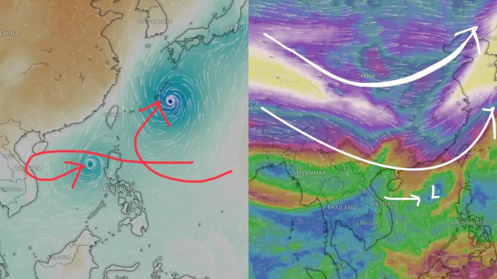
They said that they were “definitely keeping an eye on Kristine and watching the other LPA behind it.
The Euro model shows Kristine going towards China and Vietnam and then turning back around and head[ing] towards the Philippines. It shows the one behind it curving and headed towards Japan.
The Watchmen added in a separate post that the ‘jet stream would be dipping down as a trough of low pressure pushes a front through China’ and this movement would cause STS Kristine to ‘turn around’ towards the country next week.

Additionally, Quiblat also clarified that the low-pressure area (LPA) located 2,230 East of Northeastern Mindanao has a low chance to have a ‘Fujiwhara effect.’
What is the Fujiwhara effect?
The National Oceanic and Atmospheric Administration defines Fujiwhara effect as the ‘binary interaction where tropical cyclones within a certain distance of each other begin to rotate about a common midpoint.’
“Duna man puy mga speculation nga kini kunong LPA nga gibantayan nato karon…duna kuno ni siya’y Fujiwhara effect. Usa kuno ni sa mga hinungdan mga mopa-balik aning maong bagyo, pero layo ra kaayo ang scenario niana kay naa man gud tay requirement nga gisunod nga at least within 1,400 kilometers center to center sa duha nga bagyo mo epekto ang Fujiwhara effect,” Quiblat said.
(There are speculations that this LPA that we are monitoring now…it seems to have a Fujiwhara effect. This is what could make the storm return, but that is really a farfetched scenario because there are certain requirements to follow (for a fujiwhara effect to happen) that both storms should be at least 1,400 kilometers center to center for the Fujiwhare effect to happen.)
The reason why they could not declare that it is the Fujiwhara effect, he said, was because the distance between the LPA and STS Kristine is 3,000 kilometers.
“Og mahimo ning bagyo, mga 2,000-3,000 km lang gihapon ang distansya aning duha. So, walay scenario ta nga Fujiwhara effect. Kanang atong nakita lang kaning high-pressure area pero sa pagka-karon, mausab-usab man gud ni, usahay naay high-pressure area then mohinay,” Quiblat said.
(If this (LPA) will become a storm, the distance between both storms would still be 2,000-3000 km. So, there is now scenario for the Fujiwhara effect. What we see now is this high pressure area but for now, it is really changing several times, sometimes there is a high-pressure area and then it will slow down.)
Kristine will only act as if it will return but…
He clarified that as of Thursday, STS Kristine would only act like it would return to the PAR.
But should it turn back to the country, Quiblat said that STS Kristine would unlikely to maintain its strength.
“Dili pa ta katino niana kay pwede ma maintain niya (Kristine) ang Severe Tropical Storm. Pwede pa gani siya mo Typhoon kay naa man siya sa kadagatan,” he said.
(We cannot be sure of that because it (Kristine) can maintain being a Severe Tropical Storm. It even can turn into a typhoon because it is in the seas.)
“Sa pagkakaron wala pa tay scenario pa nga mobalik sa sud sa PAR. Mo action lang siya og turning back dayon posible nga mobalik napod siya padulong sa China,” he added.
(For now, we have no scenario that it will return to PAR. It will just possibly act like it will turn back but possibly it will return to head to China.)