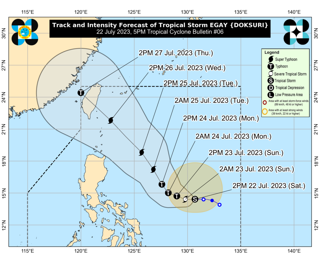
MANILA, Philippines — Tropical Storm Egay (international name: Doksuri) has slightly intensified while traversing the Philippine Sea, and the state weather bureau said it may further strengthen in the next 12 hours.
The center of Egay was last seen 685 kilometers east of Virac, Catanduanes. It was packing maximum winds of 75 kilometers per hour (kph) and gustiness of up to 90 kph while moving westward at 15 kph.
The Philippine Atmospheric, Geophysical and Astronomical Services Administration’s (Pagasa) previous bulletin showed that the weather disturbance was packing maximum winds of only 60 kph and gustiness of 80 kph at 10 a.m.
“Egay is forecast to intensify into a severe tropical storm in the next 12 hours,” said Pagasa in its bulletin issued at 5 p.m.
“Through the forecast period, this tropical cyclone will continue to steadily intensify. It may reach peak at Super Typhoon category on Tuesday (July 25) or Wednesday (July 26) while over the Philippine Sea east of Extreme Northern Luzon,” it added.
Pagasa said Egay might remain away from the Philippine landmass, but it likewise stressed that a landfall scenario over the northern portion of Northern Luzon also remained possible.
No wind signals are in effect at the moment. However, the state weather bureau warned that the southwest monsoon, which will be enhanced by Egay, will bring occasional rains in the following areas beginning Saturday (July 22) or Sunday (July 23):
- Western Visayas
- Occidental Mindoro
Meanwhile, gusty conditions may persist over the following areas in the same period due to the cyclone-enhanced southwest monsoon:
- The western and southern portions of Visayas
- The northern portions of Northern Mindanao
- Caraga
- Romblon
- Masbate
- Most of Visayas and MIMAROPA
- The northern portions of Northern Mindanao and Caraga
RELATED STORIES
LIVE UPDATES: Tropical Storm Egay
TD Egay may become a super typhoon by Monday – Pagasa
Pagasa may soon raise wind signals due to Tropical Depression Egay
