(UPDATED 11:24 p.m. Wednesday, July 26) These are updates on Typhoon Egay, which is the fifth tropical cyclone to hit the country in 2023 and the second in July.
Please refresh this page for latest updates.
‘Egay’ weakens over Luzon strait
TYPHOON EGAY, on Thursday morning, July 27, 2023, continued to weaken over the Luzon Strait west of Batanes, the Philippine Atmospheric, Geophysical and Astronomical Services Administration said.
Based on its latest bulletin, Pagasa said the eye of Typhoon Egay was estimated to be 195 kiolmeters west of Basco, Batanes.
It brings maximum sustained winds of 150 km/hour near the center, gustiness of up to 185 km/h, and central pressure of 955 hPa. It is moving northwestward at 15 km/h.
Egay is forecast to track northwestward or north northwestward over the Luzon Strait, the sea southwest of Taiwan, and the Taiwan Strait throughout the forecast period while gradually accelerating.
The typhoon may exit the Philippine Area of Responsibility (PAR) on Thursday morning or afternoon.
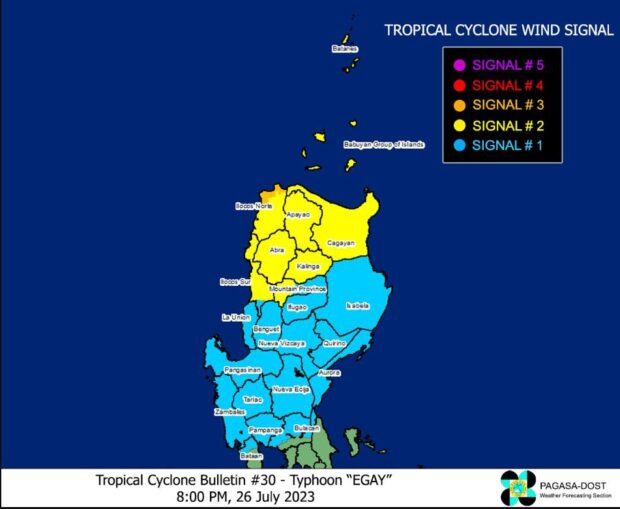
Pagasa eases typhoon signal as Egay continues to weaken
Source: DOST / Pagasa
State meteorologists on Wednesday lifted Tropical Cyclone Wind Signal (TWCS) No. 4 in parts of northern Luzon as Typhoon Egay (international name: Doksuri) continues to weaken.
To date, TCWS No. 3 is now the highest wind signal, according to the Philippine Atmospheric, Geophysical and Astronomical Services Administration (Pagasa)’s latest cyclone bulletin.
To date, only the northwestern portion of Ilocos Norte is under TCWS No. 3, where winds greater than 89 kilometers per hour (kph) to up to 117 kph could be expected in at least 18 hours.
Pagasa: Improved weather for Metro Cebu as Egay expected to exit PAR on Thursday
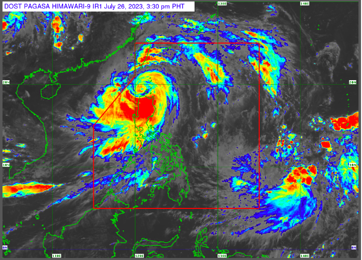
Photo screenshot from Pagasa official website
The weather in Metro Cebu and the rest of Cebu Province is expected to get better through Sunday, July 30, 2023, as Typhoon Egay is anticipated to leave the Philippine Area of Responsibility (PAR) on Thursday morning, July 27.
Engineer Al Quiblat, Philippine Atmospheric Geophysical and Astronomical Services Administration Mactan (Pagasa Mactan) chief, said the habagat or southwest monsoon, which Typhoon Egay enhanced, caused the recent downpour and strong winds felt in Metro Cebu in the past few days.
The habagat, however, is expected to weaken in the following days with Typhoon Egay’s exit in PAR.
Typhoon Egay makes landfall in Aparri, Cagayan, says Pagasa
Egay (international name: Doksuri), which has weakened into a typhoon, made landfall over Fuga Island in Aparri, Cagayan, around 3:10 a.m. on Wednesday, the state weather bureau said.
In its 5 a.m. weather bulletin, the Philippine Atmospheric, Geophysical, and Astronomical Services Administration (Pagasa) said, Egay might also make another landfall over northwestern Cagayan as it moves westward at a speed of 20 kilometers per hour (kph).
Egay was packing maximum sustained winds of 175 kph near the center and gusts of up to 240 kph, Pagasa added.
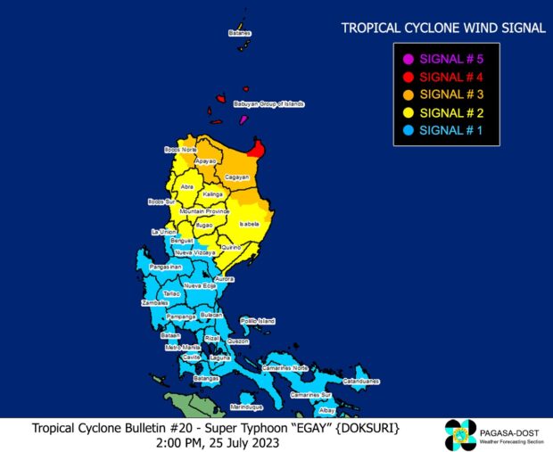
Super Typhoon Egay keeps strength; Signal No. 5 up on Babuyan’s Camiguin Island
Due to Super Typhoon Egay (international name: Doksuri), tropical Cyclone Wind Signals. Photo from Pagasa’s website
Camiguin, one of the five big islands of Babuyan, was placed under Tropical Cyclone Wind Signal (TCWS) No. 5 on Tuesday afternoon as Super Typhoon Egay (international name: Doksuri) maintained its strength while crossing the Philippine Sea.
The Philippine Atmospheric, Geophysical and Astronomical Services Administration (Pagasa) said in its 2 p.m. cyclone update that Egay was moving northwestward at 20 kilometers per hour (kph) as it was last spotted 230 kilometers east-northeast Cagayan province’s Tuguegarao City.
Egay was packing maximum sustained winds of 180 kph and gustiness of up to 230 kph, according to state meteorologists.
Egay’s strong winds and rain also made Pagasa hoist TCWS No. 4 over the northeastern part of mainland Cagayan (Santa Ana and Gonzaga) and the rest of Babuyan Islands – Babuyan Island, Calayan Island, Fuga Island, and Dalupiri Island.
Egay now a super typhoon – Pagasa
Egay has developed into the super typhoon category on Tuesday morning with four areas now under Tropical Cyclone Wind Signal No. 3, state meteorologists said.
The super typhoon is located 310 kilometers east of Tuguegarao City, Cagayan, packing maximum sustained winds of 185 kph near the center and gustiness of up to 230 kph, according to the Philippine Atmospheric, Geophysical and Astronomical Services Administration (Pagasa) said in its latest update.
“Egay is nearing its peak intensity,” Pagasa also said.
Signal No. 2 in 17 areas as Typhoon Egay intensifies — Pagasa
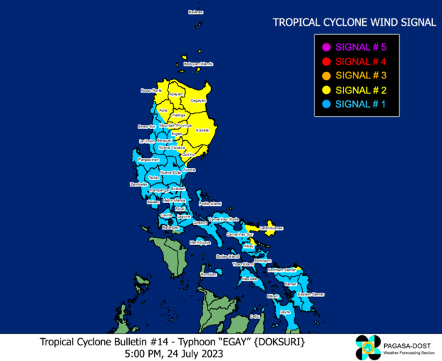
Seventeen areas are now under Tropical Cyclone Wind Signal (TCWS) Number 2 as Typhoon Egay (international name: Doksuri) steadily intensifies, the Philippine Atmospheric, Geophysical and Astronomical Services Administration (Pagasa) said in its 5:00 p.m. update.
Pagasa said the center of Egay, which was last spotted some 500 kilometers east of Baler, Aurora, has increased its maximum sustained winds from 150 kph near the center to 155 kph and gustiness from 185 kph to 190 kph while moving northwest at 10 kph.
Signal No. 1 in northern Cebu: 51 passengers stranded with suspension of sea trips
Sea trips in several ports in northern Cebu have been suspended as state meteorologists raise Storm Signal No. 1 there due to Typhoon Egay (international name: Doksuri) on Monday, July 24.
As of 11 a.m. on Monday, no ships were allowed to sail from the ports of Hagnaya in San Remigio; Santa Fe in Bantayan Island; Maya in Daanbantayan; and Medellin, the Cebu Port Authority (CPA) announces.
Trips bound to and from the ports of Poro and Consuelo in Camotes Island were also cancelled. Trips of fast craft vessels plying the Cebu – Ormoc route have also been cancelled, added CPA.
Typhoon Egay: Northern portions of Cebu under Signal no. 1
The northern portion of Cebu was placed under tropical cyclone wind signal no. 1 on Monday noon, July 24, 2023, due to typhoon Egay.
Daanbantayan, Medellin, including Bantayan Islands and Camotes Islands were placed under signal no. 1 as Egay further intensified based on the Pagasa bulletin at 11 a.m.
Egay now has maximum sustained winds of 150 kilometers per hour near the center and gustiness of up to 185 km/h while moving westward.
As of 10 a.m., the center of the eye of the storm is 525 kilometers east of Baler, Aurora.
Typhoon Egay strengthens, says Pagasa
Typhoon Egay (international name: Doksuri) has undergone rapid intensification as it moves over the Philippine sea, the Philippine Atmospheric, Geophysical and Astronomical Services Administration (Pagasa) said in its latest bulletin issued at 5 a.m. on Monday, July 24, 2023.
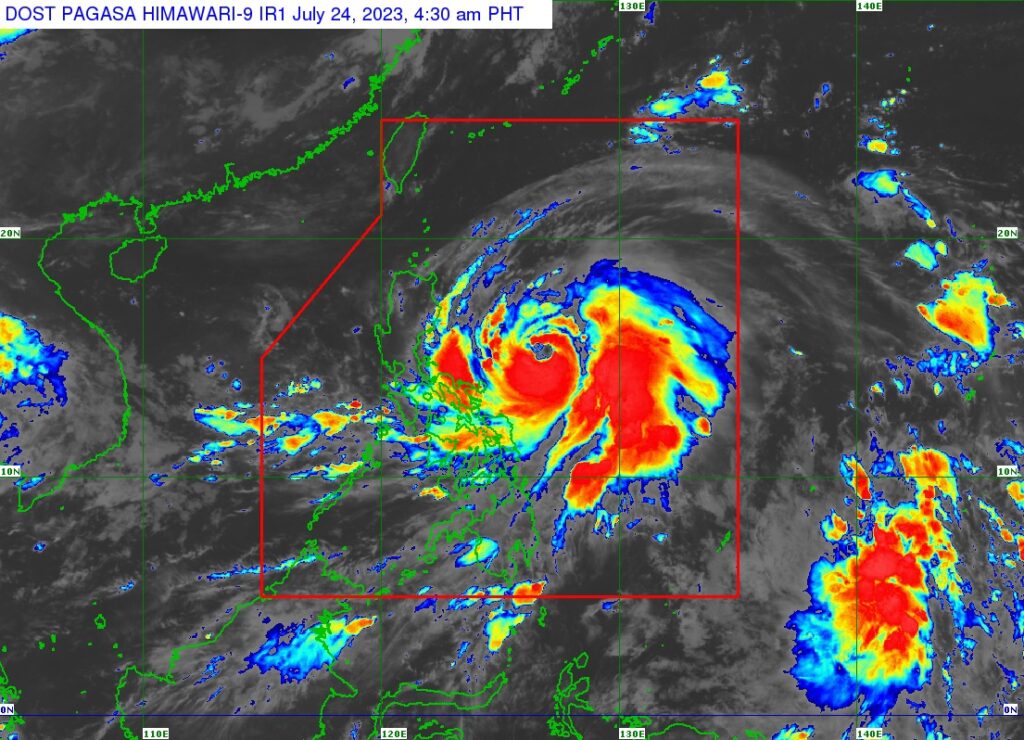
Pagasa sattelite image shows the eye of Typhoon Egay.
Typhoon Egay, as of 4 a.m. Monday, now has maximum sustained winds of 140 kilometer per hour (km/h) near the center, gustiness of up to 170 km/h, and a central pressure of 965 hPa as it moves westward at 15 km/h.
Pagasa: Egay further intensifies; Signal No. 1 in parts of 7 provinces
Tropical Cyclone Wind Signal (TCWS) Number 1 was raised in parts of seven provinces in Luzon and the Visayas Sunday afternoon as severe tropical storm Egay (international name: Doksuri) intensified further, the state weather bureau reported.
The Philippine Atmospheric, Geophysical and Astronomical Services Administration (Pagasa), in its 5:00 p.m. bulletin, said Egay was spotted some 560 kilometers east of Daet, Camarines Norte with maximum sustained winds of 110 kilometers per hour (kph) and gustiness of up to 135 kph while moving west at 10 kph.
Pagasa said that Egay is expected to enhance the southwest monsoon or “habagat” trigger rainfall in parts of Southern Luzon, Visayas, and Mindanao in the next three days.
It added that Egay is expected to intensify further into a typhoon in the next 24 hours and a super typhoon by Tuesday.
Sea travel suspended in some Bicol areas due to Egay
Sea travel in some areas in the Bicol region was suspended on Sunday, July 23, as Severe Tropical Storm Egay brought rough seas along the eastern seaboards of Luzon and Visayas.
In its 5 a.m. advisory, Coast Guard Lieutenant Esperanza Lazaro of Catanduanes Station said all small watercraft with 250 gross tonnages or less were advised not to venture into the sea because of the expected strong gale force wind.
The larger vessels were also alerted of possible big waves and rough seas.
In Camarines Sur, Coast Guard Commander Brummel Magalong also suspended the operation of the same type of vessels as Egay was also expected to affect the northern coast of the province.
Egay won’t directly affect CV, but it will make habagat stronger — Pagasa
Central Visayas can expect cloudy skies and a “windy” weather until Thursday, July 27, 2023, according to Pagasa Mactan.
“Kay ang bagyo, although layo ra diri sa atoa, wala’y direct effect. Nikusog ang habagat (southwest monsoon) so mao na’y mag dag-om ta. Expected makasinati ta’g mga occasional rains,” said Engineer Al Quiblat, chief of Pagasa Mactan in a phone interview with CDN Digital on Sunday morning, July 23.
(Because the storm, although it is far from our place, there s no direct effect. The habagat (southwest monsoon), however, grew stronger so that is why we have cloudy skies. It is expected that we can experience occasional rains.)
Quiblat said that there would be times that the public could expect moderate to heavy rains which might possibly result to floods and landslides.
Pagasa: Egay may develop into typhoon in 24 hours, super typhoon by Tuesday
Tropical storm Egay (international name: Doksuri) is forecast to develop into a typhoon within 24 hours and super typhoon on Tuesday, the Philippine Atmospheric, Geophysical and Astronomical Services Administration (Pagasa) said on Sunday.
Based on Pagasa’s 5 a.m. weather bulletin, Egay was last monitored 705 kilometers (km) east of Daet, Camarines Norte, moving 10 kilometers per hour (kph) and carrying maximum sustained winds of 85 kph and gusts of up to 105 kph.
“Ngayon pa lang itong trough o extension ng nasabing bagyo ay nagdudulot na ng mga pag-ulan sa silangang bahagi ng Southern Luzon sa Visayas at Northeastern Mindanao,” weather specialist Daniel James Villamil said in a morning press briefing.
(The typhoon’s trough or extension is already causing rains in the eastern part of Southern Luzon in the Visayas and Northeastern Mindanao.)
Tropical storm Egay slightly strengthens, may intensify in next 12 hours
Tropical Storm Egay (international name: Doksuri) has slightly intensified while traversing the Philippine Sea, and the state weather bureau said it may further strengthen in the next 12 hours.
The center of Egay was last seen 685 kilometers east of Virac, Catanduanes. It was packing maximum winds of 75 kilometers per hour (kph) and gustiness of up to 90 kph while moving westward at 15 kph.
The Philippine Atmospheric, Geophysical and Astronomical Services Administration’s (Pagasa) previous bulletin showed that the weather disturbance was packing maximum winds of only 60 kph and gustiness of 80 kph at 10 a.m.
“Egay is forecast to intensify into a severe tropical storm in the next 12 hours,” said Pagasa in its bulletin issued at 5 p.m.
Pagasa may soon raise wind signals due to Tropical Depression Egay
Tropical Cyclone Wind Signals may be raised as early as Saturday afternoon (July 22) in parts of the Bicol Region and Eastern Visayas even as Tropical Depression Egay has maintained its strength and speed.
The Philippine Atmospheric, Geophysical and Astronomical Services Administration (Pagasa) said Egay’s position was last marked 815 kilometers east of Southeastern Luzon. It was still packing maximum sustained winds of 55 kilometers per hour (kph) and gustiness of up to 70 kph as it was slowly moving west-northwestward at 10 kph.
“Posible tayong magtaas ng wind signals o babala sa hangin dito sa area ng Bicol Region and Visayas, pinakamaaga na po ngayong hapon. Maaaring mas marami pang lugar ang itaas natin ng wind signal sa mga susunod na araw,” said Pagasa’s Benison Estareja during a public weather forecast.
(We may raise wind signals in the Bicol Region and Visayas area as early as Saturday afternoon. We may raise wind signals in more areas in the next few days.)
Egay is expected to intensify into a tropical storm this Saturday and may become a super typhoon by Tuesday (July 25) or Wednesday (July 26) while over the Philippine Sea east of extreme northern Luzon.
RELATED STORIES
TD Egay may become a super typhoon by Monday – Pagasa
TD Egay: Second tropical depression in July
Disclaimer: The comments uploaded on this site do not necessarily represent or reflect the views of management and owner of Cebudailynews. We reserve the right to exclude comments that we deem to be inconsistent with our editorial standards.