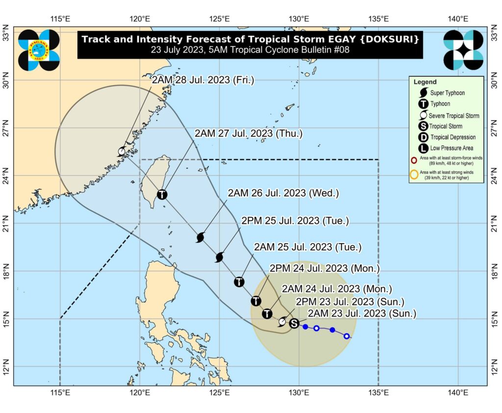
Tropical storm Egay last seen at 705 kilometers east of Daet, Camarines Norte, moving 10 kilometers per hour and carrying maximum sustained winds of 85 kph and gusts of up to 105 kph. (Photo courtesy of Pagasa)
CEBU CITY, Philippines — Central Visayas can expect cloudy skies and a “windy” weather until Thursday, July 27, 2023, according to Pagasa Mactan.
“Kay ang bagyo, although layo ra diri sa atoa, wala’y direct effect. Nikusog ang habagat (southwest monsoon) so mao na’y mag dag-om ta. Expected makasinati ta’g mga occasional rains,” said Engineer Al Quiblat, chief of Pagasa Mactan in a phone interview with CDN Digital on Sunday morning, July 23.
READ MORE: Typhoon Egay strengthens, says Pagasa
(Because the storm, although it is far from our place, there s no direct effect. The habagat (southwest monsoon), however, grew stronger so that is why we have cloudy skies. It is expected that we can experience occasional rains.)
Quiblat said that there would be times that the public could expect moderate to heavy rains which might possibly result to floods and landslides.
READ: Metro Cebu may experience rain this weekend — Pagasa
Sunday to Tuesday
Quiblat said that this weather condition would be felt starting today until Thursday.
Meanwhile, on Sunday, the winds could range from 30 to 50 kilometers per hour, and the sea condition is “moderate to rough.”
He said that it would be dangerous to small sea crafts to venture out into the sea.
“Pero wala pa ta’y gale warning nga gi-epekto diri sa [Central] Visayas ug Western Visayas. Sa Eastern Visayas, naa na’y gale warning sa Northern Samar ug Eastern Samar,” said Quiblat.
READ: LIVE UPDATES: Tropical Storm Egay
(But we still don’t have a gale warning that is issued here in [Central] Visayas and Western Visayas. At Eastern Visayas, we have gale warning in Northern Samar and Eastern Samar.)
“Ginadili na ang pagbyahe sa mga sakyanang pandagat didto (Northern and Eastern Samar). So, expected nato nga ugma, mas mukusog ang hangin, 40 to 60 kilometers per hour hangtud nana sa Tuesday,” he said.
(Sea vessels are prohibited from making trips there (Northern and Eastern Samar). So, we are expecting that tomorrow, the wind will grow stronger, 40 to 60 kilometers per hour, that will be until Tuesday.)
With this, he said that it would also be possible to issue a gale warning over Visayas and Western Visayas.
READ: Egay intensifies into severe tropical storm
Wednesday to Thursday
Pagasa Mactan foresees an improvement of the weather condition on Wednesday, July 26.
“Sa Wednesday, medyo mo improve atong weather condition. Samtang nagkalayo ang maong bagyo mo lurang-lurang ang hangin, 30 to 50 kilometers per hour,” Quiblat said.
On Wednesday, the weather condition will improve. And while the storm will go farther the winds will be calmer, 30 to 50 kilometers per hour.)
However, he said that the sea condition would still be moderate to rough until Thursday.
“Ang epekto ning maong habagat, tungod ni sa gipakusog sa bagyo nga si Egay, adunay category na karon nga tropical storm,” he said.
(The effect of our southwest monsoon, because it was made stronger by the storm Egay, we now have a category that is called tropical storm.)
Egay’s location is 725 kilometers East of Daet, Camarines Norte.
READ: Pagasa: Egay may develop into typhoon in 24 hours, super typhoon by Tuesday
Tropical Storm Egay to landfall in Taiwan
Quiblat said that Egay would be expected to move in a west-northwest direction with a speed of 10 kilometers per hour.
“Mao na iyang general direction, and expected next 12 hours mas mukusog pa into severe tropical storm samtang naa pa siya sa kadagatan sa Philippine Sea,” he said.
(This is its general direction, and it is expected in the next 12 hours that this will grow stronger into a severe tropical storm while it is still in the seas of the Philippine Sea.)
He also said that in the next 24 hours, Egay would be expected to become a typhoon and onwards.
He even said that it could possibly become “super typhoon” in its general direction on the way to “Taiwan area.”
“Mao ni atoang main track. Expected molandfall didto (Taiwan) on July 27, Thursday,” Quiblat said.
(This is our main track. It is expected to landfall there (Taiwan) on July 27, Thursday.)
READ: Egay may become a super typhoon by Monday, threatening Sona
Pagasa: Egay to leave PAR Thursday
Moreover, Egay would be expected to leave the Philippine Area of Responsibility on Thursday evening or Friday morning, he added.
“Kaning maong bagyo, naay chance nga posibleng motipas ang iyahang lihok from our main track, mo igo didtong dapita sa extreme northern portion of Luzon,” he said.
(This storm, there is a chance that it will possibly change from its main track and could hit the areas in the extreme portion of Luzon.)
Quiblat assured that the typhoon would not directly hit Central Visayas, but the southwest monsoon would be what they would be monitoring in Central and Western Visayas.
However, he said that in the next 24 hours, they could possibly issue a “tropical cyclone wind signal” in the Eastern Visayas.
Quiblat encouraged the public to check the updates of Pagasa, especially in the thunderstorm and heavy rainfall advisories among others. He also advised the public to listen to the advisories of the local disaster manager.
RELATED STORIES
Metro Cebu may experience rain this weekend — Pagasa
Work, classes suspended on July 24 due to Egay, transport strike
/dbs