Earth Nullschool
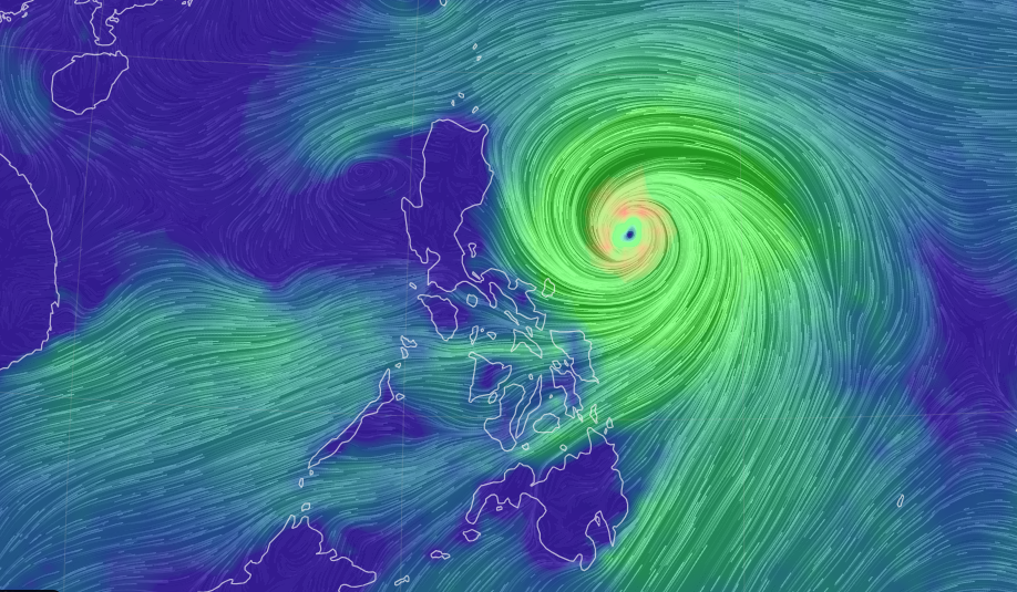
Typhoon Egay (international name: Doksuri) has undergone rapid intensification as it moves over the Philippine sea, the Philippine Atmospheric, Geophysical and Astronomical Services Administration (Pagasa) said in its latest bulletin issued at 5 a.m. on Monday, July 24, 2023.
Typhoon Egay, as of 4 a.m., now has maximum sustained winds of 140 kilometer per hour (km/h) near the center, gustiness of up to 170 km/h, and a central pressure of 965 hPa as it moves westward at 15 km/h.
READ: LIVE UPDATES: Tropical Storm Egay
The center of the eye of typhoon Egay was at 565 kilometers east of Baler, Aurora.
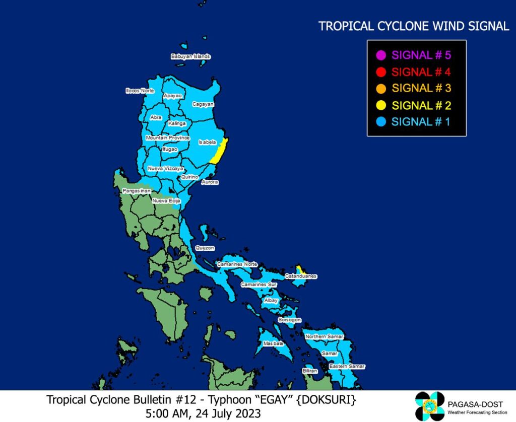
Tropical cyclone wind signal no. 1 is in effect in the following areas:

Pagasa
LUZON:
Batanes, Cagayan including Babuyan Islands, the rest of Isabela, Quirino, Nueva Vizcaya, Apayao, Kalinga, Abra, Mountain Province, Ifugao, Benguet, Ilocos Norte, Ilocos Sur, La Union, the northern portion of Pangasinan (Natividad, San Nicolas, San Quintin, Sison, Pozorrubio, San Manuel, San Fabian, Anda, Bolinao, San Jacinto, Manaoag, Laoac, Binalonan, Asingan, Tayug, Santa Maria, Umingan, Dagupan City, Mangaldan), Aurora, the northern and eastern portions of Nueva Ecija (Carranglan, Bongabon, Gabaldon, Pantabangan, Lupao, San Jose City), the northern and southeastern portions of Quezon (Pitogo, San Andres, Buenavista, San Francisco, Calauag, Infanta, Lopez, Catanauan, Mulanay, Guinayangan, Unisan, General Luna, Plaridel, Quezon, Alabat, Padre Burgos, Macalelon, Mauban, General Nakar, Perez, Agdangan, Gumaca, Atimonan, Real, San Narciso, Tagkawayan) including Polillo Islands, Camarines Norte, Camarines Sur, the rest of Catanduanes, Albay, Sorsogon, and Masbate.
VISAYAS:
Northern Samar, Eastern Samar, Samar and Biliran.
Tropical cyclone wind signal no. 2 is in effect in these areas:
LUZON:
The southeastern portion of Isabela (Palanan, Dinapigue) and northeastern portion of Catanduanes (Pandan, Bagamanoc, Panganiban, Viga, Gigmoto).

Pagasa
May intensify into super typhoon
Egay may also enhance the Southwest Monsoon, bringing occasional to monsoon rains over the western portions of Central Luzon, Southern Luzon, and Visayas in the next three days, Pagasa said.
Egay and the enhanced Southwest Monsoon may also bring gusty conditions over the following areas not under any Wind Signal, especially in coastal and upland/mountainous areas exposed to winds:
•Today: CALABARZON, MIMAROPA, Visayas, and the northern portions of Zamboanga Peninsula, Northern Mindanao, and Caraga.
•Tomorrow: Luzon, Visayas, Zamboanga Peninsula, Basilan, Sulu, Tawi-Tawi, and the northern portion of Northern Mindanao and Dinagat Islands.
•Wednesday: Luzon and Visayas.
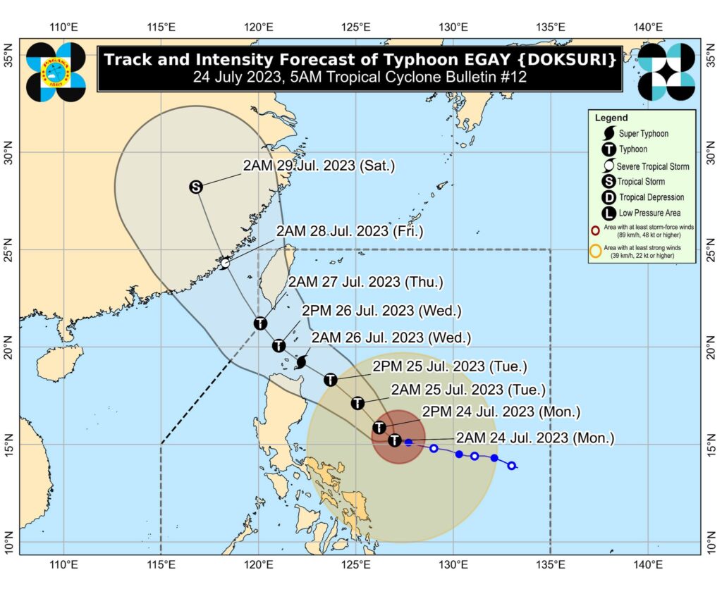
Egay is forecast to continue intensifying and reach super typhoon category by late tomorrow or on early Wednesday.
However, should the track forecast shift closer to the landmass of Luzon, the typhoon may peak at an intensity just below STY threshold.
Nevertheless, EGAY is forecast to become a very strong typhoon. A weakening trend may begin by Wednesday afternoon or evening as it enters the cooler waters southwest and west of Taiwan.
The next tropical cyclone bulletin will be issued at 11:00 AM today.
Disclaimer: The comments uploaded on this site do not necessarily represent or reflect the views of management and owner of Cebudailynews. We reserve the right to exclude comments that we deem to be inconsistent with our editorial standards.
