



EXPLAINER: How storms form and strengthen
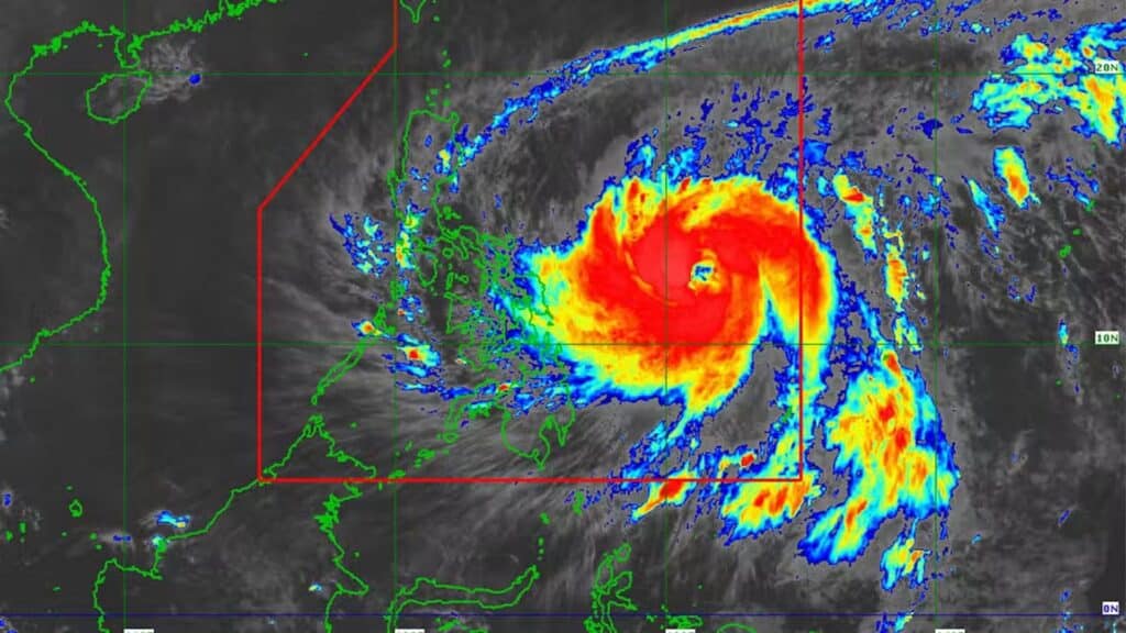
CEBU, Philippines — Every time a storm enters the Philipine Area of Responsibility (PAR), Filipinos brace for the impact of rain, floods, winds, and the long list of risks that come with any tropical cyclone.
Behind every weather bulletin lies a complicated atmospheric process that determines whether a disturbance like Tropical Depression “Wilma” will remain weak or intensify into something stronger.
As of 8 p.m. on Thursday, December 4, 2025, Tropical Depression Wilma has entered the Philippine Area of Responsibility (PAR), the Philippine Atmospheric, Geophysical and Astronomical Services Administration (PAGASA) reported.
READ: Wilma: Live updates
Intense to torrential rainfall is expected on Friday morning, December 5, as Wilma moves through the region.
Several local government units, including those in Cebu province, have suspended classes at all levels, as Pagasa has placed the province under Tropical Cyclone Wind Signal No. 1 and forecasts 50 to 100 millimeters (mm) of rain within 24 hours.
While Wilma is still in its weakest category, forecasters caution that its future strength depends entirely on the conditions surrounding it. Understanding how storms form, grow, and behave is key to comprehending the risks ahead.
Why storms start over the ocean
Everything begins with heat, and the ocean is one of the planet’s largest heat engines.
When the sun warms the sea surface, especially when temperatures exceed 26 degrees Celsius, water evaporates into the atmosphere. Warm, moist air rises, and as it climbs, it cools and condenses into clouds. This condensation releases latent heat, which acts like fuel.
This is why storms form over tropical oceans and why they usually strengthen before reaching land.
READ: EXPLAINER: What do color-coded rainfall warnings mean?
The birth of a cyclone
A tropical cyclone doesn’t form from just warm water. It needs a push, something to start the rotation.
This usually comes in the form of:
- A pre-existing low-pressure area
- A disturbance along the Intertropical Convergence Zone (ITCZ)
- A tropical wave
- Divergence in the upper atmosphere allows air below to rise
Once a disturbance gains enough rotation from the Coriolis effect (the Earth’s spin), a circular wind pattern begins to appear.
It is at this point that Pagasa can classify the system.
READ: EXPLAINER: How are storm signals and rainfall warnings different?
The stages of a storm
Pagasa uses five categories, and each one tells a story about what’s happening inside the system.
Tropical Depression (TD)
Winds: Up to 62 kph
This is the “starter” stage—where Wilma is now.
Winds are organized but still relatively weak. Despite the mild winds, the real danger lies in heavy rainfall, especially if the system moves slowly or draws moisture from the monsoon. Such rains can cause significant flooding, as some of the Philippines’ most severe flood events have shown, often triggered not by typhoons, but by tropical depressions.
Case Study: Tropical Depression Usman (Dec 28–29, 2018)
Usman never intensified beyond a tropical depression and had no international name, yet it became one of the deadliest weather systems of 2018. Prolonged rainfall triggered landslides and flooding across Bicol Region, Eastern Visayas, MIMAROPA, and CALABARZON, claiming over 150 lives and causing millions of pesos in damage. Rainfall totals exceeded 250 mm in 48 hours.
Moreover, to put this in perspective, Super Typhoon Odette, the 15th cyclone of the 2021 season, initially formed as a tropical depression, demonstrating how small weather systems can develop into major storms.
At this stage, forecasters constantly ask: Will it intensify? The answer depends on ocean heat, wind patterns, and upper-atmosphere conditions.
READ: EXPLAINER: The different categories of tropical cyclones
Tropical Storm (TS)
Winds: 62–88 kph
The storm tightens its circulation. Rainbands develop, winds strengthen, and satellite images begin to clearly show the system’s structure.
Residents feel stronger gusts, local governments step up flood and landslide preparations, and sea travel becomes riskier. If environmental conditions remain favorable, the storm may continue to intensify.
Case Study: Super Typhoon Odette – Tropical Storm Stage (Dec 2021)
Odette first appeared as a tropical storm with winds of 62–88 kph. Its tightening circulation produced visible rainbands on satellite images, prompting early flood and landslide alerts and the suspension of sea travel in Visayas and Mindanao. Thousands of residents were displaced preemptively as rainfall began accumulating.
Severe Tropical Storm (STS)
Winds: 87–117 kph
At this stage, the storm has enough structure to produce damaging winds, widespread rain, and significant flooding. Evacuation advisories often begin here, as light structures can be damaged and trees uprooted.
Case Study: Super Typhoon Odette – STS Stage (Dec 2021)
During this phase, Odette’s gusts uprooted trees and triggered initial evacuations across Siargao and Dinagat Islands. Widespread rain caused flooding, forcing communities to take early precautions before the storm escalated further.
Typhoon (TY)
Winds: 118–184 kph
The storm is now fully matured. The eyewall—a ring of towering thunderstorms around the eye—forms, producing the strongest winds. Typhoons can:
- Peel roofs
- Knock down power lines
- Trigger massive floods
- Spawn tornadoes
- Generate dangerous storm surges
Case Study: Super Typhoon Odette – Typhoon Stage (Dec 2021)
Odette’s eyewall battered eastern Mindanao, toppling power lines, flooding communities, and generating storm surges up to 10 meters. Even before reaching peak intensity, mature typhoons can paralyze infrastructure and amplify destruction.
READ: Signal No. 1 raised in 18 areas as Tropical Depression Wilma approaches
Super Typhoon (STY)
Winds: 185 kph and above
The highest and most destructive stage. Super typhoons draw massive amounts of heat from the ocean. Winds can flatten buildings, uproot trees, and devastate coastal areas through catastrophic storm surges.
Case Study: Super Typhoon Odette – Peak Intensity (Dec 2021)
Odette exceeded 260 kph, flattening buildings in Siargao, uprooting tree rows, and generating 7–10 meter storm surges that devastated coastal communities. It ranked among the Philippines’ worst disasters, leaving hundreds dead and causing over ₱20 billion in damage.
What makes storm so destructive
A tropical cyclone is not just a bundle of clouds. It is a complex engine with different hazards interacting at once:
Strong winds
Not only do cyclones bring sustained winds, but they also produce squalls—sudden bursts of violent gusts that last minutes and can tear off roofs unexpectedly.
Tornadoes
Storms can generate small tornadoes, especially over land, usually on the right-front quadrant of the storm’s path.
Heavy rainfall and flash floods
Water, not wind, causes most storm-related deaths in the Philippines.Even a weak tropical depression can deliver days of relentless rain.
Storm surge
This is the abnormal rise of seawater pushed by the storm’s winds.Surge can travel through bays, river mouths, and low-lying coasts—with devastating speed.
A typical storm surge can affect 160 kilometers of coastline, often just hours before landfall.
Why storms weaken on land
When a storm hits land, it loses access to its fuel source—the warm ocean.Land friction disrupts its circulation.
However, weakening winds do not mean a weakening threat.Heavy rainfall and flooding often intensify after landfall, especially in mountainous regions.
Why the Philippines always lies in the path
The country sits along the Northwest Pacific basin, the world’s most active cyclone region.
Warm seas, intersecting air masses, and the Philippines’ position near the ITCZ combine to make it one of the most storm-exposed nations on Earth.
This is why most Filipinos grow up familiar with the terms “signal,” “storm,” and “landfall”—but understanding the science helps explain why every bulletin matters./ with reports from PAGASA
Disclaimer: The comments uploaded on this site do not necessarily represent or reflect the views of management and owner of Cebudailynews. We reserve the right to exclude comments that we deem to be inconsistent with our editorial standards.
