



The Low Pressure Area being monitored in the past day has entered the Philippine Area of Responsibility (PAR) on Wednesday, November 3, 2025, and is named Wilma.
Bookmark this page to get track Wilma’s path, intensity changes, and key government advisories as they come in.
Stay tuned for live updates on Wilma to help you stay prepared and informed.
BALIK NA ANG BYAHE SA MGA BARKO SA SANTA FE
WILMA WEAKENS TO LPA
TRAVELERS CROWD PIER 1 IN CEBU CITY
TD Wilma causes flooding in Albay, Camarines Sur
Heavy rains brought by the shear line and Tropical Depression Wilma triggered flash floods in parts of Albay and Camarines Sur on Saturday, December 6, affecting thousands of residents and stranding hundreds of passengers.
According to the Department of Social Welfare and Development in Bicol Region (DSWD 5), 18 barangays were affected, impacting 3,809 families or 3,994 persons. Currently, 96 families or 275 individuals are staying in evacuation centers.
TD WILMA PADAYONG MIHULGA SA EASTERN SAMAR
TD Wilma now poses ‘low rainfall risk’ for Cebu — Pagasa
The threat of heavy rains in Cebu from Tropical Depression (TD) Wilma has eased, with local authorities saying the likelihood of significant flooding is now low.
Engineer Al Quiblat, chief of the Philippine Atmospheric, Geophysical and Astronomical Services Administration (Pagasa) Mactan, said on Saturday, December 6, that while Wilma remains active, its effects on Cebu are limited.
“Si Wilma wala lang gyud ta maapektuhan sa iyang cloud rain bands kay na-disorganized siya tungod sa Amihan,” Quibalt explained. “Ang iyang cloudiness […] pag-ulan, ni-shift didto sa Southern Luzon so nikalit usab ang behavior. Hinay man gyud siya nga bagyo, initially giexpect nato nga daghan pag-ulan diri sa ato pero mao to ni-shared man siya, wala na sa sentro ang pag-ulan.”
ARCHIVAL MIBISITA SA MGA NA STRANDED TUNGOD NI WILMA
BOHOL TO MINDANAO TRIPS RESUME
HINAY NGA PAG UWAN MASINATI SA SUGBO
Over 8,600 stranded passengers in ports due to TD Wilma
Over 8,600 passengers were stranded in different ports across the country on Saturday (December 6, 2025) due to Tropical Depression Wilma, according to the Philippine Coast Guard (PCG).
In its maritime advisory issued at 10 a.m., PCG said that there were 8,622 stranded passengers from 4 a.m. to 8 a.m. in 87 ports in Southern Tagalog, Northeastern Mindanao, Northern Mindanao, Southern Visayas, Bicol, Eastern Visayas, Central Visayas and Western Visayas.
Cebu still under Signal No 1: 211 evacuees take shelter amid TD Wilma
Steady rains and rising risks from Tropical Depression (TD) Wilma kept Cebu under Tropical Cyclone Wind Signal No. 1 on Saturday, December 6.
It also pushed more than 200 residents to evacuate as local authorities warned of continued bad weather throughout the weekend.
TD Wilma maintained its strength over the sea east of Eastern Visayas early Saturday, with maximum sustained winds of 45 km/h and gusts of up to 55 km/h, according to the 8 a.m. bulletin of the Philippine Atmospheric, Geophysical and Astronomical Services Administration (PAGASA).
TD Wilma: Another storm brings more woes to Visayas, Mindanao
A number of localities in Visayas and Mindanao experienced continuous rains ahead of Tropical Depression “Wilma’s” landfall on Friday night in Eastern Visayas, triggering evacuation, flooding, landslides, widespread class and work suspensions, and causing damage to roads and infrastructure.
A number of areas affected by TD Wilma have still to fully recover from three previous storms—Typhoon “Tino” (international name: Kalmaegi) on Nov. 4; and Supertyphoon “Uwan” (Fung-Wong) on Nov. 9; and Typhoon “Verbena” (Koto) on Nov. 24 and Nov. 25.
The visit of President Marcos in Bacolod City on Friday to launch the “Oplan Kontra Baha” was cancelled due to the incoming storm.
WATER LEVEL REMAINS NORMAL IN MANANGA RIVER
TD Wilma accelerates, to make landfall over E. Visayas Saturday
Tropical Depression Wilma slightly accelerated and is expected to make landfall over Eastern Visayas sometime Saturday, the weather bureau said.
As of 5 a.m., the Philippine Atmospheric, Geophysical and Astronomical Services Administration (PAGASA) said the center of TD Wilma was located 70 km. east of Borongan City, Eastern Samar, packing maximum sustained winds of 45 kph near the center and gustiness of up to 55 kph, and moving westward at 15 kph.
TD Wilma: Another storm brings more woes to Visayas, Mindanao
A number of areas affected by TD Wilma have still to fully recover from three previous storms—Typhoon “Tino” (international name: Kalmaegi) on Nov. 4; and Supertyphoon “Uwan” (Fung-Wong) on Nov. 9; and Typhoon “Verbena” (Koto) on Nov. 24 and Nov. 25.
The visit of President Marcos in Bacolod City on Friday to launch the “Oplan Kontra Baha” was cancelled due to the incoming storm.
TD Wilma slows as it nears PH landmass
Tropical Depression Wilma slightly decelerated as it continued to approach the country’s landmass on Friday afternoon, according to the Philippine Atmospheric, Geophysical and Astronomical Services Administration (Pagasa).
In its 2 p.m. tropical cyclone bulletin, Pagasa said Wilma was moving west-southwest at 10 kilometers per hour (kph).
The state weather bureau earlier said that TD Wilma slows as it moves west-southwest at 15 kph on Friday morning.
TD Wilma may make landfall in E. Visayas, Dinagat Islands tonight
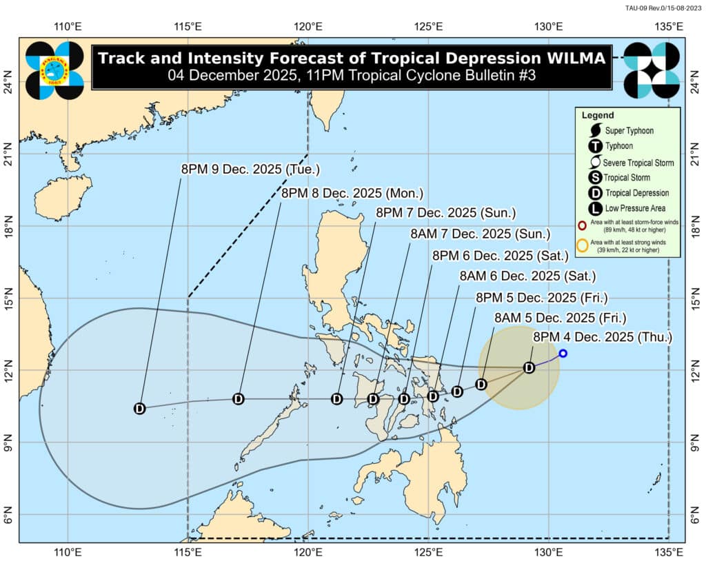
Tropical Depression Wilma may make its initial landfall or pass close to eastern Visayas or Dinagat Islands on Friday evening or Saturday morning, the Philippine Atmospheric, Geophysical and Astronomical Services Administration (Pagasa) said.
In its 11 a.m. bulletin, Pagasa said TD Wilma is forecast to move west-southwestward until Saturday.
“Afterwards, it will continue to traverse Visayas until Sunday (December 7). It will then emerge over the Sulu Sea and may pass over northern Palawan by Monday (December 8) morning,” Pagasa said.
Coast Guard halts all sea travel in Central Visayas due to TD Wilma
![[FILE PHOTO] Passengers flock to a seaport in Cebu City waiting for their turn to board the boats to take them back home in this April 2023 photo. Today, December 5, however, hundreds of passengers traveling by sea are stranded after the Philippine Coast Guard suspended sea travel due to Tropical Depression Wilma.| Photo by Cebu Port Authority [FILE PHOTO]](https://cebudailynews.inquirer.net/files/2025/12/IMG_7648-1024x768.jpeg)
Sea travel across Central Visayas has been suspended, stranding hundreds of passengers and halting all inbound and outbound voyages on Friday, December 5, as Tropical Depression Wilma continues to move closer to the Visayas.
The Philippine Coast Guard District Central Visayas (CGDCV) confirmed the suspension, citing rough sea conditions and strong winds triggered by Wilma and the prevailing Northeast Monsoon.
“Suspended pa tanan (All are still suspended) outbound and inbound byahe (travel) all stations of Coast Guard District Central Visayas,” the PCG said in a report released Friday afternoon.
CLICK LINK TO READ THIS STORY.
Pagasa: Signal No. 1 remains over parts of PH as TD Wilma holds strength

Tropical Depression (TD) Wilma maintained its strength on Friday, keeping Signal No. 1 raised over several areas, according to the Philippine Atmospheric, Geophysical and Astronomical Services Administration (PAGASA).
In its 11 a.m. bulletin, PAGASA said Wilma continues to pack maximum sustained winds of 45 kph and gusts of up to 55 kph.
The weather system was last spotted 235 km east of Borongan City, Eastern Samar, moving west-southwest at 15 kph.
CLICK THIS LINK TO READ FULL STORY.
LIST: Cancelled flights to and from Cebu due to TD Wilma

LAPU-LAPU CITY, Cebu — Several flights to and from Cebu have been cancelled due to the inclement weather brought by tropical depression Wilma.
The Mactan-Cebu International Airport announced the following affected flights as of 10:00 a.m. on Friday, December 5:
Departures:
- DG6791 Cebu to Ozamiz
- DG6803 Cebu to Ozamiz
- DG6641 Cebu to Pagadian
Arrivals:
- DG6792 Ozamiz to Cebu
- DG6804 Ozamiz to Cebu
- DG6642 Pagadian to Cebu
CLICK THIS LINK TO READ FULL STORY.
TUNGOD NI WILMA NAALIHAN OG YUTA ANG DAN SA ALEGRIA
EXPLAINER: How storms form and strengthen
![Low-lying coastal areas under storm surge alert as Uwan intensifies [file photo]](https://cebudailynews.inquirer.net/files/2025/12/Low-lying-coastal-areas-under-storm-surge-alert-as-Uwan-intensifies--1024x576.jpg)
Every time a storm enters the Philipine Area of Responsibility (PAR), Filipinos brace for the impact of rain, floods, winds, and the long list of risks that come with any tropical cyclone.
Behind every weather bulletin lies a complicated atmospheric process that determines whether a disturbance like Tropical Depression “Wilma” will remain weak or intensify into something stronger.
As of 8 p.m. on Thursday, December 4, 2025, Tropical Depression Wilma has entered the Philippine Area of Responsibility (PAR), the Philippine Atmospheric, Geophysical and Astronomical Services Administration (PAGASA) reported.
Intense to torrential rainfall is expected on Friday morning, December 5, as Wilma moves through the region.
Several local government units, including those in Cebu province, have suspended classes at all levels, as Pagasa has placed the province under Tropical Cyclone Wind Signal No. 1 and forecasts 50 to 100 millimeters (mm) of rain within 24 hours.
While Wilma is still in its weakest category, forecasters caution that its future strength depends entirely on the conditions surrounding it. Understanding how storms form, grow, and behave is key to comprehending the risks ahead.
CLICK THIS LINK TO READ FULL STORY.
WILMA AND COAST GUARD IN CV
Rainfall warning over Cebu
Wilma to bring heavy rain in Cebu this weekend — Pagasa
Cebu may experience moderate to occasionally heavy rains until Sunday, December 7, due to tropical depression Wilma, the state weather bureau reported.
In its 5:00 a.m. forecast, the Philippine Atmospheric, Geophysical and Astronomical Services Administration (Pagasa) said Cebu could expect 50 to 100 millimeters (mm) of rainfall on Friday.
Heavier rains are expected on Saturday, with projected rainfall reaching 100 to 200 mm as the weather system moves closer to the Visayas.
Rains are likely to persist through Sunday, though conditions may gradually improve as Wilma weakens while crossing the region.
CLICK THIS LINK TO READ FULL STORY.
TD Wilma: Signal No. 1 up in parts of Cebu
Portions of northern and central Cebu were placed under Tropical Cyclone Wind Signal No. 1 on Thursday evening due to the effects of Tropical Depression Wilma.
This is according to the December 4 (Thursday) 11 p.m. weather advisory of the Philippine Atmospheric, Geophysical and Astronomical Services Administration (Pagasa).
Pagasa said Tropical Depression Wilma was maintaining its strength and continued to move west-southwestward over the Philippine Sea.
Its center was estimated to be 480 km east of Catarman, Northern Samar, or 390 km east of Borongan City, Eastern Samar.
Several areas have been placed under Signal No. 1, including portions of northern and central Cebu.
These are Daanbantayan, Medellin, Bogo City, San Remigio, Tabogon, Borbon, Tabuelan, Tuburan, Sogod, Catmon, Asturias, Carmen, Danao City, Balamban, Compostela, Liloan, Consolacion, Cebu City, Mandaue City, Cordova, Lapu-Lapu City, Toledo City, Pinamungahan, San Fernando, Naga City, Minglanilla, Talisay City, Aloguinsan, Carcar City, Sibonga, Barili, and the islands of Bantayan and Camotes.
CLICK THIS LINK TO READ FULL STORY.
CEBU CITY SUSPENDS FACE-TO-FACE CLASSES IN ALL LEVELS
CEBU UNDER SIGNAL NO. 1 DUE TO TD WILMA
#WILMAPH: LAPU-LAPU CITY SUSPENDS CLASSES
NO CLASSES FOR THE NEXT TWO DAYS IN MADRIDEJOS DUE TO WILMA
CANCELED TRIPS IN CEBU DUE TO WILMA
CARCAR SUSPENDS FACE-TO-FACE CLASSES DUE TO TD WILMA
Cebu City ready for evacuations as TD Wilma threatens heavy rain, floods
CEBU CITY, Philippines — Local officials here are urging residents in low-lying, flood-prone areas to prepare for possible evacuations as Tropical Depression Wilma approaches, bringing strong winds and heavy rainfall that could trigger flooding across the city.
Engineer Al Quiblat, chief of the Philippine Atmospheric, Geophysical and Astronomical Services Administration (Pagasa) Mactan, said on Thursday that Cebu is forecast to receive between 50 to 100 millimeters of rain from Thursday evening through Friday.
He said this is equivalent to 250,000 to 500,000 drums of water per square kilometer.
CLICK HERE TO READ FULL STORY.
COAST GUARD IN CENTRAL CEBU SUSPENDS MOVEMENTS OF VESSELS DUE TO WILMA
DANAO-CONSUELO FERRY TRIPS CANCELLED DUE TO TD WILMA
CEBU-ORMOC FERRY TRIPS CANCELLED DUE TO TD WILMA
LIST: Class suspensions in Cebu due to #Wilma
CEBU CITY, Philippines – Several localities in Cebu on Thursday, December 4, have announced class suspensions as threats of bad weather loom due to Tropical Depression Wilma.
As of Thursday, Talisay City and the neighboring town of Minglanilla announced their decision to cancel in-person classes for all levels on Friday, December 5.
CLICK HERE TO READ FULL STORY.
WAY KLASE SA MINGLANILLA TUNGOD NI WILMA
50-100 MM OF RAINFALL ANTICIPATED IN CEBU
TD Wilma: Signal No. 1 up in parts of eastern Visayas, Mindanao

Tropical Cyclone Wind Signal Number 1 was raised in the eastern portions of Visayas and in some areas in Mindanao on Thursday morning, and this is due to the effects of Tropical Depression Wilma.
This is according to the Philippine Atmospheric, Geophysical and Astronomical Service Administration (Pagasa) on Thursday.
The places under Signal Number 1 will experience wind speeds of 39 to 61 kilometers per hour (kph) for at least 36 hours, which may cause light damage to structures, Pagasa said.
In Visayas, Northern Samar, Eastern Samar, Samar, Biliran, Leyte and Southern Leyte are forecast to be affected by the bad weather.
Signal no. 1 has also been hoisted in Surigao del Norte in Mindanao, including Siargao and Bucas Grande Islands and Dinagat Islands.
WILMA NISUD NA SA NASUD
Tropical Depression Wilma to bring rains in Cebu – Pagasa
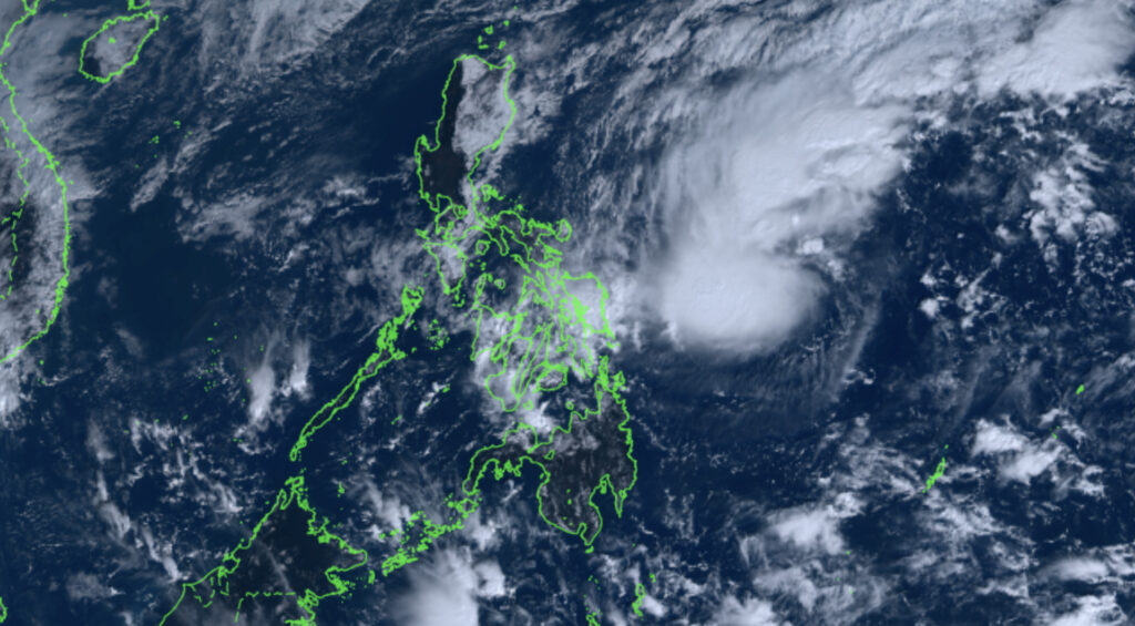
The low-pressure area (LPA) inside the Philippine Area of Responsibility (PAR) has developed into a tropical depression that will likely bring rains in Cebu over the weekend.
The Philippine Atmospheric Geophysical and Astronomical Services Administration (Pagasa) on Thursday, December 4, announced that the LPA had turned into a tropical depression, assigning it the name Wilma.
Wilma was last spotted approaching Eastern Visayas on Thursday morning.
Due to the tropical depression’s presence, Central Visayas will experience moderate to occasional heavy rains that can last until Sunday, December 7.
Pagasa: LPA outside PAR may develop into tropical depression in 24 hours
A low-pressure area brewing over the Pacific is showing stronger signs of development, with state meteorologists warning that it may strengthen into a tropical depression as early as today.
The Philippine Atmospheric, Geophysical and Astronomical Services Administration (Pagasa) said on Wednesday, December 3, that Low Pressure Area (LPA) 12a, currently located outside the Philippine Area of Responsibility (PAR), now has a “high” chance of developing into a tropical depression within the next 24 hours.
As of 8 a.m., Pagasa continues to monitor LPA 12a alongside another system—LPA 11b (formerly “Verbena”)—also positioned outside PAR.
In a previous briefing, Pagasa weather specialist Chenel Dominguez said the LPA east of the country has the potential to escalate even further.
“There is a high chance that this will become a full-blown typhoon within the next 24 to 48 hours, and once it enters our PAR as a typhoon, we will name it Wilma,” Dominguez said.
Pagasa: LPA outside PAR has ‘high’ chance of becoming tropical depression
A low pressure area (LPA) has formed on Monday afternoon, December 1, and is being monitored outside the Philippine Area of Responsibility (PAR) by the state weather bureau.
According to the Philippine Atmospheric, Geophysical and Astronomical Services Administration (Pagasa), the LPA has a high potential of developing into a tropical depression within the next 24 to 48 hours.
“We can see in our forecast track that it may possibly make landfall in Eastern Visayas or Caraga. But for now, there is still high uncertainty on its possible track,” said weather specialist Chenel Dominguez.
Subscribe to our regional newsletter
Disclaimer: The comments uploaded on this site do not necessarily represent or reflect the views of management and owner of Cebudailynews. We reserve the right to exclude comments that we deem to be inconsistent with our editorial standards.
