More areas under Signal Nos. 1 and 2 as Ulysses turns into severe tropical storm
MANILA, Philippines — Ulysses intensified into a severe tropical storm on Tuesday night, the Philippine Atmospheric, Geophysical and Astronomical Services Administration (Pagasa) said.
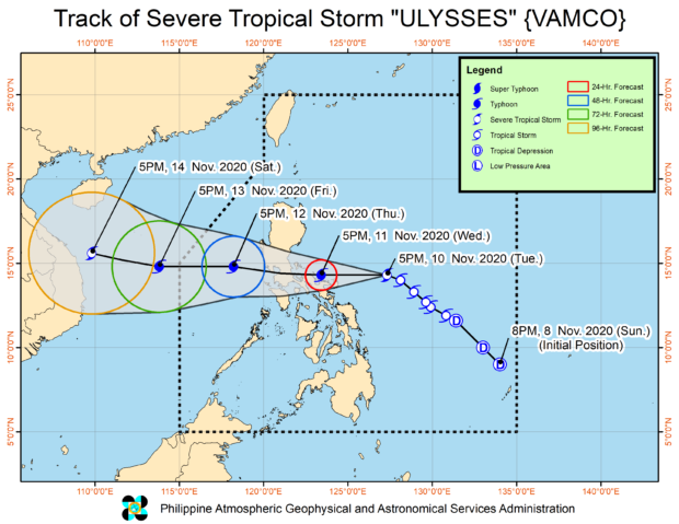
According to the latest severe weather bulletin, Ulysses now packs maximum sustained winds of 95 kilometers per hour (kph) near the center and gustiness of up to 115 kph. It has moved closer to land, at 425 kilometers east of Daet, Camarines Norte.
It is still moving northwestward, at a slightly accelerated speed of 30 kph.
In addition, Pagasa has placed more areas under Tropical Cyclone Wind Signal No. 2, which means high-risk structures and those made of light materials may sustain light to moderate damage:
- Central and southern portions of Quezon (Atimonan, Pagbilao, Padre Burgos, Agdangan, Unisan, Plaridel, Gumaca, Pitogo, Macalelon, General Luna, Catanauan, Mulanay, San Francisco, San Andres, San Narciso, Buenavista, Lopez, Guinayangan, Calauag, Tagkawayan, Quezon, Alabat, Perez) including Polillo Island
- the whole Bicol Region except Masbate (Catanduanes, Camarines Norte, Camarines Sur, Albay, Sorsogon, Burias and Ticao Islands)
- Marinduque
More areas were also added to the list of cities, municipalities, and provinces under Signal No. 1:
- Mountain Province
- Ifugao
- Benguet
- La Union
- Pangasinan
- Central and southern portions of Isabela (Quezon, Delfin Albano, Tumauini, Divilacan, Mallig, Quirino, Ilagan, Palanan, San Mariano, Benito Soliven, Naguilian, Gamu, Burgos, Roxas, San Manuel, Aurora, Luna, Reina Mercedes, Cauayan City, Cabatuan, San Mateo, Alicia, Angadanan, San Guillermo, Dinapigue, Echague, San Isidro, Ramon, Santiago City, Cordon, Jones, San Agustin)
- Quirino
- Nueva Vizcaya
- Central Luzon (Aurora, Nueva Ecija, Tarlac, Pampanga, Bulacan, Zambales, Bataan)
- Metro Manila
- the rest of Quezon and Calabarzon (Rizal, Laguna, Cavite, Batangas)
- the rest of Masbate
- Romblon
- Oriental Mindoro
- Occidental Mindoro including Lubang Island
- Northern Samar
- Northern portion of Samar (Santo Nino, Almagro, Tagapul-An, Tarangnan, Calbayog City, Santa Margarita, Gandara, Pagsanghan, San Jorge, San Jose de Buan, Matuguinao)
- Northern portion of Eastern Samar (Maslog, Dolores, Oras, San Policarpo, Arteche, Jipapad)
The latest forecast on the track of Ulysses indicates that it will hit land between Camarines Norte and the Quezon province area early Thursday morning, likely gliding near Catanduanes and other areas in Camarines Norte prior to landfall, Pagasa said.
It also said that due to favorable conditions, Ulysses may intensify as a typhoon by Wednesday morning, hence declaring Signal No. 3 in some areas remains possible.
Likewise, by Wednesday morning, Pagasa said rainbands of Ulysses are forecast to bring moderate to heavy rains in the Bicol Region, portions of Quezon, and Samar provinces.
Then by Wednesday afternoon, Ulysses is seen to be just 55 kilometers northeast of Daet, Camarines Norte, and cross Southern Luzon en route to the southern part of Metro Manila before it exits the landmass around Thursday afternoon, it added.
Pagasa said it expects light to moderate with at times heavy rains over Aurora, Quezon, Bicol Region, Eastern and Central Visayas, Caraga, Northern Mindanao, Zamboanga Peninsula, and Bangsamoro due to Ulysses.
Disclaimer: The comments uploaded on this site do not necessarily represent or reflect the views of management and owner of Cebudailynews. We reserve the right to exclude comments that we deem to be inconsistent with our editorial standards.