PH’s first weather disturbance in 2021 may affect Cebu
CEBU CITY, Philippines – The first major weather disturbance to enter the country this 2021 could pass and affect Cebu, the state weather bureau said.
The Philippine Atmospheric Geophysical and Astronomic Services Administration in Mactan (Pagasa-Mactan) confirmed that they are projecting Tropical Depression Auring’s effects to reach the Visayas, particularly Cebu.
“Based on our current forecast, Auring will make landfall within the Caraga and Davao regions and may pass through southern Visayas. Its outer rain bands could affect Cebu,” said Rech Sunbise, weather specialist of Pagasa-Mactan, in Cebuano.
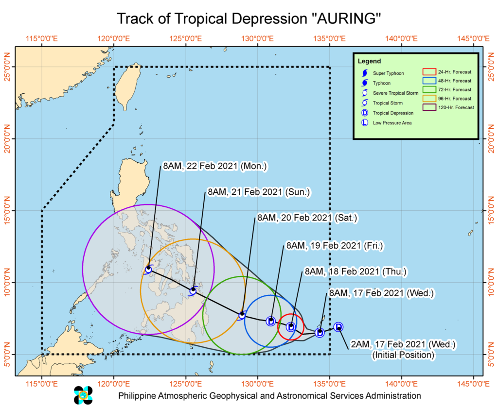
Auring entered the Philippine Area of Responsibility (PAR) at 8 a.m. on Wednesday, February 17.
Pagasa, in its 11 a.m. severe weather bulletin on Wednesday, located the center of Auring 900 kilometers east of Hinatuan town in Surigao del Sur.
Auring packs winds with speeds of 45 kilometers per hour (kph) and gustiness reaching up to 55 kph. It is moving west-southwest at a speed of 20 kph.
It is expected to make its first landfall within the regions of Caraga and Davao between Saturday evening (February 20) and Sunday morning (February 21).
“No locality is currently under Tropical Cyclone Wind Signal (TCWS) No. 1,” Pagasa noted.
“However, in anticipation of the arrival of the strong breeze to near-gale conditions due to Auring, TCWS No. 1 may be raised over several provinces of Caraga and Davao Region as early as Friday, which may result in the disruption of maritime activities,” they added.
Pagasa also urged local governments in areas to be affected by the tropical depression to start preparing disaster-mitigating measures.
“Localities in Visayas, Bicol Region, MIMAROPA, Caraga, Northern Mindanao, Davao Region, Cotabato, and Lanao del Sur, especially those situated in areas identified in hazard maps to be highly or very highly susceptible to these hazards, are advised to take appropriate preparatory measures due to increased likelihood of heavy rains and gusty conditions associated with the potential passage of a tropical cyclone during the weekend through Monday,” Pagasa said.
But even if Auring’s wrath is yet to be felt in Central Visayas, the state weather bureau said cloudy skies with occasional heavy rains will prevail here due to the presence of another weather system – the tail-end of a frontal system.
“Isolated flooding and rain-induced landslides may occur due to heavy rainfall or prolonged periods of rainfall, especially in areas identified in hazard maps to be highly or very highly susceptible to these hazards,” added Pagasa.
The tail-end of a frontal system is the boundary between the cold wind of the amihan (northeast monsoon) and the easterlies or warm wind from the Pacific Ocean. /rcg
Disclaimer: The comments uploaded on this site do not necessarily represent or reflect the views of management and owner of Cebudailynews. We reserve the right to exclude comments that we deem to be inconsistent with our editorial standards.