Pagasa: Falcon intensifies, may develop into typhoon by Sunday

Pagasa: Falcon intensifies, may develop into typhoon by Sunday
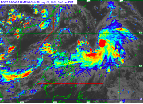
MANILA, Philippines — Tropical Storm Falcon (international name: Khanun) has intensified while accelerating northwest over the Philippine Sea and may develop into a typhoon by Sunday, the state weather bureau said Saturday.
In its Saturday afternoon bulletin, the Philippine Atmospheric, Geophysical and Astronomical Services Administration (Pagasa) said the eye of Falcon was last plotted some 1,205 kilometers east of Central Luzon, and increased its maximum sustained winds from 65 kilometers per hour (kph) to 75 kph, gustiness from 80 kph to 90 kph while moving north at 20 kph from 10 kph hours earlier.
Typhoon alert!
“Falcon is forecast to steadily intensify within the next three days. It is forecast to become a typhoon Sunday (July 30) afternoon or evening and reach its peak intensity on late Monday (July 31) or early Tuesday (August 1),” Pagasa said.
Pagasa’s latest forecast track suggests that the weather disturbance may exit the Philippine area of responsibility between Monday evening and Tuesday morning.
Rain forecast
The raising of tropical cyclone wind signals is less likely, but state meteorologists warned that Falcon is expected to enhance the southwest monsoon, or “habagat and trigger occasional rain and windy conditions over the western portions of Luzon and the Visayas.
“This tropical cyclone will remain over the Philippine Sea and far from the Philippine landmass throughout the forecast period,” Pagasa added.
RELATED STORIES:
Khanun enters PAR, now called tropical storm Falcon — Pagasa
Falcon decelerates, remains far from PH landmass — Pagasa
gsg
Disclaimer: The comments uploaded on this site do not necessarily represent or reflect the views of management and owner of Cebudailynews. We reserve the right to exclude comments that we deem to be inconsistent with our editorial standards.
