Storm signals up in Camotes, other VisMin areas due to tropical depression ‘Kabayan’
CEBU CITY, Philippines — Several parts of Visayas and Mindanao are now placed under Tropical Cyclone Warning Signal No. 1 including Camotes Islands in Cebu due to Tropical Depression “Kabayan.”
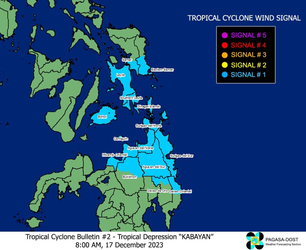
The tropical depression continued to move eastward over the sea east of Mindanao on Sunday, December 17, according to the Tropical Cyclone Bulletin issued by the Philippine Atmospheric, Geophysical and Astronomical Services Administration (Pagasa) at 8 a.m.
Kabayan was last spotted at 460 kilometers east of Davao City with maximum sustained winds 55 kilometers per hour.
Areas under Signal No. 1
In Visayas, Pagasa has placed the Camotes group of islands in Cebu under Tropical Cyclone Wind Signal (TCWS) No. 1 along with southern portions of Samar (Basey, Santa Rita, Marabut, Talalora, Villareal, Pinabacdao), southern portion of Eastern Samar (Maydolong, City of Borongan, Quinapondan, Guiuan, Lawaan, Balangiga, Llorente, Giporlos, Salcedo, Balangkayan, General Macarthur, Hernani, Mercedes), Leyte, Southern Leyte, and Bohol.
Meanwhile in Mindanao, the following areas have been placed under TCWS No. 1: Dinagat Islands, Surigao del Norte, Surigao del Sur, Agusan del Sur, northern portion of Davao Oriental (Cateel, Boston, Baganga), northern portion of Davao de Oro (Monkayo, Laak), Misamis Oriental, Camiguin, northern portion of Bukidnon (Impasug-Ong, Malitbog, Manolo Fortich, Sumilao, Libona, Baungon, Cabanglasa, City of Malaybalay).
Pagasa said that strong winds may be experienced in these areas and minimal to minor impacts from strong winds are possible within any of the areas under TCWS No. 1.
Rainfall is forecast in those areas while for tomorrow, rainfall is expected in the southern portions of Eastern Samar and Samar, the eastern and southern portions of Leyte, Bohol, Cebu, Negros Oriental, Siquijor, Camiguin, Misamis Oriental, the northern portion of Bukidnon, Agusan del Sur, Agusan del Norte, Surigao del Sur, Surigao del Norte, Dinagat Islands, and Southern Leyte.
The state weather bureau cautioned the public that flooding and rain-induced landslides are likely to occur, especially in mountainous or elevated areas.
Moreover, the shear line may also bring heavy rainfall over the eastern portion of southern Luzon on Sunday and over the eastern portion of Luzon tomorrow, Monday, December 18.
Kabayan is forecast to move the west northwestward path across the Philippine archipelago over the next two days and it is likely to maintain its strength until its initial and landfall over Mindanao.
It is reported to landfall along the coast of Surigao del Sur or Davao Oriental on Sunday night or Monday morning.
Pagasa said that they are also not ruling out the possibility of Kabayan reaching the Tropical Storm category.
The public is advised to take precautionary measures, especially those who live in hazardous areas. /clorenciana
READ MORE: LPA east of Surigao del Sur now Tropical Depression Kabayan – Pagasa
Tropical depression may become typhoon by Saturday, to affect VisMin area
Disclaimer: The comments uploaded on this site do not necessarily represent or reflect the views of management and owner of Cebudailynews. We reserve the right to exclude comments that we deem to be inconsistent with our editorial standards.