
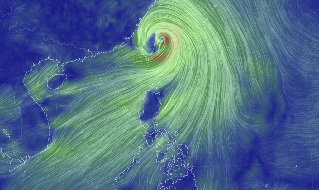
Super Typhoon Carina 📷: Earth NullSchool
(UPDATED, Wednesday, July 24, 5:11 p.m.) Here are the latest updates on #CarinaPH, which has developed into a super typhoon.
Please bookmark this page to get the latest updates on the two tropical depressions in the country.


A visitor (bottom R) takes photographs in front of the Chiang Kai-shek Memorial Hall in heavy rain from weather patterns caused by Typhoon Gaemi in Taipei on July 24, 2024. Taiwan closed schools, suspended the stock market, and declared a typhoon holiday on July 24 as Gaemi barrelled towards the island, bringing torrential rains and whipping winds to its northeast. (Photo by Sam Yeh / AFP)
Taiwan shuts down as deadly Typhoon Gaemi makes landfall
Typhoon Gaemi made landfall on Taiwan’s eastern coast in the early hours of Thursday, after unleashing torrential rainfall and whipping winds across the island that left two people dead.
On its path to Taiwan, Gaemi had also exacerbated seasonal rains in nearby Philippines, triggering flooding and landslides that killed six.
The superstorm hit Taiwan’s eastern Yilan County at around 12:00 am local time Thursday (1600 GMT Wednesday), said the Central Weather Administration.
Read full story here.

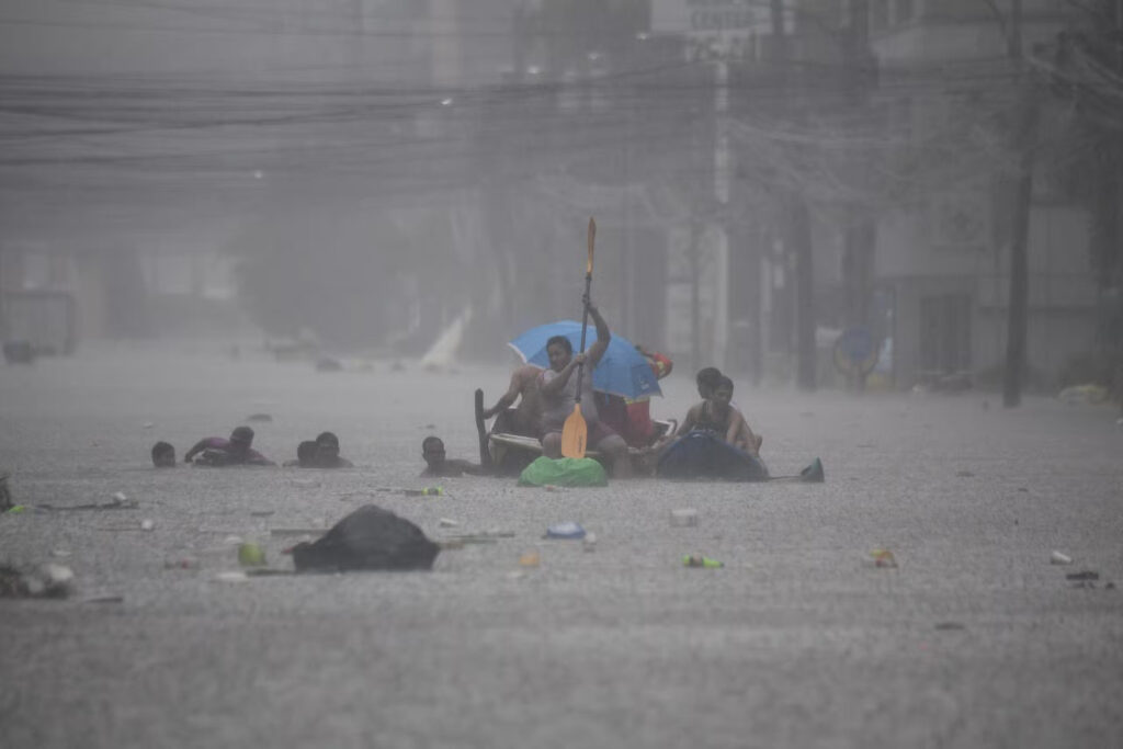
Rescuers paddle their boats along a flooded street in Manila on July 24, 2024 amid heavy rains brought by Typhoon Gaemi. Relentless rain drenched the northern Philippines on July 24, triggering flooding in Manila and landslides in mountainous regions as Typhoon Gaemi intensified the seasonal monsoon. (Photo by Ted ALJIBE / AFP)
Typhoon Carina: Metro Manila under state of calamity
A resolution declaring the capital region under a state of calamity has been approved by the Metro Manila Council (MMC).
This is due to the onslaught of Typhoon Carina and the southwest monsoon.
Putting the capital region under a state of calamity would enable the release of calamity funds for 16 cities and one municipality in Metro Manila and allows the implementation of price control in the region.
Read full story here.

Carina now a Super Typhoon
– Carina (international name Gaemi) on Wednesday, July 24, has intensified into a super typhoon hours after bringing intense rains and severe floodings in Metro Manila.
At 4:55 p.m., the state weather bureau announced that Carina developed into a super typhoon as it made its way to northern Taiwan where it is expected to make another landfall.
Read full story here

Carina blows past Philippines turning streets into rivers
Relentless rain drenched the northern Philippines on Wednesday, triggering floods in Manila and landslides in mountainous regions as Typhoon Gaemi locally called Typhoon Carina intensified the seasonal monsoon.
In the densely populated capital, rescuers were deployed across the city to help evacuate people from low-lying homes after downpours turned streets into rivers, trapping vehicles.
Read full story here.

Taiwan prepares for typhoon that left 12 dead in Philippines
TAIPEI, Taiwan — Taiwan shuttered offices, schools and tourist sites across the island Wednesday ahead of a powerful typhoon that already worsened seasonal rains in the Philippines, killed at least 12 people and displaced 600,000.
Typhoon Gaemi’s outer skirt was bringing heavy rain to much of Taiwan, where a direct landfall was expected Wednesday evening in the northern county of Ylan. Fishing boats were recalled to port amid turbulent seas, while air travelers were rushing to board overseas flights before the storm arrives, amid numerous cancellations.
Read full story here.
Signal No. 2 up in Batanes as typhoon Carina intensifies
Tropical Cyclone Wind Signal (TCWS) No. 2 was raised over Batanes as Typhoon Carina (international name: Gaemi) further intensified as it headed towards Taiwan.
This is according to the state weather bureau this early Wednesday morning.
According to the Philippine Atmospheric, Geophysical and Astronomical Services Administration (Pagasa), that Signal No. 2 has been raised over Batanes where winds of from 62 to 88 kph are expected in the next 24 hours.
Read full story here.
Butchoy, Carina leaves 8 dead, 1 missing – NDRMMC
Tropical cyclones Butchoy and Carina have reportedly left eight persons dead, said the National Disaster Risk Reduction and Management Council (NDRRMC) said on Tuesday.
Seven deaths were already validated while one of those reported deaths was still for validation, said the NDRRMC.
Read full story here
Typhoon Carina slightly intensifies, Signal No. 2 up in Batanes
Tropical Cyclone Wind Signal No. 2 was raised over parts of Batanes as Typhoon Carina (International name: Gaemi) slightly intensified, the Philippine Atmospheric, Geophysical and Astronomical Services Administration (Pagasa) said on Tuesday.
In its 11:00 a.m. bulletin, Pagasa said Itbayat, Basco, Mahatao, Uyugan, and Ivana in Batanes are under Signal No. 2.
Read full story here
Signal no. 1 may be raised in Extreme Northern Luzon on Monday
The state weather bureau is not ruling out the possibility of raising storm signal no. 1 over some areas in Extreme Northern Luzon within the day or on Monday (July 22) when President Ferdinand Marcos Jr. will deliver his third State of the Nation Address (Sona).
This possibility is due to the effects of severe tropical storm Carina (international name: Gaemi).
Read full story here.
Pagasa: Tropical Depression Butchoy exits PAR
Tropical Depression Butchoy has now left the Philippine area of responsibility (PAR), the Philippine Atmospheric, Geophysical and Astronomical Services Administration (Pagasa) said.
Based on Pagasa’s 11 a.m. advisory, Butchoy was located 565 kilometers (km) west of Iba, Zambales, as of 10 a.m. on Saturday, July 20.
READ full story here.
#TDButchoy maintains strength as it exits PAR this morning
Based on its 5am bulletin, Pagasa said the center of Tropical Depression Butchoy was estimated based on all available data at 545 km West of Subic Bay, Zambales.
It has maximum sustained winds of 55 km/h near the center, gustiness of up to 70 km/h, and moving west northwestward at 20 km/h. #TDButchoy still packs strong winds that extend outwards up to 150 km from the center.
READ: Full story here
LPA develops into tropical depressions
In a tropical cyclone update, the Philippine Atmospheric, Geophysical and Astronomical Services Administration (Pagasa), in its Facebook page, said that at 8 p.m. on Friday, July 19, the Low Pressure Areas (LPA) west of Batangas and east of Eastern Visayas developed into Tropical Depressions #ButchoyPH and #CarinaPH, respectively.

TD Butchoy
Pagasa said in a bulletin that Butchoy is unlikely to directly affect the country within the next three days. However, the Southwest Monsoon that it enhances may still bring moderate to heavy rains over the western portion of Luzon over the next three days.
The center of the eye of Butchoy was estimated based on all available data 535 km West of Tanauan City, Batangas.
Butchoy is forecast to move generally west northwestward until Saturday before turning more north northwestward beginning on Sunday, July 21.
On the track forecast, this tropical depression may exit the Philippine Area of Responsibility (PAR) within the next 12 hours.
Furthermore, a landfall scenario over Hainan, China is likely by late Sunday or early Monday, July 22.
TD Carina
Meanwhile, the Southwest Monsoon currently enhanced by TD Butchoy will also be enhanced by TD Carina beginning on Sunday, July 21, resulting in moderate to heavy rains over the western portion of Luzon over the next three days, Pagasa said.
The center of the eye was estimated based on all available data 780 km East of Virac, Catanduanes.
Carina is forecast to move generally northwestward until Sunday. It is then forecast to decelerate while turning north northwestward on Monday before accelerating northward over the Philippine Sea towards the Ryukyu archipelago from Tuesday onwards.
In general, Pagasa said, Carina will generally have a mainly offshore path over the next five days and remain far from the Philippine landmass.
Pagasa update on Butchoy, Carina

TD BUTCHOY TO EXIT PAR
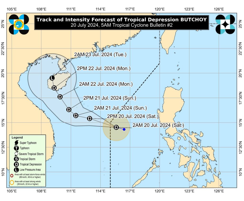

Tropical Depression #ButchoyPH maintains its strength and is about to exit the Philippine Area nof Responsibility (PAR) based on a Pagasa bulletin issued at 6 a.m. on Saturday, July 20.
The center of TD Butchoy was estimated, based on all available data, at 545 kilometers West of Subic Bay. It packs maximum sustained winds of 55 km/h near the center, gustiness of up to 70 km/h, and central pressure of 1002 hPa. Its present movement
is west northwestward at 20 km/h.
Butchoy is forecast to move generally west northwestward today before turning more north northwestward beginning tomorrow (21 July). On the track forecast, this tropical depression will exit the PAR region this morning, Pagasa said.
