Tropical Storm Quinta intensifies as it nears Bicol region
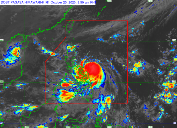
MANILA, Philippines — Tropical Storm Quinta (international name: Molave) has slightly intensified while inching closer to Catanduanes, Albay and Sorsogon in the Bicol region where it is expected to make landfall, the state weather bureau said Sunday.
In its 8 a.m. weather bulletin, the Philippine Atmospheric, Geophysical and Astronomical Services Administration (Pagasa) said that “Quinta” was last spotted at 265 kilometers east of Virac, Catanduanes.
“Quinta” packs maximum sustained winds of 75 kilometers per hour (kph) near the center and gustiness of up to 90 kph. while moving west at 25 kph.
Pagasa said “Quinta” is expected to make landfall over the Catanduanes-Albay-Sorsogon area by Sunday afternoon or evening.
Tropical Cyclone Wind Signal (TCWS) No. 2 is hoisted over the following areas:
- Catanduanes
- Camarines Norte
- Camarines Sur
- Albay
- Sorsogon
- the northern portion of Masbate (Milagros, Masbate City, Mobo, Baleno, Aroroy, Mandaon, Uson) including Burias and Ticao Islands
- the central and southern portions of Quezon (Mauban, Sampaloc, Lucban, Dolores, Candelaria, Tiaong, San Antonio, Sariaya, Tayabas City, Lucena City, Pagbilao, Atimonan, Perez, Alabat, Calauag, Quezon, Tagkawayan, Guinayangan, Lopez, Pitogo, Plaridel, Gumaca, Unisan, Agdangan, Padre Burgos, Macalelon, Catanauan, General Luna, Buenavista, San Narciso, Mulanay, San Andres, San Francisco)
- the eastern portion of Batangas (Padre Garcia, Rosario, Ibaan, Batangas City, Lobo, Taysan, San Juan)
- Marinduque
- Romblon
- Oriental Mindoro
- Northern Samar
Meanwhile, TCWS No. 1 is raised over:
- The rest of Masbate
- the rest of Quezon
- Laguna
- Rizal
- the rest of Batangas
- Cavite
- Metro Manila
- Bulacan
- Pampanga
- Bataan
- the southern portion of Zambales (San Marcelino, San Felipe, San Narciso, Castillejos, Subic, San Antonio, Olongapo City, Botolan, Cabangan)
- Occidental Mindoro
- Calamian Islands
- the northern portion of Samar (Calbayog City, Matuguinao, Tagapul-An, Santo Nino, Almagro, Santa Margarita, Gandara, San Jose de Buan, Pagsanghan, Tarangnan, San Jorge, Catbalogan City, Jiabong, Motiong, Paranas)
- the northern portion of Eastern Samar (Maslog, Jipapad, Arteche, San Policarpo, Oras, Dolores, Can-Avid, Taft)
- the northern portion of Capiz (Sapi-An, Ivisan, Roxas City, Panay)
- Aklan
- the northern portion of Antique (Caluya, Libertad, Pandan, Sebaste, Culasi)
Moderate to heavy to at times intense rains are expected over the Bicol region, Cavite, Laguna, Batangas, Rizal, Quezon, Aurora, Occidental Mindoro, Oriental Mindoro, Romblon, Marinduque, Calamian Islands, Northern Samar, Eastern Samar, Samar, Biliran, Aklan and Antique.
Meanwhile, the tail-end of a frontal system will likewise bring moderate to heavy with at times intense rains over the northern portions of mainland Cagayan including Babuyan Islands, Apayao, and Ilocos Norte.
These two weather systems will also bring light to moderate to at times heavy rains over Metro Manila, Cordillera Administrative Region, Zamboanga Peninsula, Bangsamoro region, Northern Mindanao, Caraga, and the rest of Visayas, Cagayan Valley, Central Luzon, and Mimaropa (Mindoro, Marinduque, Romblon, Palawan), Pagasa said.
Quinta is expected to exit the Philippine area of responsibility on Tuesday afternoon.
Disclaimer: The comments uploaded on this site do not necessarily represent or reflect the views of management and owner of Cebudailynews. We reserve the right to exclude comments that we deem to be inconsistent with our editorial standards.