Six areas in Luzon under Signal No. 2 due to Tropical Storm Maring
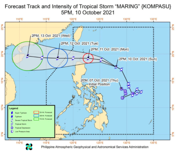
MANILA, Philippines — Six areas in Luzon are now under Tropical Cyclone Wind Signal (TCWS) No. 2 due to Tropical Storm Maring, said the Philippine Atmospheric, Geophysical, and Astronomical Services Administration (Pagasa).
Based on Pagasa’s latest storm bulletin at 5:00 p.m., damaging gale-force to storm-force winds are expected to prevail in the next 24 hours over areas under Signal No. 2.
Meanwhile, strong winds are expected within the next 36 hours in the 18 areas under Signal No. 1.
As of 4:00 p.m, Maring was last spotted 645 kilometers (km) east of Tuguegarao City, Cagayan.
The storm slowed down and is currently moving west northwestward at 20 kilometers per hour (kph), with maximum sustained winds of 85 kph near the center and gustiness of up to 105 kph.
The following areas are under Signal No. 2:
- -Batanes
- -Cagayan including Babuyan Islands
- Northern portion of Isabela (Santa Maria, Quezon, Cabagan, Delfin Albano, Santo Tomas, Tumauini, Maconacon, San Pablo, Divilacan, Palanan, Ilagan City)
- Apayao
- Northern portion of Kalinga (Balbalan, Pinukpuk, Rizal, City of Tabuk)
- Northeastern portion of Ilocos Norte (Pagudpud, Adams, Dumalneg, Bangui, Vintar, Carasi)
The following areas are under Signal No. 1:
Luzon
- Rest of Ilocos Norte
- Ilocos Sur
- La Union
- Pangasinan
- Abra
- The rest of Kalinga
- Mountain Province
- Ifugao
- Benguet
- The rest of Isabela
- Quirino
- Nueva Vizcaya
- The northern and central portion of Aurora (Dilasag, Dinalungan, Casiguran, Dipaculao, Maria Aurora, Baler)
- The northern portion of Nueva Ecija (Carranglan, Lupao, Pantabangan, San Jose City)
- Catanduanes
Visayas
- Eastern Samar
- The eastern portion of Northern Samar (San Roque, Pambujan, Las Navas, Catubig, Laoang, Mapanas, Lapinig, Gamay, Palapag, Mondragon, Silvino Lobos)
- The eastern portion of Samar (Matuguinao, San Jose de Buan, Hinabangan, Paranas)
Gale warning is also up in the eastern seaboards of Central Luzon, Southern Luzon, and Visayas.
Rough to very rough seas are expected in these areas, with wave height reaching 4.5 meters.
je
Disclaimer: The comments uploaded on this site do not necessarily represent or reflect the views of management and owner of Cebudailynews. We reserve the right to exclude comments that we deem to be inconsistent with our editorial standards.

