Alert up vs Typhoon Tisoy; Cebu Capitol suspends classes in public schools in 25 areas

CEBU CITY, Philippines — The Cebu Provincial Government has expanded the number of towns and cities where classes from pre-school to high school levels in public schools will be suspended tomorrow, Monday, December 2, 2019, amid the anticipated heavy rainfall and strong winds spawned by Typhoon Tisoy.
A bulletin released by the Provincial Disaster Risk Reduction Management Office said classes from preschool to high school in all public schools in the following areas are suspended due to Typhoon Tisoy:
- Bantayan Island
- Daanbantayan
- Medellin
- San Remegio
- Tabogon
- Tabuelan
- Borbon
- Carmen
- Catmon
- Danao City
- Camotes Island
- Asturias
- Tuburan
- Bogo City
- Sogod
Classes from preschool to elementary are also suspended in these Metro Cebu localities on December 2 due to the anticipated effects of Typhoon Tisoy: 1. Compostela, 2. Liloan, 3. Consolacion, 4. Mandaue City, 5. Cordova, 6. Talisay City, 7. Minglanilla, 8. Naga City and 10. San Fernando.
As of the 5 p.m. severe weather bulletin released by Philippine Atmospheric, Geophysical and Astronomical Services Administration (Pagasa), Tisoy has maintained its strength as it moved towards Bicol Region, packing a maximum sustained winds of up to 140 kilometers per hour near the center and gustiness of up to 170 kph. It was moving west at 20 kph.
the eye of Typhoon Tisoy was located at 595 kilometers east of Virac, Catanduanes as of 4 p.m. and was projected to make landfall in Bicol Region by Monday evening or early Tuesday morning.
The rainfall outlook between Monday afternoon, December 2, and Tuesday morning would be “continuous heavy to intense rains” over Bicol Region, while occasional to frequent heavy rains were expected over Samar provinces and Biliran and moderate to occasional heavy rains over Romblon, Marinduque, and Quezon.
Light to moderate with intermittent heavy rains over Cagayan Valley, Pagasa said.
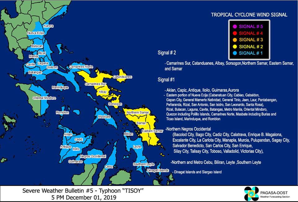
Tropical Cyclone Wind Signal (TCWS ) Number 2, which projected wind of from 61-120 kph in 24 hours, have been hoisted over in the Bicol provinces of Camarines Sur, Catanduanes, Albay, and Sorsogon; and the Eastern Visayas provinces of Northern Samar, Eastern Samar, and Samar.
TCWS Number 1 was hoisted over Aurora, eastern portion of Nueva Ecija (Cabanatuan City, Cabiao, Gabaldon, Gapan City, General Mamerto Natividad, General Tinio, Jaen, Laur, Pantabangan, Peñaranda, Rizal, San Antonio, San Isidro, San Leonardo, Santa Rosa), Rizal, Bulacan, Laguna, Cavite, Batangas, Metro Manila, Oriental Mindoro, Quezon including Polillo Islands, Camarines Norte, Masbate including Burias and Ticao Island, Marinduque, and Romblon Aklan, Capiz, Antique, Iloilo, Guimaras, northern portion of Negros Occidental (Bacolod City, Bago City, Cadiz City, Calatrava, Enrique B. Magalona, Escalante City, La Carlota City, Manapla, Murcia, Pulupandan, Sagay City, Salvador Benedicto, San Carlos City, San Enrique, Silay City, Talisay City, Toboso, Valladolid, Victorias City), Northern and Metro Cebu, Biliran, Leyte, and Southern Leyte Dinagat Islands and Siargao Island. /elb
Disclaimer: The comments uploaded on this site do not necessarily represent or reflect the views of management and owner of Cebudailynews. We reserve the right to exclude comments that we deem to be inconsistent with our editorial standards.
