Pagasa lifts all wind signals as Tropical Depression Dodong crosses West PH Sea
MANILA, Philippines — All Tropical Cyclone Wind Signals (TCWS) have been lifted as Tropical Depression Dodong cut across the West Philippine Sea, the state weather bureau said Saturday.
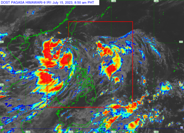
In its 5 a.m. bulletin, the Philippine Atmospheric, Geophysical and Astronomical Services Administration (Pagasa) said Dodong was last seen 270 kilometers west of Sinait, Ilocos Sur, packing maximum sustained winds of 55 kilometers per hour (kph) near the center and gustiness of up to 70 kph.
Dodong was moving westward at 20 kph, it added.
READ: LIVE UPDATES: Tropical Depression Dodong
But even if all TCWS were lifted, Pagasa weather specialist Benison Estareja said gusty wind conditions and moderate to heavy rain may still be experienced in parts of Luzon because of the cyclone-enhanced southwest monsoon, locally termed habagat.

The state weather bureau says on Saturday, July 15, 2023, that the center of Tropical Depression Dodong was last located 260 kilometers West of Sinait, Ilocos Sur. The southwest monsoon, on the other hand, is affecting Central and Southern Luzon, Visayas, and Mindanao. Weather satellite image from Pagasa
“’Yung southwest monsoon o habagat pa rin ang siyang umiiral sa malaking bahagi ng bansa at magpapaulan pa rin ito ngayong araw. Ineenhance pa rin nitong si Dodong [ang habagat]. Ngayong araw po ay pinaka apektado ng pag-ulan ang Zambales, Bataan, and Occidental Mindoro. Hindi ito direktang epekto ni Dodong but ng habagat na siyang pinalalakas ng bagyo,” Estareja warned in a public weather forecast.
(The southwest monsoon or habagat still prevails in large parts of the country and it will still rain today. It’s still being enhanced by Dodong [the southwest monsoon]. Today, Zambales, Bataan, and Occidental Mindoro are most affected by the rain. This is not a direct effect of Dodong but the southwesterly force that the typhoon is strengthening.)
Pagasa likewise cautioned that the same weather conditions may prevail over Metro Manila, Ilocos Region, Cordillera Administrative Region, Batanes, the eastern portion of Isabela, Quirino, Nueva Vizcaya, Zambales, Bataan, Bulacan, Pampanga, Aurora, Calabarzon, Mimaropa, Bicol Region, and Western Visayas due to the southwest monsoon.
Dodong is anticipated to leave the Philippine area of responsibility (PAR) between Saturday afternoon and early morning on Sunday, July 16.
“Bago lumabas ng PAR, mataas ang tiyansa na lumakas pa ito bilang isang tropical storm,” Estareja added.
(Before it exits PAR, there is a high chance that it will strengthen into a tropical storm.)
RELATED STORY
Pagasa: Signal No. 1 up in 12 areas in Luzon as Tropical Depression Dodong keeps strength
kga
Disclaimer: The comments uploaded on this site do not necessarily represent or reflect the views of management and owner of Cebudailynews. We reserve the right to exclude comments that we deem to be inconsistent with our editorial standards.

