Pagasa: Tropical Storm Enteng moves over Kalinga as it slows down
MANILA, Philippines — The Philippine Atmospheric, Geophysical, and Astronomical Services Administration (Pagasa) said that Tropical Storm Enteng had decreased its strength and was moving over Kalinga on Monday evening.
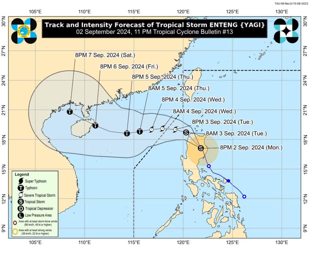
The center of Enteng was located at Rizal, Kalinga with its speed decreasing to 15 kilometers per hour (km/h), moving north northwestward. It was packing maximum sustained winds of 85 km/h near the center, and gustiness of up to 140 km/h.
This was according to Pagasa in its 11 p.m.weather bulletin on Monday, September 2.
READ MORE:
LIVE UPDATES: Tropical Storm Enteng
Tropical Storm Enteng maintains strength, moves over Isabela province
EXPLAINER: What do color-coded rainfall warnings mean?
Enteng would continue to move northwestward over northern Cordillera on Monday night, September 2, said the state weather bureau.
“Enteng is forecast to continue moving northwestward over northern Cordillera Administrative Region tonight and is expected to emerge over the northwestern portion of Ilocos Region by tomorrow morning (3 September),” it said.
READ MORE: Palace suspends classes, gov’t work in Metro Manila, Calabarzon on Sept. 3
“From tomorrow afternoon (September 3) to Thursday, Enteng will move generally westward over the West Philippine Sea. On the track forecast, this tropical cyclone may exit the Philippine Area of Responsibility on Wednesday (4 September) morning,” it added.
A gale warning has been issued by Pagasa over the seaboards of Northern Luzon and eastern seaboards of Central and Southern Luzon as “sea travel is risky for small seacrafts, including all types of motorbancas.”
Meanwhile, the enhanced southwest monsoon, or locally called habagat, will bring moderate to intense rains in other areas of Luzon (especially the western portions) over the next three days.
Tropical Cyclone Wind Signals (TCWS) are declared in the following areas:
TCWS No. 2
- Ilocos Norte
- Northern part of Ilocos Sur (Narvacan, Nagbukel, Santa Maria, Burgos, San Esteban, Santiago, Lidlidda, Banayoyo, San Emilio, Galimuyod, City of Candon, Santa Lucia, Gregorio del Pilar, Quirino, Salcedo, Sigay, Cervantes, Suyo, Santa Cruz, Tagudin, Alilem, Sugpon)
- Apayao
- Abra
- Kalinga
- Mountain Province
- Ifugao
- Cagayan including Babuyan Islands
- Isabela
- Northern part of Quirino (Cabarroguis, Maddela, Aglipay, Diffun, Saguday)
- Northern part of Nueva Vizcaya (Diadi, Bagabag)
- Northern part of Aurora (Casiguran, Dilasag, Dinalungan)
TCWS No.1
- Batanes
- The rest of Ilocos Sur
- La Union
- Northeastern part of Pangasinan (Sison, San Manuel, San Quintin, Tayug, Natividad, San Nicolas)
- Benguet
- The rest of Nueva Vizcaya
- The rest of Quirino
- Central portion of Aurora (Maria Aurora, San Luis, Dipaculao, Baler)
- Northeastern portion of Nueva Ecija (Carranglan, Pantabangan, Bongabon)
The Palace earlier announced that classes in all levels and work in government offices are suspended on Tuesday, September 3 due to the inclement weather brought by Tropical Storm Enteng.
Disclaimer: The comments uploaded on this site do not necessarily represent or reflect the views of management and owner of Cebudailynews. We reserve the right to exclude comments that we deem to be inconsistent with our editorial standards.