Signal No. 1 up in 10 areas as TS Ulysses slows down
MANILA, Philippines — As tropical storm Ulysses (international name: Vamco) slowed down while moving northwestward, Tropical Cyclone Wind Signal (TCWS) No. 1 was hoisted over 10 areas in anticipation of the storm’s associated strong breeze.
In its 5 a.m. severe weather bulletin, the Philippine Atmospheric, Geophysical and Astronomical Services Administration (Pagasa) said that TCWS No. 1, where winds of 30 to 60 kilometers per hour (kph) may be expected in at least 36 hours, is raised over:
Catanduanes
Camarines Norte
Camarines Sur
Albay
Sorsogon
the eastern portion of Masbate (Aroroy, Pio V. Corpuz, Cataingan, Palanas, Uson, Dimasalang, Masbate City, Mobo, Baleno) including Ticao and Burias Islands
the southeastern portion of Quezon (Guinayangan, Tagkawayan, Buenavista, San Andres, San Narciso)
Northern Samar
the northern portion of Samar (Santo Nino, Almagro, Tagapul-An, Tarangnan, Calbayog City, Santa Margarita, Gandara, Pagsanghan, San Jorge, San Jose de Buan, Matuguinao)
the northern portion of Eastern Samar (Maslog, Dolores, Oras, San Policarpo, Arteche, Jipapad)
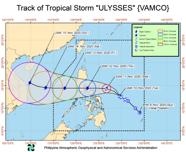
Based on Pagasa’s latest forecast, Ulysses was last spotted at 555 kilometers east of Virac, Catanduanes.
The tropical storm also packed maximum sustained winds of 65 kph near the center, and gustiness of up to 80 kph.
Ulysses was monitored moving northwestward slowly.
State meteorologists said that Ulysses is forecast to intensify to a severe tropical storm on Tuesday night, and may reach typhoon category by Wednesday morning, as well as reaching its peak capacity of 140 to 155 kph by Wednesday afternoon or Wednesday evening.
Pagasa also said that the tropical storm will move generally northwestward on Tuesday, then will turn westward on Wednesday.
Ulysses is also more likely to make landfall over Quezon province on Thursday morning, with a close approach over Catanduanes and Camarines Norte Wednesday afternoon and evening, respectively.
Because of Ulysses, as well as the tail-end of a cold front, light-moderate with at times heavy rains are expected over Cagayan including Babuyan Islands, Isabela, and Apayao. Meanwhile, light to moderate with at times heavy rains due to Ulysses will also be experienced over Aurora, Quezon, Bicol Region, Eastern Visayas, Caraga, and Davao Region.
Meanwhile, Pagasa said that apart from Ulysses, the tail-end of a cold front will bring cloudy skies with scattered rain showers and thunderstorms over Luzon provinces, particularly in Ilocos Norte, Apayao, Batanes, Cagayan, Isabela and Aurora.
As for Metro Manila and the rest of the country, residents may expect partly cloudy to cloudy skies with isolated rain showers in these areas due to localized thunderstorms.
Disclaimer: The comments uploaded on this site do not necessarily represent or reflect the views of management and owner of Cebudailynews. We reserve the right to exclude comments that we deem to be inconsistent with our editorial standards.