Pagasa: Auring slows down but may pass Cebu’s northern tip on Monday morning

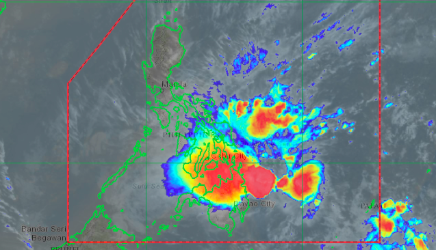
A HIMAWARI satellite image of Tropical Storm Auring (international name: Dujuan) taken on Sunday afternoon, February 21, 2021 | Photo from DOST_Pagasa
CEBU CITY, Philippines – Storm Signal No. 1 that was hoisted in Cebu on Friday evening (February 19) is most likely to continue until Monday (February 22) as threats of Tropical Storm Auring (international name: Dujuan) remain.
The Philippine Atmospheric Geophysical and Astronomical Services Administration in Mactan (Pagasa-Mactan) on Sunday, February 21, forecasted that Auring may hit the northernmost tip of Cebu on Monday morning.
“Our current models show that Auring will make its first landfall between tonight (Sunday) and tomorrow early morning in the regions of Eastern Samar, Leyte, and Dinagat Island… Its eye may also pass the northern tip of Cebu on Monday morning after making its first landfall,” Jomar Eclarino, weather specialist of Pagasa-Mactan, said in Cebuano.
However, Eclarino said the state weather bureau is not ruling out the possibility that Auring would spare Cebu from its wrath.
“Our latest track also showed an increasing likelihood that the storm’s center will not directly pass or hit the northern tip of Cebu. This is because our cone of uncertainty remained wide. We are not ruling out any possibilities as of this moment,” Eclarino explained.
Auring, the first storm to hit the country this 2021, was spotted about 335 kilometers east of Hinatuan town in Surigao del Sur as of 10 a.m. on Sunday.
It maintained a strength of 65 kilometers per hour (kph) with gustiness reaching up to 80 kph, as it approaches, in an almost stationary state, Dinagat Islands in Eastern Mindanao.
Pagasa has already placed the central and southern portions of Eastern Samar (Sulat, Taft, San Julian, Borongan City, Maydolong, Balangkayan, Balangiga, Lawaan, Llorente, Hernani, General Macarthur, Quinapondan, Giporlos, Salcedo, Mercedes, Guiuan), Dinagat Islands and Surigao del Norte including Siargao and Bucas Grande Islands under Storm Signal No. 2.
Localities under Storm Signal No. 1 included Cebu, Sorsogon, Masbate including Ticao and Burias Islands, Albay, Catanduanes, and the eastern portion of Camarines Sur (Caramoan, Presentacion, Sagnay, Buhi, Iriga City, Nabua, Bato, Balatan), Northern Samar, the rest of Eastern Samar, Samar, Biliran, Leyte, Southern Leyte, Bohol, Siquijor, Negros Oriental, the northern and central portions of Negros Occidental (Kabankalan City, Himamaylan City, Binalbagan, Isabela, Moises Padilla, Hinigaran, La Castellana, Pontevedra, San Enrique, La Carlota City, Pulupandan, Valladolid, Bago City, Murcia, Bacolod City, Talisay City, Silay City, Enrique B. Magalona, Victorias City, Manapla, Cadiz City, Sagay City, Escalante City, Toboso, Calatrava, San Carlos City, Salvador Benedicto), the eastern portion of Iloilo (San Rafael, Barotac Viejo, Lemery, Ajuy, Sara, Concepcion, San Dionisio, Batad, Estancia, Balasan, Carles), and the eastern portion of Capiz (Roxas City, Panitan, Ma-Ayon, Cuartero, Dumarao, Panay, Pontevedra, President Roxas, Pilar, Surigao del Sur, Agusan del Norte, Agusan del Sur, Davao Oriental, Davao de Oro, Davao del Norte, Davao City, Camiguin, Misamis Oriental, and Bukidnon.
Weaken
Eclarino said they are forecasting Auring to weaken into a Tropical Depression in the event that it pass northern Cebu.
“This is because of the presence of high-pressure area, and vertical wind shear due to the surge of Amihan (northeast monsoon), all of which not only slows down a storm but can also ruin its circulation,” he said.
In the meantime, Pagasa-Mactan said the entire Cebu will continue to experience light to moderate rains, with occasional heavy ones, until Monday.
“We are urging the public to always be updated and monitor our weather advisories,” he added.
RELATED STORY: 304 passengers stranded after suspension of sea trips in Cebu
/ dcb
Disclaimer: The comments uploaded on this site do not necessarily represent or reflect the views of management and owner of Cebudailynews. We reserve the right to exclude comments that we deem to be inconsistent with our editorial standards.
