Typhoon Egay: Northern portions of Cebu under Signal no. 1
Pagasa image
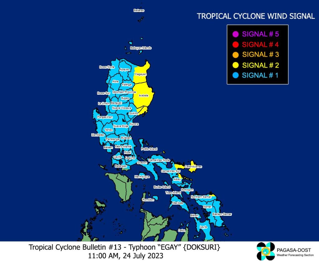
CEBU, Philippines—The northern portion of Cebu was placed under tropical cyclone wind signal no. 1 on Monday noon, July 24, 2023, due to typhoon Egay.
Daanbantayan, Medellin, including Bantayan Islands and Camotes Islands were placed under signal no. 1 as Egay further intensified based on the Pagasa bulletin at 11 a.m.
Egay now has maximum sustained winds of 150 kilometers per hour near the center and gustiness of up to 185 km/h while moving westward.
As of 10 a.m., the center of the eye of the storm is 525 kilometers east of Baler, Aurora.
READ MORE: LIVE UPDATES: Tropical Storm Egay
Signal no. 1
Aside from northern Cebu, signal No. 1 (Range of wind speeds: 39 to 61 km/h) was also raised in the following areas:
Luzon
Sorsogon, the rest of Albay, the rest of Camarines Sur, the rest of Camarines Norte, the rest of Isabela, the rest of Cagayan including Babuyan Islands, Apayao, Abra, Kalinga, Mountain Province, Ifugao, the rest of Quirino, Nueva Vizcaya, Batanes, Masbate including Ticao Island, Burias Island, Quezon including Pollilo Islands, the rest of Aurora, Benguet, Ilocos Sur, Ilocos Norte, La Union, Nueva Ecija, Pangasinan, Tarlac, Zambales, Bulacan, Pampanga, Bataan, Marinduque, Cavite, Metro Manila, Rizal, Laguna, eastern and central portion of Romblon (Banton, Corcuera, Romblon, Magdiwang, Cajidiocan, San Fernando) and the northern and central portion of Batangas (Calaca, Cuenca, Taysan, Lian, Tuy, Balayan, Talisay, Padre Garcia, Agoncillo, Santo Tomas, San Jose, Lemery, Lipa City, Ibaan, City of Tanauan, Mataasnakahoy, Alitagtag, Balete, Nasugbu, San Juan, San Nicolas, Rosario, Laurel, Santa Teresita, Taal, Malvar)
Visayas
Eastern Samar, the rest of Northern Samar, Samar, Biliran, northern and central portion of Leyte (Tunga, Pastrana, San Miguel, Mahaplag, Matag-Ob, Tolosa, Palo, Calubian, Leyte, Mayorga, Julita, Carigara, Babatngon, Dagami, Jaro, Abuyog, San Isidro, Santa Fe, Albuera, Villaba, La Paz, Palompon, Macarthur, Tabontabon, Tanauan, Merida, Ormoc City, Isabel, Javier, Dulag, Capoocan, Alangalang, City of Baybay, Burauen, Tabango, and Tacloban City, Kananga, Barugo).
Signal no. 2
Signal no. 2 (Range of wind speeds: 62 to 88 km/h ) was raised in these areas:
Luzon
Catanduanes, central and eastern portion of Isabela (Palanan, Dinapigue, Santo Tomas, Cabagan, Tumauini, San Pablo, Maconacon, Santa Maria, Quezon, Delfin Albano, Mallig, Quirino, Roxas, Burgos, Ilagan City, Divilacan, San Mariano, Gamu, Naguilian, Benito Soliven, City of Cauayan, Reina Mercedes, Luna, San Manuel, Aurora, Cabatuan, San Guillermo, Echague, Jones, Angadanan, Alicia, San Mateo, San Isidro, San Agustin), eastern portion of Albay (Rapu-Rapu, Bacacay, City of Tabaco, Malilipot, Malinao, Tiwi), eastern portion of Camarines Sur (Caramoan, Presentacion, Garchitorena, Lagonoy, San Jose, Sagñay), northern portion of Aurora (Dilasag, Casiguran, Dinalungan), eastern portion of Quirino (Maddela), eastern and central portion of Cagayan (Santa Ana, Gonzaga, Lal-Lo, Santa Teresita, Buguey, Gattaran, Baggao, Peñablanca, Amulung, Alcala, Iguig, Tuguegarao City, Solana, Enrile), and the northern portion of Camarines Norte (Calaguas and Maculabo Islands)
Visayas
The northeastern portion of Northern Samar (Laoang, Palapag)
Egay forecast
Egay is forecast to track west northwestward in the next 12 hours before turning northwestward and head closer to the landmass of Northern Luzon towards the Luzon Strait. On the track forecast, this typhoon is forecast to cross the Luzon Strait and make landfall or pass very close to the Babuyan Islands-Batanes area between tomorrow late evening and Wednesday afternoon. Typhoon EGAY may exit the Philippine Area of Responsibility (PAR) on Thursday as it moves over the waters southwest of Taiwan.
Egay is forecast to continue intensifying and reach super typhoon category by late tomorrow or on early Wednesday. However, should the track forecast shift closer to the landmass of Luzon, the typhoon may peak at an intensity just below super typhoon threshold. Nevertheless, EGAY is forecast to become a very strong typhoon. A weakening trend may begin by Wednesday afternoon or evening as it enters the cooler waters southwest and west of Taiwan
Disclaimer: The comments uploaded on this site do not necessarily represent or reflect the views of management and owner of Cebudailynews. We reserve the right to exclude comments that we deem to be inconsistent with our editorial standards.