LPA spotted near Mindanao, may enter PAR Wednesday night – Pagasa
If LPA enters PAR, then it will be called "Aghon"
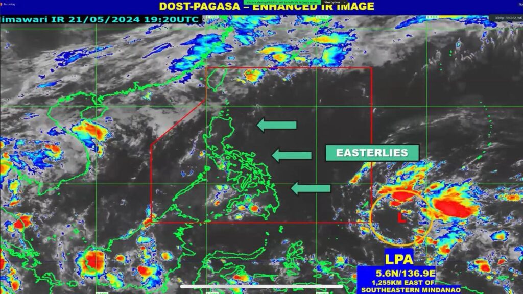
Screengrab from DOST_Pagasa/Facebook live
CEBU CITY, Philippines — The Philippine Atmospheric, Geophysical, and Astronomical Services Administration (Pagasa) is closely monitoring the low-pressure area (LPA) near Mindanao which they had last spotted at 8 a.m. on Wednesday, May 22.
During Pagasa’s climate forum on Wednesday, Loreidin Dela Cruz-Galicia, weather specialist of Pagasa, said the LPA outside the Philippine Area of Responsibility (PAR) was last seen 1,255 kilometers east of southeastern Mindanao.
Should this LPA enter PAR, it will be called “Aghon.”
READ MORE:
Cebu weather: Pagasa forecasts slightly to moderate conditions
Cebu Province declares state of calamity due to El Niño
El Niño damage to PH agri nears P6B
Galicia said that the LPA “may” enter PAR tonight or tomorrow morning, May 23, and may affect or make a landfall over Bicol Region and Eastern Visayas by late Friday or on Saturday.
Moreover, it may also emerge over the waters east of Luzon afterwards and it also has a possibility to develop into a tropical depression around Sunday to Monday.
“Hindi natin niru-rule out ang possibilty na madevelop into a tropical depression after emerging into waters east of Luzon,” Galicia said.
Another scenario that Pagasa observed is if the ridge weakens earlier, the LPA may instead recurve over the Philippine Sea near Bicol Region and Eastern Visayas and develop into a tropical depression by Friday or Saturday.
“Ibig sabihin po nito, likely na ma develop siya into tropical depression kapag nag stay siya off-shore or sa coastal waters po natin,” the weather specialist said.
READ MORE:
Teodoro preps task force amid La Niña watch
Central Luzon braces for La Niña even as dry spell still rages
As of Wednesday, the Easterlies from the Pacific Ocean continues to affect throughout the country which may cause a generally fair weather condition.
Meanwhile, Pagasa said that the entire country can experience a generally fair weather condition with higher chances of thunderstorms in the afternoon and evening from today until tomorrow.
By Friday, the country can also experience generally fair weather with the possibility of the usual isolated rain showers and thunderstorms still in the afternoon and in the evening.
And by Saturday to Sunday, May 25 to 26, the trough of the LPA which may also develop into tropical depression may bring scattered rain showers over the eastern portion of Southern Luzon and Eastern Visayas which may trigger flash floods and landslides.
Pagasa advised the public to keep monitoring the agency’s live updates and weather advisories through their social media platforms.
Disclaimer: The comments uploaded on this site do not necessarily represent or reflect the views of management and owner of Cebudailynews. We reserve the right to exclude comments that we deem to be inconsistent with our editorial standards.