Leon could intensify into super typhoon

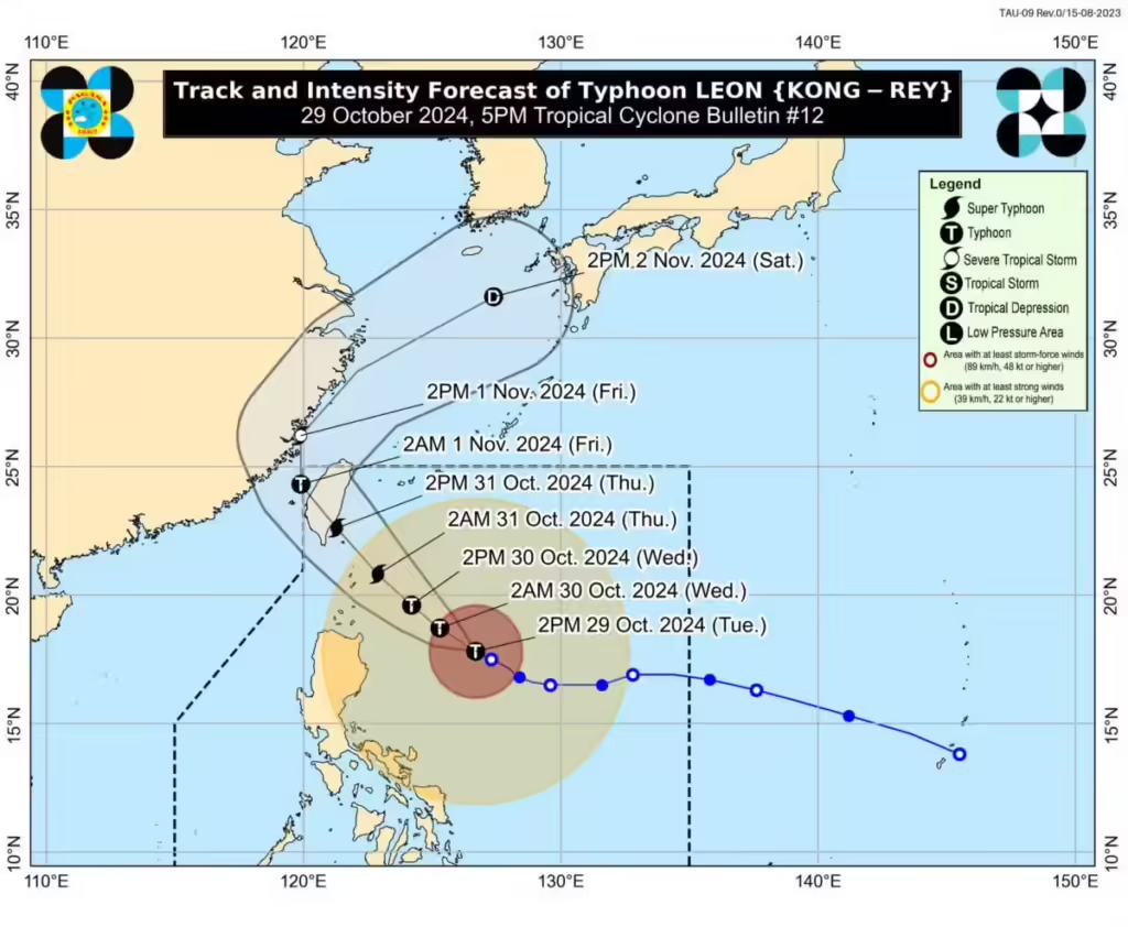
Typhoon Leon. Image from Philippine Atmospheric, Geophysical and Astronomical Services Administration
MANILA, Philippines — Typhoon Leon, known internationally as Kong-rey, intensified rapidly on Tuesday afternoon and may develop into a super typhoon, according to the Philippine Atmospheric, Geophysical and Astronomical Services Administration (Pagasa).
“This tropical cyclone is to continue rapidly intensifying over the Philippine Sea until prior to landfall over Taiwan. Leon will likely be at or near super typhoon intensity during its closest point of approach to Batanes,” Pagasa said in its 5 p.m. cyclone bulletin.
Leon was moving west-northwest at 10 kilometers per hour (kph) and was last monitored 505 kilometers east of Tuguegarao City, Cagayan. It was carrying maximum sustained winds of 150 kph with gusts of up to 185 kph.
Pagasa is not ruling out the possibility that Leon may make landfall in Batanes on Thursday. The typhoon is expected to exit the Philippine Area of Responsibility on Thursday evening (October 31) or Friday early morning (1 November).
Due to Leon’s quick intensification, Pagasa said the following areas remain under wind signals:
Tropical Cyclone Wind Signal (TCWS) No. 2
Batanes
Babuyan Islands
Mainland Cagayan
The northern and eastern portions of Isabela (Santo Tomas, Santa Maria, Quezon, San Mariano, Naguilian, Dinapigue, Delfin Albano, San Pablo, Ilagan City, Benito Soliven, Tumauini, Cabagan, Reina Mercedes, Palanan, Quirino, Divilacan, Gamu, Mallig, Maconacon, Burgos) Apayao
The northern portion of Kalinga (City of Tabuk, Balbalan, Pinukpuk, Rizal), the northern portion of Abra (Tineg, Lacub, Malibcong)
Ilocos Norte
TCWS No. 1
Luzon
The rest of Isabela
Quirino
Nueva Vizcaya
The rest of Kalinga
Mountain Province
Ifugao
Benguet
The rest of Abra
Ilocos Sur
La Union
The eastern portion of Nueva Ecija (General Tinio, Gabaldon, Bongabon, Carranglan, Pantabangan, Laur, Rizal)
Aurora
The northern and eastern portion of Quezon (Infanta, Real, Mauban, Perez, Alabat, Quezon, Calauag, General Nakar, Atimonan, Plaridel, Gumaca, Lopez, Guinayangan, Tagkawayan) including Polillo Islands
Camarines Norte
Camarines Sur
Catanduanes
Albay
The northern portion of Sorsogon (Prieto Diaz, City of Sorsogon, Gubat, Barcelona, Casiguran, Bulusan, Juban, Magallanes, Castilla, Pilar, Donsol)
The weather agency said the wind flow coming towards the circulation of the typhoon will also bring gusty conditions (strong to gale-force winds) over Bataan, Metro Manila, Calabarzon, Mimaropa, Bicol Region, Visayas, Dinagat Islands, Surigao del Norte, and Camiguin.
RELATED STORIES
NDRRMC: 14 of 125 reported deaths due to Kristine validated
Tropical storm Leon won’t impact Cebu, fair weather expected
Disclaimer: The comments uploaded on this site do not necessarily represent or reflect the views of management and owner of Cebudailynews. We reserve the right to exclude comments that we deem to be inconsistent with our editorial standards.
